Vaughn, New Mexico facts for kids
Quick facts for kids
Vaughn, New Mexico
|
|
|---|---|
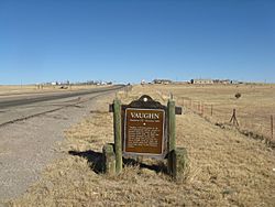
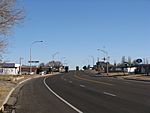
Entering Vaughn from the west
|
|
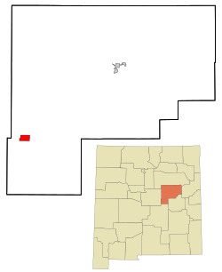
Location of Vaughn, New Mexico
|
|
| Country | United States |
| State | New Mexico |
| County | Guadalupe |
| Area | |
| • Total | 5.60 sq mi (14.50 km2) |
| • Land | 5.60 sq mi (14.50 km2) |
| • Water | 0.00 sq mi (0.00 km2) |
| Elevation | 5,968 ft (1,819 m) |
| Population
(2020)
|
|
| • Total | 286 |
| • Density | 51.08/sq mi (19.72/km2) |
| Time zone | UTC-7 (Mountain (MST)) |
| • Summer (DST) | UTC-6 (MDT) |
| ZIP code |
88353
|
| Area code(s) | 575 |
| FIPS code | 35-82570 |
| GNIS feature ID | 2413424 |
Vaughn is a small town in Guadalupe County, New Mexico, United States. In 2020, about 286 people lived there. This was fewer than the 446 people who lived there in 2010. Vaughn is special because it sits where two big railroad lines meet: the Burlington Northern Santa Fe and Union Pacific lines.
History of Vaughn
Vaughn started in the early 1900s. It was first built as a town for the Southern Pacific Railroad. The town became more important when another railroad line was finished in 1907. This was the Eastern Railway of New Mexico, part of the Atchison, Topeka and Santa Fe system. This new line connected Belen to Clovis, and Vaughn became a key stop, called a "division point."
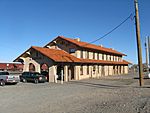
Soon after, a large two-story depot, a place to repair trains called a roundhouse, and a hotel called a Harvey House were built. Vaughn officially became a town in 1919. By 1920, its population had grown to 888 people.
Vaughn was also a filming location for the movie Bobbie Jo and the Outlaw. This movie starred Lynda Carter, who is famous for playing Wonder Woman on TV.
Several police groups help keep the town safe. These include the Guadalupe County Sheriff's Department, New Mexico Rangers, New Mexico State Police, Motor Transportation Police, and the Vaughn Police Department.
Geography of Vaughn
Vaughn is located in the southwestern part of Guadalupe County. Its exact spot is 34°36′5″N 105°12′23″W / 34.60139°N 105.20639°W. Three major U.S. Routes, 54, 60, and 285, all go through the town as 8th Street.
- US 54 goes northeast about 40 miles (64 km) to Santa Rosa, which is the main town of Guadalupe County. It goes southwest about 138 miles (222 km) to Alamogordo.
- US 60 goes east about 118 miles (190 km) to Clovis. It goes west about 104 miles (167 km) to Interstate 25 in the Rio Grande valley.
- US 285 goes southeast about 96 miles (154 km) to Roswell. To the west, it follows US 60 for 16 miles (26 km) to Encino. Then it turns northwest for another 27 miles (43 km) to Interstate 40 at Clines Corners.
The town of Vaughn covers an area of about 5.6 square miles (14.5 square kilometers). All of this area is land.
Population Changes
| Historical population | |||
|---|---|---|---|
| Census | Pop. | %± | |
| 1920 | 888 | — | |
| 1930 | 968 | 9.0% | |
| 1940 | 1,331 | 37.5% | |
| 1950 | 1,356 | 1.9% | |
| 1960 | 1,170 | −13.7% | |
| 1970 | 867 | −25.9% | |
| 1980 | 737 | −15.0% | |
| 1990 | 633 | −14.1% | |
| 2000 | 539 | −14.8% | |
| 2010 | 446 | −17.3% | |
| 2020 | 286 | −35.9% | |
| U.S. Decennial Census | |||
The population of Vaughn has changed over the years. In 2000, there were 539 people living in the town. These people lived in 232 households, and 154 of these were families.
About 25.4% of the people in Vaughn were under 18 years old in 2000. About 16.7% were 65 years old or older. The average age of people in Vaughn was 39 years.
Education
Students in Vaughn attend schools that are part of the Vaughn Municipal Schools district.
Gallery
See also
 In Spanish: Vaughn (Nuevo México) para niños
 | Madam C. J. Walker |
 | Janet Emerson Bashen |
 | Annie Turnbo Malone |
 | Maggie L. Walker |


