
Cochiti, New Mexico facts for kids
Quick facts for kids
Cochiti, New Mexico
|
||
|---|---|---|

Cochiti Pueblo between c. 1871-c. 1907
|
||
|
||

Location of Cochiti
|
||
| Country | United States | |
| State | New Mexico | |
| County | Sandoval | |
| Area | ||
| • Total | 0.78 sq mi (2.02 km2) | |
| • Land | 0.78 sq mi (2.02 km2) | |
| • Water | 0.00 sq mi (0.00 km2) | |
| Elevation | 5,276 ft (1,608 m) | |
| Population
(2020)
|
||
| • Total | 479 | |
| • Density | 614.89/sq mi (237.41/km2) | |
| Time zone | UTC-7 (Mountain (MST)) | |
| • Summer (DST) | UTC-6 (MDT) | |
| ZIP code |
87072
|
|
| Area code(s) | 505 | |
| FIPS code | 35-16560 | |
| GNIS feature ID | 1867383 | |
|
Cochiti Pueblo
|
||

Location in New Mexico

Location in the United States
|
||
| Nearest city | Cochiti, New Mexico | |
| Area | 61 acres (25 ha) | |
| Built | 1250 | |
| Architect | Fr. Juan de Rozas | |
| Architectural style | Pueblo | |
| NRHP reference No. | 74001205 | |
| Significant dates | ||
| Added to NRHP | November 20, 1974 | |

Cochiti (pronounced ko-CHUH-tee) is a special place in Sandoval County, New Mexico, United States. It is a historic pueblo where the Cochiti people, part of the Keresan Nations, have lived for a very long time. Cochiti is also part of the larger Albuquerque area. In 2020, about 479 people lived there. This community is considered a historic district and is listed on the National Register of Historic Places. It is located about 22 miles (35 km) southwest of Santa Fe.
Contents
Cochiti Pueblo: A Historic Community
Where is Cochiti?
Cochiti is located in New Mexico. It covers an area of about 0.78 square miles (2.02 square kilometers), and all of it is land.
Weather in Cochiti
Cochiti has a cold semi-arid climate. This means it gets hot and dry, but also has cold winters. The hottest temperature ever recorded in Cochiti was 108°F (42°C) on July 12, 2020. The coldest temperature recorded was -14°F (-26°C), which happened on December 10, 1978, and February 3, 2011.
Who Lives in Cochiti?
In 2010, there were 528 people living in Cochiti. Most of the people living here, about 95%, are Native American. A small number of residents are White or from other backgrounds. About 7% of the population identifies as Hispanic or Latino.
Many households in Cochiti have children under 18. The average household has about 3 to 4 people. The median age of people in Cochiti is around 34.5 years old. This means half the people are younger than 34.5, and half are older.
The Cochiti People and Their Culture
The Cochiti people are a recognized Native American tribe. Their name for themselves in the Keresan language is K’úutìim’é, which means "People from the Mountains."
The Cochiti people speak Eastern Keres. This is a unique language that is not related to other languages. To help keep their language and culture alive, the Keres Children's Learning Center was started. It is a school where children learn in the Keres language.
The Cochiti Pueblo manages a large area of land, about 53,779 acres (217.63 km2). They also work with the government to protect nearby natural areas like Kasha-Katuwe Tent Rocks National Monument.
Every year on July 14, the Cochiti Pueblo celebrates its annual feast day. This day honors their patron saint, San Buenaventura.
History
The Cochiti people are believed to be descendants of the Ancestral Puebloans. These ancient people lived in cliff dwellings, like those found at Rito de los Frijoles in Bandelier National Monument. Over time, their ancestors moved and settled in different areas.
In 1598, a Spanish explorer named Juan de Oñate arrived at Cochiti Pueblo. At first, the Spanish were impressed by the Pueblo people's farming skills. They traded with each other. However, as time went on, the Spanish tried to make the Cochiti people (and other tribes) live like them. They were forced to pay taxes with crops and cotton.
Spanish missionaries also tried to change the Cochiti people's religion. They gave the pueblos new names, often after Catholic saints. They also built churches, like the San Buenaventura Mission at Cochiti. The Cochiti people were sometimes forced to work and were not allowed to practice their traditional religion.
The Cochiti pueblo people were part of the Pueblo Revolt of 1680. This was a big uprising where Native Americans fought against the Spanish. After the Spanish tried to take back New Mexico, the Cochiti people, along with other tribes, moved to a place called Potrero Viejo. They stayed there until 1693, when they had to leave because of Spanish troops.
Art

Potters from Cochiti and Kewa Pueblo have been making traditional pottery for hundreds of years. They create unique styles for different uses and express their beliefs through their designs. In recent times, their beautiful pots have become popular with people all over the world. Even today, potters use old techniques, but they also create new designs.
Education
Children in Cochiti attend schools in the Bernalillo Public Schools district. This includes Cochiti Elementary & Middle Schools, which are located in nearby Peña Blanca. Older students go to Bernalillo High School.
Notable people from Cochiti Pueblo
Many talented artists come from Cochiti Pueblo:
- Helen Cordero was famous for her "storyteller" pottery figures.
- The Herrera-Ortiz family is known for their traditional pottery and other art forms.
- Laurencita Herrera (1912–1984) made storyteller pottery and vessels.
- Virgil Ortiz (born 1969) is a potter and designer.
- Inez Ortiz (1960–2008) was a traditional Cochiti potter.
- Lisa Holt (born 1980) creates Cochiti pottery with a modern touch.
- The Montoya-Peña family, from both Cochiti and San Ildefonso Pueblo, are known for their paintings.
- Martina Vigil Montoya (1856–1916)
- Tonita Peña (1893–1949) was a painter.
- Joe Herrera (1923–2001) was also a painter.
- Diego Romero (born 1964) creates pottery and prints.
- Mateo Romero (born 1966) is a painter.
In popular culture
In 1969, a documentary film was made for Sesame Street about a Native American boy's life on the Cochiti pueblo. It aired in 1970. The film showed him playing shinny, making tortillas, and creating corn necklaces to sell to tourists.
Gallery
-
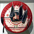
Cochiti Pueblo Ceremonial shield, made before 1883
-
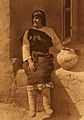
Carolina Quintana (Aiyowitsa) of Cochiti Pueblo, photographed by Edward Curtis


See also
 In Spanish: Cochití (Nuevo México) para niños
