
Kasha-Katuwe Tent Rocks National Monument facts for kids
Quick facts for kids Kasha-Katuwe Tent Rocks National Monument |
|
|---|---|
 |
|

Kasha-Katuwe Tent Rocks National Monument
Location in New Mexico

Kasha-Katuwe Tent Rocks National Monument
Location in the United States
|
|
| Location | Sandoval County, New Mexico, United States |
| Nearest city | Cochiti Pueblo, NM |
| Area | 5,402 acres (21.86 km2) |
| Established | January 17, 2001 |
| Governing body | U.S. Bureau of Land Management |
| Website | Kasha-Katuwe Tent Rocks National Monument |

The Kasha-Katuwe Tent Rocks National Monument is a special place in New Mexico, United States. It is about 40 miles (64 km) southwest of Santa Fe, New Mexico. You can find it close to Cochiti Pueblo. The Bureau of Land Management (BLM) takes care of this monument.
President Bill Clinton made it a U.S. National Monument in January 2001. The name "Kasha-Katuwe" comes from the Keresan language. It means "white cliffs." This monument is part of the BLM's National Conservation Lands.
How These Amazing Rocks Formed
Kasha-Katuwe is located on the Pajarito Plateau. It sits between 5,700 and 6,400 feet (1,737–1,951 meters) above sea level. The unique look of this area comes from ancient volcanoes. About 6 to 7 million years ago, the Jemez Mountains had huge eruptions. These eruptions sent out layers of volcanic rock and ash. This material is called pyroclastic flow.
Over a very long time, wind and water slowly wore away these layers. This process is called weathering and erosion. It created the amazing slot canyons and tent rocks you see today. The tent rocks are made of soft materials like pumice and tuff. Many of them look like cones. Some even have a harder stone "cap" on top. These tent rocks can be from just a few feet tall to as high as 90 feet (27 meters).
Fun Things to Do and See
The BLM has made hiking trails for visitors. There are also places to park and restrooms.
- Slot Canyon Trail: This trail is about 1.5 miles (2.4 km) long. You walk through a narrow slot canyon. Then you climb up about 630 feet (192 meters) to a lookout point. From there, you can see the tent rocks from above.
- Cave Loop Trail: This trail is about 1.2 miles (1.9 km) long. It takes you past the bottom of the cliffs. You will see some of the tent rocks up close. You might also see a small cavate, which is like a cave dwelling.
- Veterans' Memorial Scenic Overlook: This spot was opened in 2004. It has a 1-mile (1.6 km) loop trail. You can see great views of Peralta Canyon and the Jemez Mountains. This overlook is about 3.5 miles (5.6 km) west of the main tent rocks area. The road to it is gravel, so it might not always be open.
The monument is open only during the day. Sometimes, the Cochiti Pueblo Tribal Governor might close it. This can happen for safety reasons. When you hike, be aware of flash floods in the slot canyons. Also, remember the monument is at a high altitude. This means the air is thinner. Dogs are not allowed at the monument.
Pictures of Tent Rocks
-
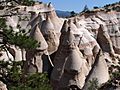
Closeup of several of the largest hoodoos in the formation.
-
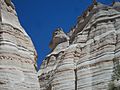
Evidence of erosion in the slot canyon
-
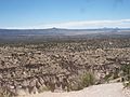
Tent rocks, with Cochiti Pueblo lands and the Rio Grande in the distance
-

Ruins of a Native American cliff dwelling


