
National Register of Historic Places listings in Sandoval County, New Mexico facts for kids

Sandoval County in New Mexico is home to many amazing places that are important to history. These special spots are listed on the National Register of Historic Places. This list helps protect buildings, archaeological sites, and natural areas that tell us about the past.
There are 63 places in Sandoval County on this list. Five of them are even more special and are called National Historic Landmarks. These places are also usually on New Mexico's own list of cultural properties. Some famous ones include Jemez State Monument and Kuaua Ruin, which are also New Mexico Historic Sites.
Contents
Discovering Sandoval County's Historic Treasures
Sandoval County is full of fascinating places that have been recognized for their historical importance. From ancient pueblos where people lived long ago to old churches and natural caves, each site has a story to tell.
Ancient Pueblo Sites
Many of the historic places in Sandoval County are ancient sites where Native American communities once thrived. These sites give us clues about how people lived, what they ate, and their traditions.
Jemez Springs Area Sites
- Amoxiumqua Site (FS-530, LA481): This is one of many archaeological sites near Jemez Springs. These sites are often kept secret to protect them from damage.
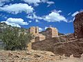
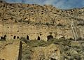
- Astialakwa Archeological District (FS-360, LA-1825): This district includes the ancient Astialakwa site. It's a significant area for understanding early communities.
- Boletsakwa Site (FS-2, LA-136): Another important archaeological site that helps experts learn about the past.
- Hot Springs Pueblo (FS-505, Bj-73): Located northeast of Jemez Springs, this pueblo site is near natural hot springs.
- Jemez Cave: This cave is an archaeological site that holds secrets about ancient people who used it.
- Kiashita Site: Found northwest of Jemez Springs, this site is another key piece of the puzzle of ancient life.
- Kiatsukwa Site (FS-31 and 504, LA-132 and 133): This site provides more information about the early inhabitants of the area.
- Kwastiyukwa Site (FS-11, LA-482): One of many "address restricted" sites, meaning its exact location is kept private to protect it.
- Nanishagi Site (FS-320, LA-541): This site is also protected and helps researchers understand ancient cultures.
- Patokwa Site (FS-5, LA-96): Another archaeological site near Jemez Springs.
- Pejunkwa Site (FS-571, LA-130): This site is part of the rich history found in the Jemez Springs area.
- San Juan Mesa Ruin: An important ruin that gives us insights into past civilizations.
- Tostaskwinu Site (FS-579, LA-479): This site is one of many that contribute to our knowledge of ancient peoples.
- Tovakwa Site: Another archaeological site in the Jemez Springs area.
- Unshagi Site (FS-337, LA-123): This site is also kept private to protect its historical value.
- Wabakwa Site (FS-400, LA-478): This site is important for understanding the history of the region.
- Wahajhamka (FS-573): Another protected archaeological site near Jemez Springs.
Other Pueblo and Ruin Sites
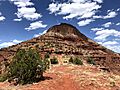
- Big Bead Mesa: This is a National Historic Landmark near Casa Salazar. It's a very important site for understanding ancient history.
- Cochiti Pueblo: Located southwest of Santa Fe, this is a living pueblo with a rich history.
- Espinaso Ridge Pueblo: An archaeological site near Budaghers.
- Guadalupe Ruin: A ruin near Guadalupe that is part of the National Register.
- Jemez Pueblo: North of Bernalillo, this is another active pueblo with deep historical roots.
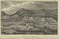
- Jemez State Monument: This site in Jemez Springs includes the ruins of a 17th-century mission and a pueblo. It's a New Mexico State Historic Site.
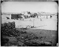
- Kuaua Ruin: Also known as Coronado State Monument, this ruin near Bernalillo is a significant historical site.
- Pueblo of Santo Domingo (Kiua): Northeast of Albuquerque, this is a historic pueblo.
- Pueblo Tuerto: An archaeological site near Budaghers.
- Puye Ruins: A National Historic Landmark near Espanola, known for its cliff dwellings.
- San Jose de las Huertas: A historic site near Placitas.
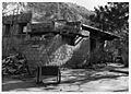
- San Jose de los Jemez Mission and Giusewa Pueblo Site: This is a National Historic Landmark in Jemez Springs, combining a mission and a pueblo site.
- Tamaya: This refers to the Santa Ana Pueblo, north of Bernalillo, a place of great cultural importance.
- Tonque Pueblo: Located southeast of San Felipe Pueblo, this site is also on the National Register.
- Zia Pueblo: West of Bernalillo, this is another active pueblo with a long history.
Historic Buildings and Districts
Beyond ancient sites, Sandoval County also has historic buildings and areas that show us how people lived more recently.
- Abenicio Salazar Historic District: This district in Bernalillo is recognized for its historic buildings along U.S. Route 85.
- Bandelier CCC Historic District: Located off State Road 4 in Bandelier National Monument, this district includes buildings built by the Civilian Conservation Corps (CCC) during the Great Depression.
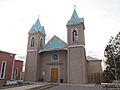
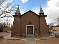
- Our Lady of Sorrows Church: This historic church in Bernalillo, on U.S. Route 85, is an important religious and architectural landmark.
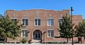
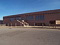
- Roosevelt School: Located on Calle Malinche in Bernalillo, this old school building is a historic landmark.
- San Ysidro Church: This church on Church Road in Corrales is another beautiful and historic religious building.
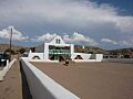
- Santo Domingo Indian Trading Post: This trading post near Domingo, on the former U.S. Route 66, operated for many years and is a piece of local history.
Natural Wonders and Other Sites
Some places on the National Register are natural features or unique sites that hold historical or scientific importance.
- Bandelier National Monument: South of Los Alamos, this large monument includes ancient cliff dwellings and beautiful natural landscapes. It's a National Monument.
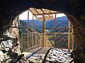
- Sandia Cave: This National Historic Landmark is located along State Road 156 south of Placitas. It's famous for archaeological finds that tell us about very early human presence in the Americas.
- Virgin Mesa Rock Art Site: Near Jemez Springs, this site features ancient rock art, which are drawings or carvings on rocks made by early people.
- Holiday Mesa Logging Camp, Virgin Canyon Logging Camp No. 1, Virgin Mesa Logging Camp No. 1, Virgin Mesa Logging Camp No. 2, Virgin Mesa Logging Camp No. 3: These sites near Jemez Springs are old logging camps. They show us how people worked in the timber industry in the past.
Images for kids
-
The Salazar Building in the Abenicio Salazar Historic District.
-
The Fortress of Astialakwa.
-
The Superintendent's Residence in the Bandelier CCC Historic District.
-
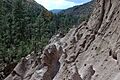
Tent rocks at Bandelier National Monument.
-
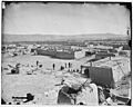
A historic view of Cochiti Pueblo.
-
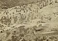
Jemez Pueblo in 1850.
-
Jemez State Monument.
-
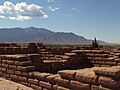
Kuaua Ruin, part of Coronado Historic Site.
-
Our Lady of Sorrows Church in Bernalillo.
-
The Mission Church at Santo Domingo Pueblo.
-
Puye Cliff Dwellings.
-
Roosevelt School in Bernalillo.
-
Jemez State Monument in 1877.
-
San Ysidro Church in Corrales.
-
Sandia Cave.
-
A historic image of Zia Pueblo.

_03.jpg)
.jpg)


