
Embudo, New Mexico facts for kids
Quick facts for kids
Embudo, New Mexico
|
|||||||||||||||||||||||||||
|---|---|---|---|---|---|---|---|---|---|---|---|---|---|---|---|---|---|---|---|---|---|---|---|---|---|---|---|

Embudo, New Mexico
Location in New Mexico

Embudo, New Mexico
Location in the United States
|
|||||||||||||||||||||||||||
| Country | United States | ||||||||||||||||||||||||||
| State | New Mexico | ||||||||||||||||||||||||||
| County | Rio Arriba | ||||||||||||||||||||||||||
| Elevation | 5,824 ft (1,775 m) | ||||||||||||||||||||||||||
| Time zone | UTC-7 (Mountain (MST)) | ||||||||||||||||||||||||||
| • Summer (DST) | UTC-6 (MDT) | ||||||||||||||||||||||||||
| GNIS feature ID | 915823 | ||||||||||||||||||||||||||
|
|||||||||||||||||||||||||||

Embudo, also known as Embudo Station, is a small community in Rio Arriba County, New Mexico, United States. It's not officially a town or city, but a group of homes and businesses. Embudo stretches along both sides of the famous Rio Grande river. You can find it on New Mexico State Road 68, where the Embudo Creek joins the Rio Grande. This area includes smaller places like La Bolsa and Rinconada, and it goes all the way to the Taos County line.
Contents
What's in a Name? Embudo's Funnel Story
The name "Embudo" means "funnel" in Spanish. Early Spanish settlers gave it this name because the spot where the Embudo Creek flows into the Rio Grande reminded them of a funnel. This was due to two cone-shaped hills in the area.
Embudo was first established in 1881. This happened when the Denver and Rio Grande Western Railroad opened a train station there on its "Chili Line." The station was named after a nearby village called San Antonio de Embudo. Until 1902, these two communities shared a post office and were known together as Embudo.
In 1900, San Antonio de Embudo changed its name to Dixon. This was in honor of a Presbyterian missionary named Dixon, who had started a mission there. When the Dixon post office opened in 1902, Embudo lost its own post office. Embudo got a post office again in 1905, but it closed in 1909. Finally, in 1914, Embudo once again had its own post office with the zip code 87531. However, the building was removed in 2016, and mail services moved to the Dixon post office.
Fun Things to See and Do in Embudo
The beautiful section of New Mexico State Road 68 that runs through Embudo is a popular route for tourists. There are many fun attractions to enjoy along the way!
Wineries and Breweries
You can visit several wineries and even a brewery. One popular spot is the Embudo Valley Vineyards and Winery Tasting Room. It's located in a historic, craftsman-style house in the Rinconada part of Embudo. The winery and vineyard are on a large farm right by the Rio Grande. It's a very scenic place between the cities of Santa Fe and Taos.
Unique Museums and Art
You can also explore art galleries and the interesting outdoor Classical Gas Museum. This museum has many cool old gas station signs and other vintage items.
Getting Around Embudo
Today, a concrete bridge crosses the Rio Grande from the state road. This bridge leads to the "Embudo Historic District." This district includes the old railway station and other buildings from the past.
Measuring the Rio Grande
The United States Geological Survey (USGS) has a special station at Embudo. This station measures how much water flows in the Rio Grande. It was the very first USGS stream measuring station ever built! John Wesley Powell set it up in 1888. Embudo was also the first place where the USGS trained people to measure water flow.
Old Roads and Unique Homes
Embudo was once on U.S. Route 64, a major national highway. This road was the main route between Santa Fe and Taos. However, in 1974, US 64 was changed. It no longer passed through Embudo.
Another interesting sight near the old railroad station are the Casa Piedras, also called the Rock-a-Bye. This was the station master's home, about a mile north of the station. It's said that the station master covered his home and other buildings with river rocks to pass the time!
Famous People from Embudo
- Raul Midón – A talented musician.
- Casimiro Barela – A politician from Colorado.
- Susan K. Herrera – A member of the New Mexico House of Representatives.
- Ra Paulette – A unique cave sculptor.
Images for kids
-
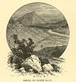
View of the mesa in 1885. The tracks for the Chili Line, now gone, can be seen in the foreground. Note funnel-shaped hill in background.
-
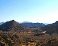
Similar view around 2008. NM Route 68 to Taos is on the right.
-
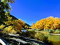
The Rio Grande river just upstream from the Embudo Bridge.
-

One of the cool finds at Johnnie Meier's Classical Gas Museum in Embudo.


