
Logan, New Mexico facts for kids
Quick facts for kids
Logan, New Mexico
|
|
|---|---|
|
Village
|
|

Location within Quay County and New Mexico
|
|
| Country | United States |
| State | New Mexico |
| County | Quay |
| Area | |
| • Total | 11.31 sq mi (29.28 km2) |
| • Land | 10.60 sq mi (27.44 km2) |
| • Water | 0.71 sq mi (1.84 km2) |
| Elevation | 3,806 ft (1,160 m) |
| Population
(2020)
|
|
| • Total | 970 |
| • Density | 91.54/sq mi (35.35/km2) |
| Time zone | UTC-7 (Mountain (MST)) |
| • Summer (DST) | UTC-6 (MDT) |
| ZIP code |
88426
|
| Area code | 575 |
| FIPS code | 35-42040 |
| GNIS ID | 2413566 |
Logan is a small village in Quay County, New Mexico, United States. In 2020, about 970 people lived there. It is known for its connection to the Canadian River and Ute Lake.
Contents
History of Logan
Logan began when the Chicago, Rock Island and Pacific Railroad built a bridge over the Canadian River. A famous Texas Ranger named Eugene Logan came to work on this bridge. The village was named after him.
In the early 1960s, a big project happened near Logan. Ute Dam and its reservoir, which created Ute Lake State Park, were built just west of the village. This brought more people and activities to the area.
In March 2007, strong thunderstorms hit Eastern New Mexico. One of these storms caused a tornado in Logan. The tornado unfortunately damaged many mobile homes.
Geography and Location
Logan is located in eastern New Mexico. The village covers a total area of about 8.4 square miles (21.8 square kilometers). Most of this area is land, with a smaller part being water.
The village sits near the Canadian River. This river is an important natural feature in the region.
Population and People
Logan's population has changed over the years. Here's how many people have lived there during different census counts:
| Historical population | |||
|---|---|---|---|
| Census | Pop. | %± | |
| 1970 | 386 | — | |
| 1980 | 735 | 90.4% | |
| 1990 | 870 | 18.4% | |
| 2000 | 1,094 | 25.7% | |
| 2010 | 1,042 | −4.8% | |
| 2020 | 970 | −6.9% | |
| U.S. Decennial Census | |||
In 2000, there were 1,094 people living in Logan. The village had 485 households. About 23.5% of these households had children under 18. The average age of people in Logan was 48 years old.
Getting Around Logan
Two main roads help people travel to and from Logan. U.S. Route 54 is a major highway that goes through the village. Also, NM 540 ends in Logan.
The Union Pacific Railroad also passes through Logan. This railroad is used for transporting goods.
Images for kids
-
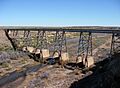
The railroad bridge crossing the Canadian River valley near Logan.

See also
 In Spanish: Logan (Nuevo México) para niños
