Talmage, Kansas facts for kids
Quick facts for kids
Talmage, Kansas
|
|
|---|---|

|
|
| Country | United States |
| State | Kansas |
| County | Dickinson |
| Area | |
| • Total | 0.10 sq mi (0.25 km2) |
| • Land | 0.10 sq mi (0.25 km2) |
| • Water | 0 sq mi (0.0 km2) |
| Elevation | 1,211 ft (369 m) |
| Population
(2020)
|
|
| • Total | 78 |
| • Density | 808/sq mi (312/km2) |
| Time zone | UTC-6 (CST) |
| • Summer (DST) | UTC-5 (CDT) |
| Area code | 785 |
| FIPS code | 20-69925 |
| GNIS ID | 476481 |
Talmage is a small community in Dickinson County, Kansas, United States. It is called a census-designated place (CDP). This means it's a place the government counts for population, but it doesn't have its own local government. In 2020, about 78 people lived there.
Contents
History of Talmage
Early Days and the Railroad
Talmage began in 1887. That year, a railway company called the Atchison, Topeka and Santa Fe Railway (ATSF) built a train line. This line went through Talmage. It connected Neva, Kansas, to Superior, Nebraska.
In 1996, the ATSF railway joined with another company. They formed a new company called BNSF Railway. Even today, many local people still call this train line the "Santa Fe."
First Post Office
The community also got its own post office in 1887. It opened on December 22nd.
Geography of Talmage
Where is Talmage Located?
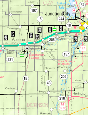
Talmage is in the northwestern part of Dickinson County. It is just south of a main road called K-18. The community is in a valley near Mud Creek.
If you travel on K-18 and then K-15, you can reach Abilene. Abilene is the main city of the county. It is about 11 miles (18 kilometers) southeast of Talmage.
Size of the Area
According to the U.S. Census Bureau, Talmage covers a small area. It is about 0.25 square kilometers (0.10 square miles) in size. All of this area is land.
Population and People
How Many People Live Here?
The number of people living in Talmage changes over time. Here's a quick look at the population counts from the U.S. Decennial Census:
- In 2010, the population was 99 people.
- In 2020, the population was 78 people.
| Historical population | |||
|---|---|---|---|
| Census | Pop. | %± | |
| 2010 | 99 | — | |
| 2020 | 78 | −21.2% | |
| U.S. Decennial Census | |||
Education in Talmage
Local School District
Students in Talmage attend public schools. These schools are part of the Abilene USD 435 school district.
See also
 In Spanish: Talmage (Kansas) para niños
 | Jessica Watkins |
 | Robert Henry Lawrence Jr. |
 | Mae Jemison |
 | Sian Proctor |
 | Guion Bluford |


