
Carlton, Kansas facts for kids
Quick facts for kids
Carlton, Kansas
|
|
|---|---|

Location within Dickinson County and Kansas
|
|

|
|
| Country | United States |
| State | Kansas |
| County | Dickinson |
| Government | |
| • Type | Mayor–Council |
| Area | |
| • Total | 0.17 sq mi (0.44 km2) |
| • Land | 0.17 sq mi (0.44 km2) |
| • Water | 0.00 sq mi (0.00 km2) |
| Elevation | 1,316 ft (401 m) |
| Population
(2020)
|
|
| • Total | 40 |
| • Density | 240/sq mi (91/km2) |
| Time zone | UTC-6 (CST) |
| • Summer (DST) | UTC-5 (CDT) |
| ZIP code |
67448
|
| Area code | 785 |
| FIPS code | 20-10675 |
| GNIS ID | 2393748 |
Carlton is a small city in Dickinson County, Kansas, in the United States. In 2020, about 40 people lived there. It's a quiet place with a rich history.
Contents
History of Carlton
Carlton has an interesting past, especially how it became part of the United States.
Early Days in North America
For thousands of years, the Great Plains of North America were home to nomadic Native American tribes. They moved around, following animals and seasons.
From the 1500s to the 1700s, France claimed a huge part of North America. This area was called New France.
In 1762, after a big war, France secretly gave New France to Spain. This was part of a deal called the Treaty of Fontainebleau.
Becoming Part of the United States
In 1802, Spain gave most of this land back to France. But it didn't stay with France for long!
In 1803, the United States bought a massive amount of land from France. This was called the Louisiana Purchase. It was 828,000 square miles! The land that is now Kansas was part of this huge purchase. It cost only about 2.83 cents per acre.
Kansas and Dickinson County
In 1854, the Kansas Territory was set up. This was a step towards becoming a state. Then, in 1861, Kansas officially became the 34th U.S. state.
Dickinson County was created in 1857. This county included the land where Carlton is today.
Carlton became an important stop for trains. It was a station and a shipping point on the Missouri Pacific Railroad. This meant goods could be sent from here by train.
A post office opened in Carlton in 1872. It helped people send and receive mail for many years. The post office closed in 1995.
Geography of Carlton
Carlton is a very small city. According to the United States Census Bureau, the city covers about 0.17 square miles (0.44 square kilometers). All of this area is land.
Population of Carlton
| Historical population | |||
|---|---|---|---|
| Census | Pop. | %± | |
| 1890 | 121 | — | |
| 1930 | 138 | — | |
| 1940 | 101 | −26.8% | |
| 1950 | 76 | −24.8% | |
| 1960 | 78 | 2.6% | |
| 1970 | 40 | −48.7% | |
| 1980 | 49 | 22.5% | |
| 1990 | 39 | −20.4% | |
| 2000 | 38 | −2.6% | |
| 2010 | 42 | 10.5% | |
| 2020 | 40 | −4.8% | |
| U.S. Decennial Census | |||
The number of people living in Carlton has changed over the years.
2020 Census Information
In 2020, the 2020 United States census counted 40 people living in Carlton. There were 15 households and 11 families. Most people living in Carlton were white.
About 22.5% of the people were under 18 years old. About 25% were 65 years or older. The average age in Carlton was 46 years old.
2010 Census Information
In 2010, there were 42 people living in Carlton. There were 16 households and 14 families. All of the residents were white.
About 37.5% of households had children under 18. Most households (81.3%) were married couples living together. The average age was 46.5 years.
Education
The public schools in Carlton are part of the Chapman USD 473 school district. Students attend schools in Chapman. The mascot for Chapman High School is the Chapman Fighting Irish.
Images for kids
-
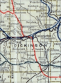
This map from 1915-1918 shows the railroad lines in Dickinson County, Kansas.

See also
 In Spanish: Carlton (Kansas) para niños
