
Conway, Kansas facts for kids
Quick facts for kids
Conway, Kansas
|
|
|---|---|

|
|

Conway, Kansas
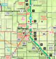
Location in Kansas

Conway, Kansas
Location in the United States
|
|
| Country | United States |
| State | Kansas |
| County | McPherson |
| Elevation | 1,542 ft (470 m) |
| Time zone | UTC-6 (CST) |
| • Summer (DST) | UTC-5 (CDT) |
| Area code | 620 |
| FIPS code | 20-15275 |
| GNIS feature ID | 484354 |
Conway is a small, unincorporated community in McPherson County, Kansas, United States. It is located in the southwestern part of Jackson Township. Conway lies along U.S. Route 56 and a Kansas and Oklahoma Railroad line. It is situated west of the city of McPherson.
Contents
History of Conway

Early Days of Kansas
For thousands of years, the land that is now Kansas was home to Native American tribes. In 1803, the United States gained most of modern Kansas. This happened as part of the Louisiana Purchase.
Later, in 1854, the Kansas Territory was formed. Kansas officially became the 34th U.S. state in 1861. McPherson County, where Conway is located, was established in 1867.
Railroads and the Post Office
In 1878, a railway company called the Marion and McPherson Railway Company was created. This company built a branch line that connected several towns. The line reached McPherson in 1879. It then extended to Lyons in 1880 and Ellinwood in 1881.
This railway line was important for connecting communities. It passed through towns like Florence, Marion, Hillsboro, Canton, Galva, McPherson, Conway, and Lyons.
A post office opened in Conway in 1880. This allowed residents to send and receive mail. The post office served the community for many years. It finally closed in 1983.
Old Trails Road
In the early 20th century, a famous road was established. It was called the National Old Trails Road. This road was also known as the Ocean-to-Ocean Highway. It was created in 1912. This important route passed through Conway, connecting it to other towns like Windom and McPherson.
Conway's Economy
Conway is known for a very large underground storage facility. This facility holds refined petroleum products. It has huge caverns carved deep into the natural salt beds below the ground.
This storage facility can hold over 4 million barrels of propane. It also stores other refined petroleum products. In fact, the Conway storage facility holds about 30% of all the propane stored in the United States! This makes it a very important place for energy supply.
Education in Conway
The local public schools serving the Conway community are part of the McPherson USD 418 school district.
Images for kids
-
KDOT map of McPherson County
