
Aulne, Kansas facts for kids
Quick facts for kids
Aulne, Kansas
|
|
|---|---|

|
|

Aulne, Kansas
Location in Kansas

Aulne, Kansas
Location in the United States
|
|
| Country | United States |
| State | Kansas |
| County | Marion |
| Township | Wilson |
| Founded | 1887 |
| Platted | 1887 |
| Elevation | 1,408 ft (429 m) |
| Time zone | UTC-6 (CST) |
| • Summer (DST) | UTC-5 (CDT) |
| ZIP code |
66861
|
| Area code | 620 |
| FIPS code | 20-03400 |
| GNIS ID | 477370 |
Aulne is a small, unincorporated community in Marion County, Kansas, United States. An unincorporated community means it's a place with a shared identity but no official local government. The name "Aulne" was chosen by railroad officials when the railway was built here in the 1800s.
Aulne is located southwest of Marion. You can find it where Pawnee Road and 140th Street meet. It's right next to the Union Pacific Railroad tracks.
History of Aulne
Early Times in Kansas
For thousands of years, the Great Plains of North America were home to nomadic Native American tribes. These groups moved around, often following animal herds.
In the 16th to 18th centuries, the Kingdom of France claimed a huge area of North America. This included much of what is now Kansas. In 1762, after a war, France secretly gave this land to Spain. This was part of the Treaty of Fontainebleau.
19th Century Changes
In 1802, Spain gave most of this land back to France. Then, in 1803, the United States bought a massive amount of land from France. This was called the Louisiana Purchase. It included most of modern-day Kansas. The U.S. paid about 2.83 cents per acre for this huge area.
In 1854, the Kansas Territory was created. Kansas officially became the 34th U.S. state in 1861. Marion County, where Aulne is located, was set up in 1855.
In 1872, a railroad builder named Col. W. Sherburn thought this spot would be good for a town. He even named it "Sherburn," but the town didn't develop then.
In 1887, the Chicago, Kansas and Nebraska Railway built a train line through Aulne. This line went from Herington south to Caldwell. Over the years, this railroad changed hands many times. Today, it's part of the Union Pacific Railroad. Many local people still call it the "Rock Island" railroad.
A post office served Aulne for many years. It opened on August 19, 1887, and closed on February 28, 1954.
20th Century Events
Aulne was considered as a possible location for Tabor College. However, the college was eventually built in Hillsboro in 1908.
During World War I, there was a rule about telephones in Aulne. The local phone company said that "No German could be spoken over the telephones." This was due to strong feelings against German-Americans at the time.
Geography of Aulne
Aulne is located at coordinates 38.2761266, -97.0766933. It sits in the beautiful Flint Hills and Great Plains regions of Kansas. The community is about halfway between Marion and Peabody. It is right next to the Union Pacific Railroad tracks.
Fun Places to Visit
- Aulne United Methodist Church: This church is located at the north-east corner of 140th Street and Pawnee Road.
- 1890 Marion County Poor Farm: This historic building is about 1 mile west and 2.1 miles north of Aulne. It's a large, three-story limestone house. In the past, it was a place where people who needed help could live and work. They grew their own food and earned their keep. Today, it's a privately owned home, but sometimes tours are available.
- Marion Reservoir: This large lake is about seven miles north of Aulne. It's a great spot for outdoor activities.
Education in Aulne
Students in Aulne attend schools in the Marion–Florence USD 408 public school district. All the schools are located in Marion.
- Marion High School
- Marion Middle School
- Marion Elementary School
The high school is part of T.E.E.N. This is a special network that shares video teaching among five area high schools.
Local Media
Newspapers
- Marion County Record: This newspaper comes from Marion.
- Hillsboro Free Press: This is a free newspaper for the wider Marion County area.
Community Services
Getting Around (Transportation)
Several U.S. Routes are near Aulne. U.S. Route 56 is about 5.75 miles north. U.S. Route 50 is about 7 miles south. U.S. Route 77 is about 4.5 miles east. The Oklahoma Kansas Texas (OKT) line of the Union Pacific Railroad goes through Aulne. However, trains no longer stop there.
Utilities and Services
- Internet: Satellite internet is available from companies like HughesNet, StarBand, and WildBlue.
- TV: You can get satellite TV from DirecTV and Dish Network. Local digital TV stations also provide service.
- Electricity: Electricity for homes and farms is provided by Flint Hills RECA.
- Water: Water for the community and nearby rural areas comes from Marion County RWD #4 (map).
Famous People from Aulne
- Floyd B. Danskin: He was an American politician. He served in the Washington State House of Representatives from 1921 to 1933. He was also the Speaker of the House from 1925 to 1927.
Images for kids
-
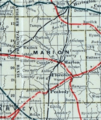
1915 Railroad Map of Marion County

