Waldeck, Kansas facts for kids
Quick facts for kids
Waldeck, Kansas
|
|
|---|---|

|
|
| Country | United States |
| State | Kansas |
| County | Marion |
| Township | Lehigh |
| Founded | 1899 |
| Platted | 1899 |
| Named for | Waldeck |
| Elevation | 1,555 ft (474 m) |
| Population | |
| • Total | 0 |
| Time zone | UTC-6 (CST) |
| • Summer (DST) | UTC-5 (CDT) |
| Area code | 620 |
| FIPS code | 20-74540 |
| GNIS ID | 484810 |
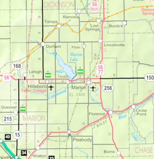
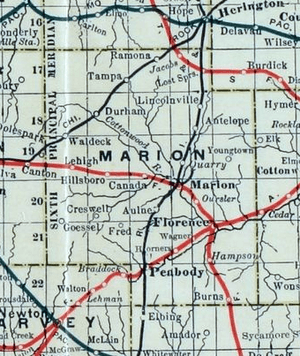
Waldeck is a ghost town in Marion County, Kansas, United States. It's a place where a town used to be, but now no buildings are left. Waldeck was located about 3.5 miles north of Lehigh, right next to a railroad.
History of Waldeck

Early Days in Kansas
For thousands of years, the Great Plains of North America were home to nomadic (traveling) Native American tribes. Later, from the 1500s to the 1700s, the Kingdom of France claimed a large part of North America. In 1762, after a war, France secretly gave this land to Spain.
In 1802, Spain returned most of the land to France. Then, in 1803, the United States bought a huge area, including what is now Kansas, from France. This was part of the Louisiana Purchase, a deal for 828,000 square miles!
In 1854, the Kansas Territory was set up. Kansas officially became the 34th U.S. state in 1861. Marion County, where Waldeck would later be, was created in 1855.
Trails and Railroads
From the 1820s to the 1870s, an important route called the Santa Fe Trail crossed through Marion County. A marker for this historic trail is still located near Waldeck on 245th Street.
Another famous trail, the Chisholm Trail, also went through Marion County from 1867 to 1871. Amazingly, Waldeck was very close to where these two major trails met!
In 1887, the Chicago, Kansas and Nebraska Railway built a main railroad line that went through Waldeck. This line helped connect towns and move goods. Waldeck became a stop where steam trains could get coal and water. A long side track was built there, over a mile long, so trains that didn't need to stop could pass by. This side track is still used today for trains traveling east and west.
The railroad changed things for the Chisholm Trail. Cattle no longer had to travel as far north to Abilene, Kansas. Waldeck even had cattle corrals that were used until the early 1950s, when diesel trains replaced steam engines.
The Town of Waldeck
The town was probably named by Swiss settlers after a place called Waldeck in Germany. The land for Waldeck was sold in 1887, and a railroad depot was built. However, the town didn't grow much.
In 1899, a small town with two blocks was officially planned. Waldeck had a small general store and a school, but it never became a large community.
Waldeck Today
Today, no buildings are left in Waldeck, which is why it's called a ghost town. You can still find a Santa Fe Trail marker nearby on 245th Street.
Geography of Waldeck
Waldeck was located at coordinates 38.4305642, -97.3350299 in the beautiful Flint Hills and Great Plains of Kansas. It was on the north side of 245th Street, between Bison Road and Chisholm Trail Road, in Marion County, Kansas. The railroad tracks ran along its north side, and 245th Street was on its south side. There was also a stockyard (for animals) north of the tracks.
 | Janet Taylor Pickett |
 | Synthia Saint James |
 | Howardena Pindell |
 | Faith Ringgold |


