Lost Springs, Kansas facts for kids
Quick facts for kids
Lost Springs, Kansas
|
|
|---|---|
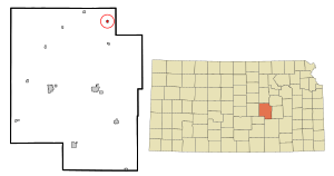
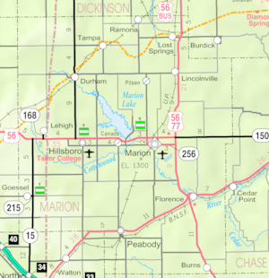
Location within Marion County and Kansas
|
|
|
|
| Country | United States |
| State | Kansas |
| County | Marion |
| Township | Lost Springs |
| Platted | 1887 |
| Incorporated | 1904 |
| Named for | Nearby mineral spring |
| Government | |
| • Type | Mayor–Council |
| Area | |
| • Total | 0.22 sq mi (0.57 km2) |
| • Land | 0.22 sq mi (0.57 km2) |
| • Water | 0.00 sq mi (0.00 km2) |
| Elevation | 1,490 ft (450 m) |
| Population
(2020)
|
|
| • Total | 55 |
| • Density | 250/sq mi (96.5/km2) |
| Time zone | UTC-6 (CST) |
| • Summer (DST) | UTC-5 (CDT) |
| ZIP code |
66859
|
| Area code | 785 |
| FIPS code | 20-42825 |
| GNIS ID | 2395768 |
Lost Springs is a small city in Marion County, Kansas, in the United States. In 2020, 55 people lived there. The city got its name from a nearby spring that would sometimes disappear, making it "lost." This spring was a popular camping spot along the Santa Fe Trail in the 1800s. Lost Springs is located south of Herington, near U.S. Route 77 and the Union Pacific Railroad.
History of Lost Springs
Early Days
For thousands of years, the Great Plains of North America were home to nomadic (traveling) Native American tribes. In the 16th to 18th centuries, France claimed much of North America. In 1762, after a war, France secretly gave this land to Spain.
The 1800s
In 1802, Spain gave most of the land back to France. Then, in 1803, the United States bought a huge amount of land, including what is now Kansas, from France. This was called the Louisiana Purchase. It cost about 2.83 cents per acre!
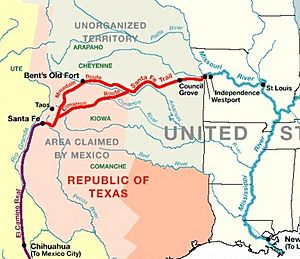
From the 1820s to the 1870s, the Santa Fe Trail was a very important route across the United States. The "Lost Spring" was a favorite camping spot on this trail. It usually had plenty of good water. It was about a day's wagon travel from another spring called Diamond Spring. The spring was called "Lost" because it would sometimes dry up for days, months, or even years. So, travelers returning might not find it. A stagecoach station was built nearby in 1859, called the Lost Springs Station. The Santa Fe Trail was used in Marion County from 1821 to 1866.
In 1854, the Kansas Territory was formed. Then, in 1861, Kansas became the 34th U.S. state. Marion County, where Lost Springs is located, was created in 1855.
A post office named Lost Spring was open from 1861 to 1864. It reopened as Lost Springs in 1879.
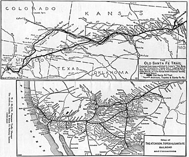
In 1887, the Chicago, Kansas and Nebraska Railway built a train line through Lost Springs. This line later became part of the Union Pacific Railroad. Many local people still call it the "Rock Island" railroad.
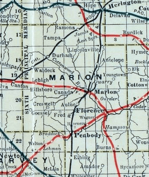
Also in 1887, the Atchison, Topeka and Santa Fe Railway built another line that went through Lost Springs. This line connected many towns, including Strong City and Abilene. In 1996, this railway merged and became the BNSF Railway. Locals often call it the "Santa Fe" line.
Part of the "Santa Fe" line near Lost Springs was removed, but the land for the tracks is still there. The two railways in Lost Springs are connected by a switch. This allows "Rock Island" trains to use the "Santa Fe" tracks to travel northwest.
The 1900s
The National Old Trails Road, also known as the Ocean-to-Ocean Highway, was created in 1912. This important road passed through Lost Springs.
Geography
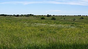
Lost Springs is located in the beautiful Flint Hills and Great Plains areas of Kansas. The Flint Hills are known for their rolling hills and tallgrass prairies. The Great Plains are flat grasslands. The city covers about 0.23 square miles (0.57 square kilometers) of land. The county line is about 1.7 miles east of Lost Springs.
Climate
The weather in Lost Springs has hot, humid summers. Winters are usually mild to cool. This type of weather is called a humid subtropical climate.
Population Information
| Historical population | |||
|---|---|---|---|
| Census | Pop. | %± | |
| 1910 | 276 | — | |
| 1920 | 261 | −5.4% | |
| 1930 | 265 | 1.5% | |
| 1940 | 255 | −3.8% | |
| 1950 | 184 | −27.8% | |
| 1960 | 139 | −24.5% | |
| 1970 | 103 | −25.9% | |
| 1980 | 94 | −8.7% | |
| 1990 | 106 | 12.8% | |
| 2000 | 71 | −33.0% | |
| 2010 | 70 | −1.4% | |
| 2020 | 55 | −21.4% | |
| U.S. Decennial Census | |||
2020 Census Data
In 2020, the 2020 United States census counted 55 people living in Lost Springs. There were 27 households and 19 families. Most people (96.36%) were white. About 7.27% of the population was Hispanic or Latino.
About 23.6% of the people were under 18 years old. The average age in Lost Springs was 40.6 years.
2010 Census Data
In 2010, the census showed that 70 people lived in Lost Springs. There were 26 households. Most residents (82.9%) were White. About 14.3% of the population was Hispanic or Latino.
The average age in the city was 45.5 years. About 18.6% of residents were under 18.
Places to Visit
Lost Springs has one place listed on the National Register of Historic Places (NRHP). This means it's an important historical site.
- The Santa Fe Trail
- Lost Spring (NRHP): This historic spring is about 2.5 miles west of Lost Springs. It was a very important stop on the Santa Fe Trail because it usually had plenty of water for travelers.
- Santa Fe Trail Markers: You can find many markers in the area that show where the old trail ran.
- Santa Fe Trail Self-Guided Auto Tour: You can take a driving tour to see important spots along the trail.
Education
The local public schools are part of the Centre USD 397 school district. The high school is part of T.E.E.N., which is a video teaching network shared by five high schools.
- Centre School: This school is located at 2374 310th St, Lost Springs, KS. It's between Lost Springs and Lincolnville.
- Sports
The mascot for Centre High School is a Cougar. All school sports and activities are managed by the Kansas State High School Activities Association. For the 2010/2011 school year, the football team played in Class 8 Man - Division II.
Media
Lost Springs is served by several local newspapers:
- Marion County Record: This is the main newspaper for Marion County.
- Hillsboro Free Press: A free newspaper for the wider Marion County area.
- The Herington Times: A newspaper from Herington.
Infrastructure
Transportation
U.S. Route 77 is a highway located about 0.8 miles east of Lost Springs. The city is served by the Union Pacific Railroad. This used to be the Chicago, Rock Island and Pacific Railroad. Lost Springs is on the Union Pacific's main line to Fort Worth, Texas. There's a special track called a rail siding where trains can wait for other trains to pass. The Burlington Northern Santa Fe Railway also has a line that connects with the Union Pacific line in Lost Springs.
Utilities
- Internet: Fiber optics internet is provided by TCT. Satellite internet is available from HughesNet, StarBand, and WildBlue.
- TV: Fiber optics TV is provided by TCT. Satellite TV is available from DirecTV and Dish Network. You can also get local digital TV stations.
- Telephone: Fiber optics telephone service is provided by TCT.
- Electricity: Electricity for rural areas is provided by Flint Hills RECA.
Famous People
- Lloyd Metzler: (1913–1980) He was an American economist, a person who studies how money and goods are made and used.
- William R. Novak: (1929–2012) He was a farmer and businessman who served in the Kansas House of Representatives. He was appointed in 1972.
See also
 In Spanish: Lost Springs (Kansas) para niños
 | Toni Morrison |
 | Barack Obama |
 | Martin Luther King Jr. |
 | Ralph Bunche |


