
Hunnewell, Kansas facts for kids
Quick facts for kids
Hunnewell, Kansas
|
|
|---|---|

Location within Sumner County and Kansas
|
|

|
|
| Country | United States |
| State | Kansas |
| County | Sumner |
| Founded | 1880 |
| Incorporated | 1882 |
| Named for | H. H. Hunnewell |
| Area | |
| • Total | 0.55 sq mi (1.43 km2) |
| • Land | 0.55 sq mi (1.43 km2) |
| • Water | 0.00 sq mi (0.00 km2) |
| Elevation | 1,102 ft (336 m) |
| Population
(2020)
|
|
| • Total | 44 |
| • Density | 80.0/sq mi (30.8/km2) |
| Time zone | UTC-6 (CST) |
| • Summer (DST) | UTC-5 (CDT) |
| ZIP code |
67140
|
| Area code | 620 |
| FIPS code | 20-33500 |
| GNIS ID | 2394449 |
Hunnewell is a small city in Sumner County, Kansas, United States. In 2020, about 44 people lived there.
Contents
History of Hunnewell
Hunnewell was started in 1880. It got its name from H. H. Hunnewell, a rich businessman from Boston who owned railroads.
Hunnewell: A Busy Cowtown
In the 1880s, Hunnewell was a very busy place. It was a "cowtown" where Texas ranchers would bring their cattle to be shipped. The Leavenworth, Lawrence and Galveston Railroad helped send cattle quickly to the stockyards in Kansas City, Kansas. Later, the Kansas and Southeastern Railroad was built from Hunnewell south into Oklahoma in 1898.
During its busiest time, Hunnewell had:
- one hotel
- two general stores
- a barber shop
- two dance halls
- eight saloons
Because of all the railroad workers and cowboys, the town was a bit wild. There weren't many police officers around. Ranchers often handled problems like cattle theft themselves. This led to a famous event called the Hunnewell, Kansas Gunfight on October 5, 1884.
Post Office and Railroads Today
A post office opened in Hunnewell in 1880. It stayed open until 1960.
Even today, railroads are important to Hunnewell. The Blackwell Northern Gateway Railroad still runs through the city. It connects to other major railroads like the BNSF at Wellington, Kansas and the Union Pacific.
Geography of Hunnewell
Hunnewell is a small city. According to the United States Census Bureau, it covers about 0.55 square miles (1.43 square kilometers) of land. There is no water within the city limits.
Population Changes Over Time
| Historical population | |||
|---|---|---|---|
| Census | Pop. | %± | |
| 1890 | 168 | — | |
| 1900 | 233 | 38.7% | |
| 1910 | 208 | −10.7% | |
| 1920 | 209 | 0.5% | |
| 1930 | 205 | −1.9% | |
| 1940 | 166 | −19.0% | |
| 1950 | 103 | −38.0% | |
| 1960 | 83 | −19.4% | |
| 1970 | 77 | −7.2% | |
| 1980 | 86 | 11.7% | |
| 1990 | 87 | 1.2% | |
| 2000 | 83 | −4.6% | |
| 2010 | 67 | −19.3% | |
| 2020 | 44 | −34.3% | |
| U.S. Decennial Census | |||
Hunnewell's Population in 2020
In 2020, the 2020 United States census counted 44 people living in Hunnewell. There were 18 households, and 11 of them were families. Most people living in Hunnewell were white.
About 18% of the people were under 18 years old. About 27% were 65 years or older. The average age in the city was 50 years.
Hunnewell's Population in 2010
In 2010, the census showed that 67 people lived in Hunnewell. There were 26 households. Most people were white.
About 28% of the people were under 18 years old. The average age was 42.3 years.
Education
Students in Hunnewell go to public schools in the South Haven USD 509 school district.
Gallery
-
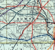
This map from 1915-1918 shows the railroads in Sumner County.
-
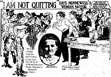
This drawing by reporter Marguerite Martyn shows Mayor Ella Wilson of Hunnewell in 1911. It also includes a photo of her. The all-male city council tried to remove her from office.


See also
 In Spanish: Hunnewell (Kansas) para niños
