Maize, Kansas facts for kids
Quick facts for kids
Maize, Kansas
|
|
|---|---|

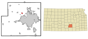
Location within Sedgwick County and Kansas
|
|

|
|
| Country | United States |
| State | Kansas |
| County | Sedgwick |
| Founded | 1886 |
| Incorporated | 1915 |
| Named for | Maize |
| Area | |
| • Total | 9.63 sq mi (24.94 km2) |
| • Land | 9.63 sq mi (24.94 km2) |
| • Water | 0.00 sq mi (0.00 km2) |
| Elevation | 1,348 ft (411 m) |
| Population
(2020)
|
|
| • Total | 5,735 |
| • Density | 595.5/sq mi (229.95/km2) |
| Time zone | UTC-6 (CST) |
| • Summer (DST) | UTC-5 (CDT) |
| ZIP code |
67101
|
| Area code | 316 |
| FIPS code | 20-44200 |
| GNIS ID | 473821 |
Maize is a city located in Sedgwick County, Kansas, United States. It's like a smaller town right next to the bigger city of Wichita. In 2020, about 5,735 people lived there. The city got its name "Maize" from a Native American word for "corn". This makes sense because Maize is in a farming area known as the Corn Belt.
Contents
History of Maize: From Founding to Growth
Maize was started in 1886 by a group called the Maize Town Company. It was the first stop on the Wichita and Colorado Railway after leaving Wichita. The town's post office and first church opened in the same year.
In 1887, Maize got its first school. A newspaper started in 1895, and the first bank, Maize State Bank, opened in 1901. By 1908, the town had a busy business area. In 1915, Maize officially became a city.
Challenges in the 1930s and 1940s
Maize faced some tough times in the 1930s and 1940s. The Dust Bowl hit in 1934–35, causing huge dust storms. In 1936, there was a big problem with grasshoppers. A flood also affected the area in 1944.
Maize's Recent Growth
After 1950, Maize started to grow very quickly. Its population more than doubled by 1956. This growth has continued, especially as Wichita has expanded. Now, Maize is an important suburb of Wichita.
Geography: Where is Maize Located?
Maize is located at 37°46′45″N 97°28′2″W / 37.77917°N 97.46722°W. It sits about 1,348 feet (411 meters) above sea level. The city is on the west side of Big Slough Creek. It's also about 3 miles (4.8 km) southwest of the Arkansas River.
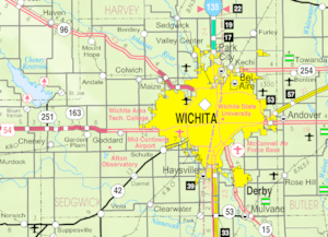
Maize is in the Wellington-McPherson Lowlands region of the Great Plains. You can find it in south-central Kansas, just northwest of Wichita on K-96. The city covers about 8.84 square miles (22.90 square kilometers) of land.
Population and People of Maize
| Historical population | |||
|---|---|---|---|
| Census | Pop. | %± | |
| 1920 | 189 | — | |
| 1930 | 229 | 21.2% | |
| 1940 | 198 | −13.5% | |
| 1950 | 266 | 34.3% | |
| 1960 | 623 | 134.2% | |
| 1970 | 785 | 26.0% | |
| 1980 | 1,294 | 64.8% | |
| 1990 | 1,520 | 17.5% | |
| 2000 | 1,868 | 22.9% | |
| 2010 | 3,420 | 83.1% | |
| 2020 | 5,735 | 67.7% | |
| U.S. Decennial Census 2010-2020 |
|||
Maize is part of the larger Wichita, KS Metropolitan Statistical Area. This means it's connected to the economy and community of Wichita.
Maize Population in 2020
The 2020 United States census showed that 5,735 people lived in Maize. There were 2,111 households, which are groups of people living together. The population density was about 589 people per square mile.
Most residents, about 81.81%, were white. About 2.91% were black, and 1.15% were Native American. About 1.62% were Asian, and 0.07% were Pacific Islander. About 2.58% were from other races, and 9.85% were from two or more races. People of Hispanic or Latino background made up 10.27% of the population.
In Maize, 40.5% of households had children under 18. The average household had 2.5 people. The average family had 3.1 people. About 30.6% of the population was under 18 years old. The median age in the city was 33.3 years.
Maize Population in 2010
In the census of 2010, there were 3,420 people living in Maize. The population density was about 387 people per square mile.
The racial makeup was mostly White (91.3%). There were also African American (1.5%), Native American (1.1%), and Asian (1.1%) residents. About 7.4% of the population was Hispanic or Latino.
About 49.4% of households had children under 18. The average household size was 2.92 people. The average family size was 3.28 people. The median age was 30.7 years. About 34.1% of residents were under 18.
Education in Maize: Schools for All Ages
Maize has a public school district called Maize USD 266. It runs fourteen schools in and around the city.
- Maize High School (grades 9-12)
- Maize South High School (grades 9-12)
- Complete High School Maize (grades 9-12), an alternative school
- Maize Career Academy (grades 9-12)
- Maize South Middle School (grades 7-8)
- Maize Middle School (grades 7-8)
- Maize South Intermediate School (grades 5-6)
- Maize Intermediate School (grades 5-6)
- Pray-Woodman Elementary School (grades 2-5)
- Maize South Elementary School (grades 2-5)
- Maize Central Elementary School (grades K-5)
- Maize Elementary School (grades K-1)
- Vermillion Elementary School
- Early Childhood Center (Pre-Kindergarten)
Infrastructure and Transportation in Maize
Roads and Railways
K-96 is a highway that runs through the middle of the city. It's important to know that city police usually don't have authority on K-96. The Sedgwick County Sheriff's deputies and the Kansas Highway Patrol handle law enforcement there.
The Hutchinson line of the Kansas and Oklahoma Railroad also passes through Maize. This railway helps move goods and materials.
Maize Airport
Maize has its own airport called Maize Airport. It's a privately owned airport that can be used by the public. It is located about 2 nautical miles (3.7 km) southeast of the city center.
Notable People from Maize
Some well-known individuals have lived in or were born in Maize:
- Nancy Kassebaum (born 1932) – She was a U.S. Senator for Kansas.
- Richard Kassebaum (1960-2008) – He was a filmmaker who made documentaries.
- Miles Ukaoma (born 1992) – He is an Olympian, meaning he competed in the Olympic Games.
See also
 In Spanish: Maize para niños
 | Leon Lynch |
 | Milton P. Webster |
 | Ferdinand Smith |

