Wichita, KS Metropolitan Statistical Area facts for kids
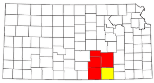
The Wichita, KS Metropolitan Statistical Area is like a big neighborhood made up of five counties in south-central Kansas. Its main city is Wichita. In 2013, about 637,989 people lived here. It is the largest metropolitan area in the whole state of Kansas! Think of it as a busy hub where many people live and work, all connected to the big city of Wichita.
Contents
Counties in the Area
This metropolitan area includes five different counties. These counties work together and are connected by the main city of Wichita.
Cities and Towns
Many cities and towns are part of the Wichita Metropolitan Area. Their populations are based on the 2010 census.
Largest Cities
- Wichita: This is the main and largest city in the area. It had 389,902 people living there.
Mid-sized Towns
These towns have populations between 10,000 and 25,000 people.
- Derby: Pop: 22,158
- Newton: Pop: 19,132
- El Dorado: Pop: 13,021
- Winfield: Pop: 12,204
- Arkansas City: Pop: 12,136
- Andover: Pop: 11,791
- Haysville: Pop: 10,826
Smaller Communities
Many other towns and communities are also part of this metropolitan area. Some have populations between 5,000 and 10,000, while others are even smaller.
- Augusta: Pop: 9,274
- Wellington: Pop: 8,172
- Park City: Pop: 7,297
- Valley Center: Pop: 6,822
- Bel Aire: Pop: 6,769
- Mulvane: Pop: 6,111
- Goddard: Pop: 4,344
- Rose Hill: Pop: 3,931
- Hesston: Pop: 3,709
- Maize: Pop: 3,420
- Clearwater: Pop: 2,481
- Cheney: Pop: 2,094
- Halstead: Pop: 2,085
- Kechi: Pop: 1,909
- North Newton: Pop: 1,759
- Douglass: Pop: 1,700
- Sedgwick: Pop: 1,695
- Belle Plaine: Pop: 1,681
- Towanda: Pop: 1,450
- Colwich: Pop: 1,327
- Conway Springs: Pop: 1,272
- Caldwell: Pop: 1,068
- Oxford: Pop: 1,049
There are also many towns with fewer than 1,000 people, like Andale, Burrton, Benton, and Mount Hope. These smaller communities help make up the diverse population of the Wichita Metropolitan Area.
See also
 In Spanish: Área metropolitana de Wichita para niños
 | Aaron Henry |
 | T. R. M. Howard |
 | Jesse Jackson |


