
Coolidge, Kansas facts for kids
Quick facts for kids
Coolidge, Kansas
|
|
|---|---|

Welcome Sign (2010)
|
|

Location within Hamilton County and Kansas
|
|

|
|
| Country | United States |
| State | Kansas |
| County | Hamilton |
| Founded | 1880 |
| Incorporated | 1886 |
| Named for | Thomas Coolidge |
| Area | |
| • Total | 0.46 sq mi (1.20 km2) |
| • Land | 0.46 sq mi (1.20 km2) |
| • Water | 0.00 sq mi (0.00 km2) |
| Elevation | 3,353 ft (1,022 m) |
| Population
(2020)
|
|
| • Total | 80 |
| • Density | 174/sq mi (67/km2) |
| Time zone | UTC-7 (Mountain (MST)) |
| • Summer (DST) | UTC-6 (MDT) |
| ZIP code |
67836
|
| Area code | 620 |
| FIPS code | 20-15400 |
| GNIS ID | 2393627 |
Coolidge is a small city located in Hamilton County, Kansas, United States. It sits right along Highway 50, about one mile east of the border with Colorado. In 2020, the city had a population of 80 people.
Contents
History of Coolidge
The city of Coolidge got its name from Thomas Jefferson Coolidge. He was once the president of a very important railroad company called the Atchison, Topeka and Santa Fe Railway.
The first post office in Coolidge opened in July 1881. This means people could send and receive mail there a long time ago! The city was officially started in 1886.
Geography and Climate
Coolidge covers a total area of about 0.46 square miles (1.20 square kilometers). All of this area is land, meaning there are no large lakes or rivers within the city limits.
Coolidge's Climate
Coolidge has what is called a semi-arid climate. This means the area usually gets very little rain. It's often dry, but not quite a desert.
Population and People
| Historical population | |||
|---|---|---|---|
| Census | Pop. | %± | |
| 1890 | 472 | — | |
| 1900 | 288 | −39.0% | |
| 1910 | 145 | −49.7% | |
| 1920 | 144 | −0.7% | |
| 1930 | 135 | −6.2% | |
| 1940 | 132 | −2.2% | |
| 1950 | 168 | 27.3% | |
| 1960 | 117 | −30.4% | |
| 1970 | 102 | −12.8% | |
| 1980 | 82 | −19.6% | |
| 1990 | 90 | 9.8% | |
| 2000 | 86 | −4.4% | |
| 2010 | 95 | 10.5% | |
| 2020 | 80 | −15.8% | |
| U.S. Decennial Census | |||
2020 Census Information
In 2020, the 2020 United States census counted 80 people living in Coolidge. There were 28 households, which are like homes where people live, and 16 families. The population density was about 173 people per square mile.
Most of the people, about 65%, were white. About 20% of the people were from other races, and 8.75% were from two or more races. About 27.5% of the population identified as Hispanic or Latino.
About 31% of the people were under 18 years old. The average age in Coolidge was 35 years.
2010 Census Information
The census in 2010 showed that 95 people lived in Coolidge. There were 43 households. About 30% of these households had children under 18 living there.
The average age of people in the city was 42.1 years. About 25% of the residents were under 18 years old.
Education in Coolidge
Students in Coolidge attend public schools run by the Syracuse USD 494 school district. This school district is located in the nearby city of Syracuse.
Gallery
-
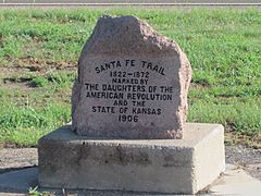
Santa Fe Trail marker in Coolidge.
-
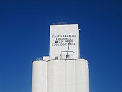
Grain elevator in Coolidge.
-
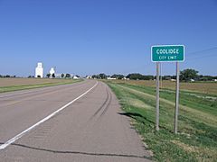
Looking westward on U.S. Highway 50/400.
-
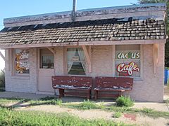
"Cactus Café" in Coolidge. It was reopened as "Western Trail Cafe and then reopened again as Gracie’s Cafe".


See also
 In Spanish: Coolidge (Kansas) para niños
