
Lakin, Kansas facts for kids
Quick facts for kids
Lakin, Kansas
|
|
|---|---|
|
City and County seat
|
|

Downtown Lakin (2010)
|
|

Where Lakin is in Kearny County (left) and Kansas (right)
|
|

A map of Kearny County
|
|
| Country | United States |
| State | Kansas |
| County | Kearny |
| Founded | 1874 |
| Became a city | 1888 |
| Named for | David Lakin |
| Area | |
| • Total | 0.95 sq mi (2.45 km2) |
| • Land | 0.95 sq mi (2.45 km2) |
| • Water | 0.00 sq mi (0.00 km2) |
| Elevation | 3,005 ft (916 m) |
| Population
(2020)
|
|
| • Total | 2,205 |
| • Density | 2,321/sq mi (900.0/km2) |
| Time zone | UTC-6 (CST) |
| • Summer (DST) | UTC-5 (CDT) |
| ZIP code |
67860
|
| Area code | 620 |
| FIPS code | 20-38175 |
| GNIS ID | 2395615 |
Lakin is a city in Kansas, United States. It is the main town, also called the county seat, of Kearny County. In 2020, about 2,205 people lived there. Lakin is located right next to Highway 50.
Contents
History of Lakin
Lakin started in the spring of 1873. A person named John O'Loughlin set up a trading post there. This was right after the Atchison, Topeka and Santa Fe Railway was finished. The railway company named the town Lakin. It was named after David Long Lakin, who used to be their treasurer.
Lakin became the county seat in 1888. This means it became the main town for the county's government. A post office has been open in Lakin since March 1874.
Geography and Climate
Lakin covers a total area of about 0.98 square miles (2.5 square kilometers). All of this area is land.
Lakin's Climate
Lakin has a cold semi-arid climate. This means it is usually dry and can have very hot summers and cold winters.
The hottest temperature ever recorded in Lakin was 115°F (46°C). This happened on August 7 and 9, 1896. The coldest temperature recorded was -23°F (-31°C) on January 12, 1942.
People of Lakin
| Historical population | |||
|---|---|---|---|
| Census | Pop. | %± | |
| 1890 | 258 | — | |
| 1900 | 259 | 0.4% | |
| 1910 | 337 | 30.1% | |
| 1920 | 556 | 65.0% | |
| 1930 | 739 | 32.9% | |
| 1940 | 709 | −4.1% | |
| 1950 | 1,618 | 128.2% | |
| 1960 | 1,432 | −11.5% | |
| 1970 | 1,570 | 9.6% | |
| 1980 | 1,823 | 16.1% | |
| 1990 | 2,060 | 13.0% | |
| 2000 | 2,316 | 12.4% | |
| 2010 | 2,216 | −4.3% | |
| 2020 | 2,205 | −0.5% | |
| U.S. Decennial Census | |||
What the 2020 Census Shows
In 2020, the 2020 United States census counted 2,205 people in Lakin. There were 796 households and 555 families.
Most people in Lakin, about 64%, were white. About 37% of the population was Hispanic or Latino.
- About 39% of households had children under 18 living there.
- More than half, about 54%, were married couples living together.
- About 24% of households were people living alone.
The average age of people in Lakin was 34.8 years. About 28.6% of the people were under 18 years old.
Education in Lakin
The public schools in Lakin are part of the Lakin USD 215 school district.
Famous People from Lakin
- Frank Luther (1899–1980), a country music singer.
- Russ Jennings, who was a member of the Kansas House of Representatives.
Gallery
-
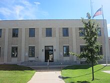
The Kearny County Courthouse (2010)
-
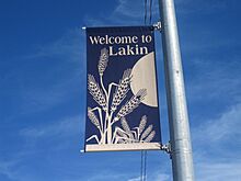
A welcome sign for Lakin
-
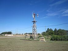
The O'Loughlin Windmill in Lakin
-
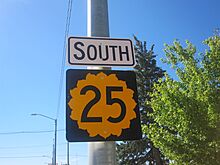
Kansas Highway 25 goes through Lakin


See also
 In Spanish: Lakin para niños
