
Boise City, Oklahoma facts for kids
Quick facts for kids
Boise City, Oklahoma
|
|
|---|---|

Cimarron County Courthouse (2024)
|
|

Location within Cimarron County and Oklahoma
|
|
| Country | United States |
| State | Oklahoma |
| County | Cimarron |
| Founded | 1908 |
| Incorporated | 1925 |
| Area | |
| • Total | 1.48 sq mi (3.82 km2) |
| • Land | 1.48 sq mi (3.82 km2) |
| • Water | 0.00 sq mi (0.00 km2) |
| Elevation | 4,167 ft (1,270 m) |
| Population
(2020)
|
|
| • Total | 1,166 |
| • Density | 789.97/sq mi (305.02/km2) |
| Time zone | UTC-6 (CST) |
| • Summer (DST) | UTC-5 (CDT) |
| ZIP code |
73933
|
| Area code(s) | 580 |
| FIPS code | 40-07300 |
| GNIS ID | 1090365 |
Boise City (pronounced BOYSS) is a city in Oklahoma, United States. It is the main town in Cimarron County, located in the part of Oklahoma known as the Panhandle. In 2020, about 1,166 people lived there.
Contents
History of Boise City
Boise City was started in 1908 by a group of developers. They tried to attract people by saying the town had paved streets, lots of businesses, and even a railroad. However, these promises were not true. The developers also sold land they didn't actually own.
Because of their false advertising, two of the developers were sent to prison. Even with this rocky start, the town grew and officially became a city in 1925.
The name "Boise City" might come from a Civil War hero named Captain Boice, or from Boise, Idaho. Another idea is that it came from the Boise Cattle Company, which used to raise cattle in the area. Some people think the name was chosen to make the town sound like a place with lots of trees, since "boisé" means "wooded" in French. This would have been part of the original false promises.
In the 1930s, Boise City was hit hard by the Dust Bowl. This was a time when severe dust storms damaged farms and made life very difficult.
Accidental Bombing in World War II
During World War II, something very unusual happened in Boise City. On July 5, 1943, a U.S. bomber crew accidentally dropped practice bombs on the town. The pilots were training and got confused, mistaking the town's lights for their target.
Luckily, no one was hurt, and there was only minor damage. The bombs were just practice bombs, filled with sand and a small amount of dynamite. The pilots were very embarrassed about the mistake. Years later, for the 50th anniversary of the event, the bomber crew was invited back, but they chose not to come.
Geography and Climate
Boise City is located at 36°43′48″N 102°30′41″W / 36.73000°N 102.51139°W. The city covers about 1.3 square miles, and it's all land.
Boise City's Weather
| Weather chart for Boise City, Oklahoma | |||||||||||||||||||||||||||||||||||||||||||||||
|---|---|---|---|---|---|---|---|---|---|---|---|---|---|---|---|---|---|---|---|---|---|---|---|---|---|---|---|---|---|---|---|---|---|---|---|---|---|---|---|---|---|---|---|---|---|---|---|
| J | F | M | A | M | J | J | A | S | O | N | D | ||||||||||||||||||||||||||||||||||||
|
0.5
52
20
|
0.4
56
23
|
1.1
64
30
|
1.4
72
38
|
1.8
80
47
|
2.3
90
58
|
3.1
94
63
|
3.2
91
62
|
1.8
85
54
|
1.5
74
40
|
0.6
61
29
|
0.7
51
22
|
||||||||||||||||||||||||||||||||||||
| temperatures in °F precipitation totals in inches |
|||||||||||||||||||||||||||||||||||||||||||||||
|
Metric conversion
|
|||||||||||||||||||||||||||||||||||||||||||||||
Boise City has a semi-arid climate. This means it has mild, dry winters and long, hot summers with more rain. The temperature can change a lot between day and night.
It's also known as the snowiest place in Oklahoma! On average, it gets about 31.8 inches of snow each year.
| Climate data for Boise City, Oklahoma, 1991–2020 normals, extremes 1908–2020 | |||||||||||||
|---|---|---|---|---|---|---|---|---|---|---|---|---|---|
| Month | Jan | Feb | Mar | Apr | May | Jun | Jul | Aug | Sep | Oct | Nov | Dec | Year |
| Record high °F (°C) | 82 (28) |
86 (30) |
91 (33) |
97 (36) |
102 (39) |
109 (43) |
108 (42) |
107 (42) |
105 (41) |
97 (36) |
88 (31) |
84 (29) |
109 (43) |
| Mean maximum °F (°C) | 71.0 (21.7) |
73.3 (22.9) |
80.8 (27.1) |
86.8 (30.4) |
93.6 (34.2) |
100.2 (37.9) |
101.5 (38.6) |
99.1 (37.3) |
95.2 (35.1) |
87.7 (30.9) |
78.5 (25.8) |
71.0 (21.7) |
102.5 (39.2) |
| Mean daily maximum °F (°C) | 51.8 (11.0) |
55.7 (13.2) |
64.2 (17.9) |
71.5 (21.9) |
80.4 (26.9) |
90.1 (32.3) |
93.8 (34.3) |
90.8 (32.7) |
84.6 (29.2) |
73.5 (23.1) |
61.4 (16.3) |
51.3 (10.7) |
72.4 (22.4) |
| Daily mean °F (°C) | 36.1 (2.3) |
39.1 (3.9) |
46.8 (8.2) |
54.5 (12.5) |
63.8 (17.7) |
74.0 (23.3) |
78.3 (25.7) |
76.1 (24.5) |
69.2 (20.7) |
57.0 (13.9) |
45.3 (7.4) |
36.5 (2.5) |
56.4 (13.6) |
| Mean daily minimum °F (°C) | 20.4 (−6.4) |
22.6 (−5.2) |
29.5 (−1.4) |
37.6 (3.1) |
47.3 (8.5) |
57.9 (14.4) |
62.8 (17.1) |
61.5 (16.4) |
53.8 (12.1) |
40.4 (4.7) |
29.3 (−1.5) |
21.7 (−5.7) |
40.4 (4.7) |
| Mean minimum °F (°C) | 2.7 (−16.3) |
4.4 (−15.3) |
12.1 (−11.1) |
22.9 (−5.1) |
33.9 (1.1) |
46.5 (8.1) |
54.8 (12.7) |
53.6 (12.0) |
38.0 (3.3) |
25.0 (−3.9) |
12.5 (−10.8) |
2.1 (−16.6) |
−5.2 (−20.7) |
| Record low °F (°C) | −24 (−31) |
−18 (−28) |
−12 (−24) |
6 (−14) |
19 (−7) |
31 (−1) |
39 (4) |
36 (2) |
25 (−4) |
7 (−14) |
−7 (−22) |
−17 (−27) |
−24 (−31) |
| Average precipitation inches (mm) | 0.50 (13) |
0.36 (9.1) |
1.10 (28) |
1.40 (36) |
1.82 (46) |
2.28 (58) |
3.12 (79) |
3.23 (82) |
1.75 (44) |
1.48 (38) |
0.56 (14) |
0.74 (19) |
18.34 (466) |
| Average snowfall inches (cm) | 7.3 (19) |
2.5 (6.4) |
7.2 (18) |
2.3 (5.8) |
0.2 (0.51) |
0.0 (0.0) |
0.0 (0.0) |
0.0 (0.0) |
0.0 (0.0) |
1.3 (3.3) |
3.1 (7.9) |
7.9 (20) |
31.8 (81) |
| Average precipitation days (≥ 0.01 in) | 2.7 | 2.6 | 3.6 | 4.4 | 5.9 | 5.8 | 7.2 | 6.6 | 4.0 | 3.4 | 2.6 | 3.2 | 52.0 |
| Average snowy days (≥ 0.1 in) | 2.9 | 1.6 | 2.2 | 0.8 | 0.1 | 0.0 | 0.0 | 0.0 | 0.0 | 0.3 | 1.2 | 2.8 | 11.9 |
| Source 1: NOAA | |||||||||||||
| Source 2: XMACIS2 (mean maxima/minima 1981–2010) | |||||||||||||
People of Boise City
| Historical population | |||
|---|---|---|---|
| Census | Pop. | %± | |
| 1930 | 1,256 | — | |
| 1940 | 1,144 | −8.9% | |
| 1950 | 1,902 | 66.3% | |
| 1960 | 1,978 | 4.0% | |
| 1970 | 1,993 | 0.8% | |
| 1980 | 1,761 | −11.6% | |
| 1990 | 1,509 | −14.3% | |
| 2000 | 1,483 | −1.7% | |
| 2010 | 1,266 | −14.6% | |
| 2020 | 1,166 | −7.9% | |
| U.S. Decennial Census | |||
In 2020, Boise City had 1,166 people living in 440 households. Most people were White, and about 34% were of Hispanic or Latino background.
The average family size was 3 people. About 31% of the population was between 5 and 18 years old, and 16.8% were 65 years or older. The average age in the city was 35.2 years.
Economy and Jobs
The main ways people make a living in Boise City are through:
- Ranching (raising cattle)
- Farming
- Producing oil and natural gas
The local newspaper, called The Boise City News, has been around since 1930. It's the official newspaper for Cimarron County and you can read it in print or online.
Getting Around Boise City

Several major highways pass through Boise City, including U.S. Routes 56, 64, 287, 385, and 412, as well as State Highway 325.
The Boise City Airport is located just north of town and serves the entire county. For bigger flights, people can go to the Liberal Mid-America Regional Airport in Kansas or the Rick Husband Amarillo International Airport in Texas.
Trains also provide freight service through the BNSF Railway and the Cimarron Valley Railroad.
Fun Places to Visit
Cimarron Heritage Center Museum
The Cimarron Heritage Center Museum is a great place to learn about the area's history. It has exhibits about dinosaurs, the Santa Fe Trail, and other local historical sites. Outside, you can see:
- A restored Santa Fe Depot (a train station)
- A blacksmith shop
- A one-room schoolhouse
- A windmill exhibit
- Old buggies
On the museum grounds, you'll also find "Cimmy" the "Cimarronasaurus." This is a huge metal sculpture of an Apatosaurus dinosaur, 65 feet long and 35 feet tall! It's based on the bones of a real dinosaur found in Cimarron County in the 1930s.

The Cimarron County Chamber of Commerce is located inside a red train caboose. In front of it, you can see the Boise City Bomb Memorial, which remembers the accidental bombing during World War II.
Historic Rock Formations
- Autograph Rock Historic District: This area has old wagon wheel tracks from the Santa Fe Trail. You can also see Autograph Rock, where travelers carved their names between 1850 and 1865. You can get access to this site through the Cimarron Heritage Center Museum.
- Cold Spring and Inscription Rock Historic District: Similar to Autograph Rock, Inscription Rock also has names carved by Santa Fe Trail travelers. This site also has an old camp spot with a stone building that was once a stagecoach station, and a stone spring house.
Cimarron County Courthouse
The Cimarron County Courthouse is an important building in Boise City. It was built in 1926 after the old wooden courthouse burned down. It has a classic design with red bricks.
Famous People from Boise City
- Vera Miles, a well-known actress.
Images for kids
-
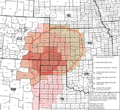
Area affected by the Dust Bowl between 1935 and 1938
.svg)
See also
 In Spanish: Boise City (Oklahoma) para niños
