Imperial, Nebraska facts for kids
Quick facts for kids
Imperial, Nebraska
|
|
|---|---|

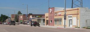
Downtown Imperial: Broadway, looking north
|
|

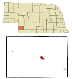
Location within Chase County and Nebraska
|
|
| Country | United States |
| State | Nebraska |
| County | Chase |
| Area | |
| • Total | 3.03 sq mi (7.85 km2) |
| • Land | 3.02 sq mi (7.83 km2) |
| • Water | 0.01 sq mi (0.01 km2) |
| Elevation | 3,278 ft (999 m) |
| Population
(2020)
|
|
| • Total | 2,068 |
| • Density | 683.64/sq mi (263.95/km2) |
| Time zone | UTC-7 (Mountain (MST)) |
| • Summer (DST) | UTC-6 (MDT) |
| ZIP code |
69033
|
| Area code(s) | 308 |
| FIPS code | 31-23690 |
| GNIS feature ID | 2394466 |
| Website | imperial-ne.com |
Imperial is a city located in Chase County, Nebraska, in the United States. It is the main town and the county seat of Chase County. In 2010, about 2,071 people lived there.
Contents
History
Imperial started on land claimed by two men, Thomas Mercier and M. J. Goodrich. They offered free land lots to anyone who would build a house or business. This helped the town grow quickly. Thomas Mercier became the first postmaster in December 1885.
The railroad was a big deal for Imperial. Tracks were laid towards the town in 1888. On August 15, 1892, the railroad finally reached Imperial. This line was built by a part of the Chicago, Burlington and Quincy Railroad. It connected Imperial to a main line near Culbertson.
When the railroad was finished, a company called Lincoln Land Company offered new land lots. These were closer to the new railroad line. Most of the buildings in town were moved south to this new area. This is where the main business district of Imperial is today.
Imperial's first courthouse was built in 1889. It stood on the same spot where the current courthouse is now.
Historic Places in Imperial
Some buildings in Imperial are very old and important. They are listed on the National Register of Historic Places.
- The Balcony House was added to the list in 2000. You can find it at 10th and Court Streets.
- The Chase County Court House was listed in 1990. It is on Broadway between 9th and 10th Streets.
Geography
Imperial covers a total area of about 2.95 square miles (7.64 square kilometers). All of this area is land.
Demographics
Imperial has seen its population grow over the years. Here is how the number of people living in Imperial has changed:
| Historical population | |||
|---|---|---|---|
| Census | Pop. | %± | |
| 1890 | 159 | — | |
| 1900 | 258 | 62.3% | |
| 1910 | 402 | 55.8% | |
| 1920 | 723 | 79.9% | |
| 1930 | 946 | 30.8% | |
| 1940 | 1,195 | 26.3% | |
| 1950 | 1,563 | 30.8% | |
| 1960 | 1,423 | −9.0% | |
| 1970 | 1,589 | 11.7% | |
| 1980 | 1,941 | 22.2% | |
| 1990 | 2,007 | 3.4% | |
| 2000 | 1,982 | −1.2% | |
| 2010 | 2,071 | 4.5% | |
| 2020 | 2,068 | −0.1% | |
| U.S. Decennial Census 2013 Estimate |
|||
Imperial's Population in 2010
In 2010, there were 2,071 people living in Imperial. These people lived in 860 households. A household is a group of people living in one home. About 553 of these were families. The city had about 702 people per square mile.
Most people in Imperial were White (88.3%). About 9.6% were from other racial backgrounds. About 15.4% of the population identified as Hispanic or Latino.
About 30.3% of households had children under 18 living with them. More than half (52.0%) were married couples. Some households had a single parent. About 31.4% of all households were made up of just one person. About 16% of households had someone aged 65 or older living alone.
The average age in Imperial was 41 years old. About 25.2% of residents were under 18. About 19.2% were 65 or older. The population was almost evenly split between males (48.9%) and females (51.1%).
Notable people
- Warren Prall Watters, who helped start the Free Church of Antioch, was born in Imperial.
See also
 In Spanish: Imperial (Nebraska) para niños
 | Janet Taylor Pickett |
 | Synthia Saint James |
 | Howardena Pindell |
 | Faith Ringgold |

