
Atwood, Colorado facts for kids
Quick facts for kids
Atwood, Colorado
|
|
|---|---|

Entering Atwood from the southwest along U.S. Route 6
|
|

Location of the Atwood CDP in Logan County, Colorado.
|
|

Atwood, Colorado
Location in the United States
|
|
| Country | |
| State | |
| County | Logan County |
| Government | |
| • Type | unincorporated town |
| Area | |
| • Total | 1.034 sq mi (2.678 km2) |
| • Land | 1.034 sq mi (2.678 km2) |
| • Water | 0 sq mi (0.000 km2) |
| Elevation | 4,003 ft (1,220 m) |
| Population
(2020)
|
|
| • Total | 138 |
| • Density | 133.5/sq mi (51.53/km2) |
| Time zone | UTC-7 (MST) |
| • Summer (DST) | UTC-6 (MDT) |
| ZIP Code |
80722
|
| Area code(s) | 970 |
| GNIS feature | Atwood CDP |
Atwood is a small community in Logan County, Colorado, United States. It is called an "unincorporated town" because it does not have its own local government. It is also a "census-designated place" (CDP), which means the United States Census Bureau has defined it for gathering population data.
Atwood has its own post office with the ZIP Code 80722. In 2020, about 138 people lived in Atwood.
Contents
History of Atwood
The Atwood post office opened its doors in 1885. The community was named after John Atwood. He was a Unitarian minister.
Geography and Location
Atwood is found in the southwestern part of Logan County. U.S. Route 6 goes right through the community. This road leads northeast about 7 miles (11 km) to Sterling. Sterling is the main town, or county seat, of Logan County.
The same road, U.S. Route 6, also goes southwest about 6 miles (10 km) to Merino. Another road, Colorado State Highway 63, goes south from Atwood. It leads to Interstate 76 and further to Akron.
The total area of Atwood is about 1.03 square miles (2.678 square kilometers). All of this area is land.
Atwood's Climate
Atwood has a climate that is called "semi-arid steppe." This means it's not quite a desert, but it is still very dry. It gets more rain than a desert, but not enough to be a lush, green area.
The weather here is often sunny. Summers are warm, and winters are cold. The Köppen Climate Classification system calls this type of climate "BSk." This stands for a "Tropical and Subtropical Steppe Climate."
| Climate data for Atwood, Colorado | |||||||||||||
|---|---|---|---|---|---|---|---|---|---|---|---|---|---|
| Month | Jan | Feb | Mar | Apr | May | Jun | Jul | Aug | Sep | Oct | Nov | Dec | Year |
| Mean daily maximum °C (°F) | 4 (39) |
6 (43) |
11 (51) |
16 (60) |
21 (70) |
27 (81) |
31 (88) |
31 (87) |
26 (78) |
18 (65) |
10 (50) |
4 (40) |
17 (63) |
| Mean daily minimum °C (°F) | −10 (14) |
−8 (17) |
−4 (24) |
1 (33) |
6 (43) |
11 (52) |
14 (58) |
14 (57) |
9 (48) |
2 (36) |
−4 (24) |
−9 (16) |
2 (35) |
| Average precipitation mm (inches) | 10 (0.4) |
13 (0.5) |
28 (1.1) |
51 (2) |
71 (2.8) |
66 (2.6) |
66 (2.6) |
53 (2.1) |
30 (1.2) |
25 (1) |
15 (0.6) |
13 (0.5) |
440 (17.4) |
| Source: Weatherbase | |||||||||||||
Population Changes Over Time
The United States Census Bureau first officially counted Atwood as a CDP in 2000. This means they started tracking its population separately then.
| Atwood CDP, Colorado | ||
|---|---|---|
| Year | Pop. | ±% |
| 2000 | 195 | — |
| 2010 | 133 | −31.8% |
| 2020 | 138 | +3.8% |
| Source: United States Census Bureau | ||
Images for kids
-
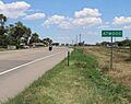
Entering Atwood from the southwest along U.S. Route 6
-
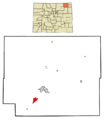
Location of the Atwood CDP in Logan County, Colorado.
See also
 In Spanish: Atwood (Colorado) para niños
