Littleton, Colorado facts for kids
Quick facts for kids
Littleton, Colorado
|
|
|---|---|

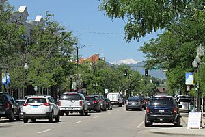
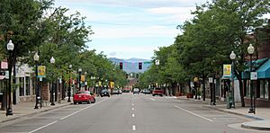
Downtown Littleton, 2015.
|
|

|
|
| Country | |
| State | |
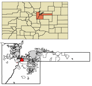
| Counties | Arapahoe County Douglas County Jefferson County |
| City | Littleton |
| Settled | 1862 |
| Incorporated | March 13, 1890 |
| Named for | Richard Little |
| Government | |
| • Type | Council–manager government |
| Area | |
| • Total | 35.63 km2 (13.75 sq mi) |
| • Land | 32.69 km2 (12.62 sq mi) |
| • Water | 2.93 km2 (1.13 sq mi) |
| Elevation | 1,645 m (5,397 ft) |
| Population
(2020)
|
|
| • Total | 45,652 |
| • Density | 1,281.92/km2 (3,320.15/sq mi) |
| Time zone | UTC−7 (MST) |
| • Summer (DST) | UTC−6 (MDT) |
| ZIP codes |
80120-80130, 80160-80163 (PO Boxes), 80165, 80166
|
| Area code(s) | Both 303 and 720 |
| FIPS code | 08-45255 |
| GNIS feature ID | 2410845 |
| Highways | US 85, SH 75, SH 88, SH 470 |
| Website | littletonco.gov/ |
Littleton is a city in Colorado, United States. It is a "home rule municipality," which means it has special powers to govern itself. Littleton is located across three counties: Arapahoe, Douglas, and Jefferson. It is the main city, or "county seat," for Arapahoe County. Littleton is also part of the larger Denver metropolitan area. In 2020, about 45,652 people lived in Littleton, making it the 20th largest city in Colorado.
Contents
History of Littleton
The story of Littleton began in 1859 during the Pike's Peak gold rush. This event brought many people, including farmers and merchants, to the area. Richard Sullivan Little, an engineer from New Hampshire, came to work on irrigation systems. He decided to settle in the area that is now Littleton. In 1862, his wife Angeline joined him.
The Littles and their neighbors built the Rough and Ready Flour Mill in 1867. This mill helped the community grow and become strong. By 1890, 245 people lived there, and they voted to officially make it the Town of Littleton.
Littleton grew a lot in the 1950s and 1960s. This was partly because it was close to Denver. Also, the Martin Marietta company built facilities nearby. They made important aerospace products like the Titan rocket. Today, Littleton is a big part of the Denver metropolitan area.
In 1961, Littleton became a "sister city" with Bega, Australia. This was one of the first sister city partnerships.
Littleton became widely known in 1999 because of a tragic event at Columbine High School. News reports often said the event happened in Littleton. However, the school is actually in Columbine, which is an unincorporated community. This means it's not an official city. The school's ZIP code is linked to Littleton, so mail uses "Littleton" in the address. Columbine High School is part of the Jefferson County school system, not the Littleton Public Schools.
Geography and Climate
Littleton is in central Colorado. It is about 9 miles (14 km) south of downtown Denver. It is also about 55 miles (89 km) north of Colorado Springs.
The city sits along the South Platte River. This area is part of the Colorado Piedmont region, which is near the Front Range of the Southern Rocky Mountains. Most of Littleton is on the east side of the river. Several small streams, like Big Dry Creek and Lee Gulch, flow through the city. There are also several small lakes and reservoirs near the river. Chatfield Reservoir is just southwest of the city.
The city covers about 13.87 square miles (35.92 km2). About 12.98 square miles (33.62 km2) is land, and 0.89 square miles (2.31 km2) is water.
Littleton is a suburb of Denver. It shares borders with several other cities and communities. These include Denver and Englewood to the north, Centennial to the east, and Highlands Ranch to the south.
Littleton's Weather
Littleton has a climate with warm summers and cold winters. The highest temperature ever recorded was 99°F (37°C) in July and August. The lowest was -29°F (-34°C) in December. The city gets about 16.39 inches (41.6 cm) of rain each year. It also gets a good amount of snow, averaging about 65.7 inches (167 cm) per year.
People of Littleton
| Historical population | |||
|---|---|---|---|
| Census | Pop. | %± | |
| 1880 | 100 | — | |
| 1900 | 738 | — | |
| 1910 | 1,373 | 86.0% | |
| 1920 | 1,636 | 19.2% | |
| 1930 | 2,019 | 23.4% | |
| 1940 | 2,244 | 11.1% | |
| 1950 | 3,378 | 50.5% | |
| 1960 | 13,670 | 304.7% | |
| 1970 | 26,466 | 93.6% | |
| 1980 | 28,631 | 8.2% | |
| 1990 | 33,685 | 17.7% | |
| 2000 | 40,340 | 19.8% | |
| 2010 | 41,737 | 3.5% | |
| 2020 | 45,652 | 9.4% | |
| 2024 (est.) | 44,879 | 7.5% | |
| U.S. Decennial Census | |||
In 2020, Littleton had 45,652 people living in 20,300 homes. The city's population density was about 3,215 people per square mile. Most residents, about 83.1%, were White. About 12.6% of the population identified as Hispanic or Latino.
In 2023, about 18.5% of households had children under 18. The average household size was 2.19 people. The median age in the city was 40.2 years. About 18.5% of the population was under 18.
The median income for a household in Littleton was $96,611. For families, it was $130,080. The average income per person was $126,140. About 6.3% of the population lived below the poverty line.
Economy and Jobs
In 2023, about 68% of people over 16 were working. Many people in Littleton work in management, business, science, and arts. Other common jobs are in sales, office work, and service industries. The biggest industries are education, healthcare, and social assistance. Professional services and finance are also important.
The cost of living in Littleton is about average compared to the rest of the U.S. In 2023, the median value for a home was $596,700. Rent for a home was about $1,731 per month.
City Government
Littleton has a "council-manager" form of government. This means the city council makes the rules and approves the budget. A city manager then carries out these rules and manages the city's daily operations.
Littleton is the "county seat" of Arapahoe County. This means the main offices for the county government are located here.
Most of Littleton is in Colorado's 6th U.S. Congressional District. A small part is in the 1st congressional district. For state government, Littleton is in several different districts for the Colorado Senate and the Colorado House of Representatives.
Elected Leaders
The city council has seven members. There is one member for each of the four districts. There are also two members who represent the whole city, called "at-large" members. The mayor is also part of the council. Since 2021, all council members are elected for four-year terms. Elections happen every two years in odd-numbered years. In 2021, Littleton voters elected their first mayor to a four-year term.
| Member | District | Term |
|---|---|---|
| Kyle Schlachter | Mayor (At Large) | 2021-2025 |
| Joel Zink* | At Large | 2025* |
| Pam Grove | At Large | 2023-2027 |
| Patrick Driscoll | District 1 | 2021-2025 |
| Robert Reichardt | District 2 | 2023-2027 |
| Stephen Barr | District 3 | 2021-2025 |
| Andrea Peters | District 4 | 2023-2027 |
*Joel Zink was appointed to fill a spot when Council Member Gretchen Rydin left. His term ends in November 2025.
Education in Littleton
Most of Littleton is served by Littleton Public Schools. Some smaller parts of the city are in the Sheridan School District 2 and Englewood School District 1.
The parts of Littleton in Jefferson County are in Jeffco Public Schools. The small part in Douglas County is in Douglas County School District RE-1.
Colleges and Universities
Littleton is home to two colleges:
- Arapahoe Community College
- Denver Seminary
The Colorado Center for the Blind is also in Littleton. This program helps blind teenagers and adults learn important skills.
Getting Around Littleton
Highways
Four main highways pass through Littleton:
 US 85 (South Santa Fe Drive) is the longest highway in the city. It runs from the northern border with Englewood to the southern border with Highlands Ranch.
 State Highway 75 (South Platte Canyon Road) starts in Littleton and goes south.
 State Highway 88 (East Belleview Avenue) runs near the northern edge of the city.
 State Highway 470 runs along the southern edge of the city.
Public Transportation
The Regional Transportation District offers bus and light rail services in Littleton. Light rail service began in 2000. There are two light rail stations in the city: Littleton-Downtown station and Littleton-Mineral station. The Mineral station is the last stop on the D Line.
Culture and Fun in Littleton

Arts and Music
Littleton has many places for arts and music:
- Town Hall Arts Center
- The Depot Art Gallery and Littleton Fine Arts Guild
- Littleton Symphony Orchestra
- Voices West (a choir group)
- Littleton Museum
- SpaceX Falcon 9 booster (a rocket part on display)
Events in Littleton
Western Welcome Week Since the 1920s, Littleton has celebrated Western Welcome Week. This is an annual community event with over 40 activities. These events help local groups and charities.
Candlelight Walk The Candlelight Walk is a special holiday tradition in Littleton. It's an evening of festive activities that ends with the lighting of trees on Main Street.
Twilight Criterium
The Littleton Twilight Criterium is a bike race held in late summer. It takes place in Historic Downtown Littleton on a 0.8-mile course. The event features famous athletes, concerts, and a fun ride for everyone.
Healthcare
The main hospital in Littleton is AdventHealth Littleton.
Places to Visit
- Hudson Gardens
- Town Hall Arts Center, which offers professional theater.
- The Littleton Museum
- Gravesite of Alfred (Alferd) Packer
Sister City
Littleton has one sister city:
 Bega, New South Wales, Australia
See also
 In Spanish: Littleton (Colorado) para niños
- List of municipalities in Colorado
- List of statistical areas in Colorado
- List of people from Littleton, Colorado
 | DeHart Hubbard |
 | Wilma Rudolph |
 | Jesse Owens |
 | Jackie Joyner-Kersee |
 | Major Taylor |


