
Ulaanbaatar facts for kids
Quick facts for kids
Ulaanbaatar
Улаанбаатар
ᠤᠯᠠᠭᠠᠨᠪᠠᠭᠠᠲᠤᠷ |
|||
|---|---|---|---|
|
City centre with Sükhbaatar Square
Gandantegchinlen Monastery
Choijin Lama Temple
Ger districts
Ugsarmal panel buildings built in the socialist era
National University of Mongolia
Naadam ceremony at the National Sports Stadium
|
|||
|
|||
| Nickname(s):
УБ (UB), Нийслэл (capital), Хот (city)
|
|||

Ulaanbaatar highlighted in Mongolia
|
|||

Ulaanbaatar
Location in Mongolia

Ulaanbaatar
Location in Asia
|
|||
| Country | |||
| Monastic center established | 1639 | ||
| Final location | 1778 | ||
| Named Ulaanbaatar | 1924 | ||
| Government | |||
| • Type | Council–Manager | ||
| • Body | Citizens' Representatives Khural of the Capital City | ||
| Area | |||
| • Total | 4,704 km2 (1,816 sq mi) | ||
| Elevation | 1,350 m (4,429 ft) | ||
| Population
(2021)
|
|||
| • Total | 1,672,627 | ||
| • Density | 311/km2 (807/sq mi) | ||
| GDP | |||
| • Total | MNT 45,047 billion US$ 13.2 billion (2023) |
||
| • Per capita | MNT 27,455,175 US$ 8,049 (2023) |
||
| Time zone | UTC+08:00 (H) | ||
| Postal code |
210 xxx
|
||
| Area code(s) | +976 (0)11 | ||
| HDI (2018) | 0.810 – very high · 1st | ||
| License plate | УБ, УН | ||
| ISO 3166-2 | MN-1 | ||
| Climate | BSk | ||

.jpg)


.jpg)


Ulaanbaatar (/ʊˌlɑːn ˈbɑːtər/; Mongolian: Улаанбаатар, pronounced [ʊˌɮaːɴ‿ˈpaːʰtə̆r], meaning Red Hero) is the capital city of Mongolia. It is also the largest city in the country. About 1.6 million people live here, making it home to almost half of Mongolia's population. Ulaanbaatar is known as the coldest capital city in the world. This is because of its very low average yearly temperature.
The city is located in north-central Mongolia. It sits in a valley by the Tuul River, about 1,300 meters (4,265 feet) above sea level. Ulaanbaatar started as a traveling Buddhist center in 1639. It moved 28 times before settling in its current spot in 1778.
In its early days, the city was called Örgöö (or Urga). It became a very important religious place in Mongolia. It was the home of the Jebtsundamba Khutuktu, a spiritual leader in Tibetan Buddhism. After a trade agreement in 1727, a trade route opened between Beijing and Kyakhta. The city eventually settled along this route.
Ulaanbaatar played a big part in Mongolia gaining its independence. This happened in 1911 and again during the communist revolution in 1921. In 1924, the city was officially named Ulaanbaatar. It was declared the capital of the new Mongolian People's Republic. Modern city planning began in the 1950s. Many old areas with traditional ger tents were replaced by Soviet-style apartment buildings.
In 1990, Ulaanbaatar was the site of large protests. These protests led to Mongolia becoming a democracy and having a market economy. Since 1990, many people have moved to Ulaanbaatar from other parts of Mongolia. This has caused the city's population to grow very quickly. Many new residents live in ger districts. These areas often lack proper heating and services. This has led to serious air pollution problems in winter.
Ulaanbaatar is like its own special area, separate from the Töv Province that surrounds it. It is Mongolia's main city for culture, industry, and money. It is also the center of the country's transport system.
Contents
- Discovering Ulaanbaatar's Names
- Journey Through Ulaanbaatar's Past
- Ulaanbaatar's Location and Weather
- People and Culture in Ulaanbaatar
- Learning and Libraries in Ulaanbaatar
- Sports and Fun in Ulaanbaatar
- City Life and Services
- Air Pollution in Ulaanbaatar
- Ulaanbaatar's Sister Cities
- Images for kids
- See also
Discovering Ulaanbaatar's Names
The city has had many names throughout its history. When it was founded in 1639, it was called Örgöö. This name means "Palace" or "Yurt Palace." Westerners later called it Urga.
Over time, it got other names:
- Nomiĭn Khüree (meaning "Khüree of Wisdom") by 1651.
- Ikh Khüree (meaning "Great Khüree") by 1706. The Chinese called it Dà Kùlún, which also means "Great Kùlún."
- Bogdiin Khuree (meaning "The Bogd's Khüree").
- Simply Khüree, which means "enclosure" or "settlement."
When Mongolia became independent in 1911, the city's name changed to Niĭslel Khüree. This means "Capital Khüree."
On October 29, 1924, the city became the capital of the new Mongolian People's Republic. Its name was changed to Ulaanbaatar, which means "Red Hero." In the West, it was often spelled Ulan Bator, based on the Russian spelling.
Journey Through Ulaanbaatar's Past
Ancient Times in Ulaanbaatar
People have lived in the Ulaanbaatar area since the Stone Age. Tools found here are from as far back as 300,000 years ago. These early people hunted large animals like mammoths.

Ancient royal tombs have been found around Ulaanbaatar. The city's location on the Tuul River made it important for nomadic empires. It is believed that Wang Khan, a famous leader, had his palace here. Even Genghis Khan is said to have stayed here before a battle in 1226.
The area was a key stop on the route from the old capital, Karakorum, to the holy Khentii Mountains. This made the Bogd Khan Mountain a protected and important place from early times.
The Traveling Monastery City
Ulaanbaatar began in 1639 as a monastery town called Örgöö. It was a collection of yurts (traditional tents). It was first located near Lake Shireet Tsagaan nuur. The Mongol nobles wanted it to be the home of Zanabazar, the first spiritual leader of Mongolia.
Because it was a mobile monastery, Örgöö often moved. It traveled along the Selenge, Orkhon, and Tuul rivers. It even moved to Inner Mongolia during wars. As the city grew, it moved less often.
In 1778, the city finally settled in its current location. This spot is near where the Selbe and Tuul rivers meet. It is also at the foot of Bogd Khan Uul mountain. This location was also on the important trade route from Beijing to Kyakhta.
By 1723, Örgöö was the most important monastery in Mongolia. It also became a major trading center for Outer Mongolia. In 1758, the Chinese emperor appointed officials to oversee the city. This made Urga the highest civil authority in the country.

By 1778, Urga had many monks, perhaps as many as ten thousand. They followed strict rules. For example, in 1797, a rule said no singing, archery, chess, or smoking. Executions were not allowed where the holy temples could be seen.
In 1839, the main spiritual leader moved his home to Gandan Hill. The Gandan Monastery became a famous place for learning.

Trade and Growth in Urga
After a treaty in 1727, Urga became a key point for trade between Russia and China. Furs from Siberia were traded for Chinese cloth and tea. Goods from further west also came to Urga. From here, they were sent to China or Russia.
By 1908, there was a Russian area in the city. It had merchants, a club, and a church. There was also a Chinese trading post nearby. As Western trade grew in Chinese ports, the tea trade to Russia slowed down. Wool became the main export from Urga.
In 1910, a fight broke out between monks and Chinese traders. The Chinese official could not control the monks and had to leave.

The city's population grew a lot during the Naadam festival and other religious events. In 1919, there were 20,000 monks living in the city.
Independence and a New Name

In 1911, Chinese rule was ending. Mongolian leaders in Ikh Khüree secretly decided to become independent. On December 29, 1911, the Bogd Khan was declared the ruler of an independent Mongolia. Khüree became the capital of this new state.
In 1919, Chinese troops took over Khüree. But in 1921, a mixed Russian and Mongolian force, led by a White Russian general, captured the city. They freed the Bogd Khan. Later, a Soviet-supported Mongolian force took control. On October 29, 1924, the city was renamed Ulaanbaatar, meaning "Red Hero City."
Ulaanbaatar in Modern Times

During the time Mongolia was a socialist country, many old ger districts were replaced. New apartment buildings, often funded by the Soviet Union, were built. City planning started in the 1950s. Much of the city center today was built between 1960 and 1985.
The Trans-Mongolian Railway, connecting Ulaanbaatar to Moscow and Beijing, was finished in 1956. Many old temples and monasteries were destroyed in the 1930s. However, the Gandan monastery was reopened in 1944.

Ulaanbaatar was a key place for protests in 1990. These protests led to Mongolia becoming a democracy. Since 1990, the city has grown very fast. Its population went from 535,000 in 1990 to 1.5 million by 2021. Many people moved from rural areas to find new opportunities. A large number of these new residents live in ger districts. These areas often lack modern services like plumbing and central heating. This rapid growth has caused problems with city services and pollution.
In 2008, there were riots in Ulaanbaatar after a parliamentary election. This was the first time such a deadly riot happened in the city.
A new airport, Chinggis Khaan International Airport, opened in Ulaanbaatar in 2021. Since the 2010s, many new tall buildings have been built in the city.
Protecting Historic Buildings
Since 2013, some historic buildings in Ulaanbaatar have been torn down. This has happened even though many people wanted them saved. These include museums and university buildings. In 2019, there were plans to demolish more historic buildings. But public outcry and architects' protests helped save some of them.
Ulaanbaatar's Location and Weather
Where is Ulaanbaatar Located?

Ulaanbaatar is about 1,350 meters (4,429 feet) above sea level. It is slightly east of the center of Mongolia. The city lies in a valley by the Tuul River. This river is part of the Selenge river system. The valley is at the foot of the Bogd Khan Uul mountain. This mountain is covered in thick forests and rises to 2,250 meters (7,382 feet). It separates the dry steppe lands to the south from the forest-steppe to the north.
Four peaks are said to surround Ulaanbaatar: Songino Khairkhan, Chingeltei, Bayanzurkh, and Bogd Khan Uul. The forests around the city have evergreen pines, larches, and birches. Along the Tuul River, you can find poplars, elms, and willows. Ulaanbaatar is at a similar latitude to cities like Vienna and Seattle.
Ulaanbaatar's Climate: The Coldest Capital
Ulaanbaatar has a very cold climate. This is due to its high elevation, its distance from any ocean, and the effects of the Siberian winds. It is the coldest national capital in the world.
The city has short, warm summers. Its winters are long, very cold, and dry. In January, the coldest month, temperatures can drop to between -36°C and -40°C (-33°F and -40°F). Most of the rain falls from May to September.
Ulaanbaatar's average yearly temperature is about 0.2°C (32.4°F). This makes it the coldest capital. Even though it gets quite warm from late April to early October, the very cold winters bring the average down. The city is in an area where the ground can stay frozen for most of the year. This makes building difficult in some places. Traditional yurts used by suburban residents do not go deep into the soil. The highest temperature ever recorded was 39.0°C (102.2°F) in July 1988. The lowest was -43.9°C (-47.0°F) in January 1957.
| Climate data for Ulaanbaatar (1991-2020, extremes 1869-present) | |||||||||||||
|---|---|---|---|---|---|---|---|---|---|---|---|---|---|
| Month | Jan | Feb | Mar | Apr | May | Jun | Jul | Aug | Sep | Oct | Nov | Dec | Year |
| Record high °C (°F) | 0.0 (32.0) |
11.3 (52.3) |
18.9 (66.0) |
28.7 (83.7) |
33.5 (92.3) |
38.3 (100.9) |
39.0 (102.2) |
36.7 (98.1) |
31.7 (89.1) |
22.5 (72.5) |
13.0 (55.4) |
6.1 (43.0) |
39.0 (102.2) |
| Mean daily maximum °C (°F) | −15.5 (4.1) |
−9.4 (15.1) |
−0.2 (31.6) |
10.4 (50.7) |
17.8 (64.0) |
23.1 (73.6) |
25.2 (77.4) |
23.0 (73.4) |
17.2 (63.0) |
7.7 (45.9) |
−4.8 (23.4) |
−13.7 (7.3) |
6.7 (44.1) |
| Daily mean °C (°F) | −21.3 (−6.3) |
−16.3 (2.7) |
−6.7 (19.9) |
3.0 (37.4) |
10.2 (50.4) |
16.5 (61.7) |
19.0 (66.2) |
16.6 (61.9) |
10.0 (50.0) |
0.9 (33.6) |
−10.6 (12.9) |
−19.0 (−2.2) |
0.2 (32.4) |
| Mean daily minimum °C (°F) | −25.6 (−14.1) |
−21.7 (−7.1) |
−12.6 (9.3) |
−3.3 (26.1) |
3.5 (38.3) |
10.3 (50.5) |
13.5 (56.3) |
11.1 (52.0) |
4.1 (39.4) |
−4.5 (23.9) |
−15.1 (4.8) |
−22.9 (−9.2) |
−5.3 (22.5) |
| Record low °C (°F) | −43.9 (−47.0) |
−42.2 (−44.0) |
−37.2 (−35.0) |
−26.1 (−15.0) |
−16.1 (3.0) |
−3.9 (25.0) |
−0.2 (31.6) |
−2.8 (27.0) |
−13.4 (7.9) |
−20.0 (−4.0) |
−35.0 (−31.0) |
−42.2 (−44.0) |
−43.9 (−47.0) |
| Average precipitation mm (inches) | 2.1 (0.08) |
2.8 (0.11) |
4.6 (0.18) |
8.4 (0.33) |
21.7 (0.85) |
47.2 (1.86) |
74.5 (2.93) |
65.4 (2.57) |
27.9 (1.10) |
8.6 (0.34) |
6.3 (0.25) |
3.5 (0.14) |
273 (10.74) |
| Average precipitation days (≥ 1.0 mm) | 1.3 | 1.6 | 1.8 | 2.5 | 3.7 | 6.7 | 9.9 | 8.8 | 4.9 | 2.1 | 2.8 | 1.7 | 47.8 |
| Average rainy days | 0 | 0 | 0.3 | 3 | 8 | 14 | 17 | 15 | 9 | 2 | 0.1 | 0 | 68 |
| Average snowy days | 10 | 7 | 7 | 6 | 4 | 0.1 | 0 | 0 | 2 | 6 | 9 | 11 | 62 |
| Average relative humidity (%) | 74.7 | 69.5 | 57.6 | 44.2 | 42.7 | 50.1 | 58.2 | 60.8 | 56.1 | 56.9 | 68.3 | 75.1 | 62 |
| Mean monthly sunshine hours | 164.2 | 203.5 | 257.4 | 265.3 | 297.9 | 282.3 | 278.3 | 265.2 | 249.5 | 227.6 | 175.4 | 137.7 | 2,804.3 |
| Source 1: Pogoda.ru.net | |||||||||||||
| Source 2: NOAA(humidity-sun) | |||||||||||||
| Climate data for Buyant-Ukhaa International Airport weather station (WMO identifier: 44291) (between 1991-2020) | |||||||||||||
|---|---|---|---|---|---|---|---|---|---|---|---|---|---|
| Month | Jan | Feb | Mar | Apr | May | Jun | Jul | Aug | Sep | Oct | Nov | Dec | Year |
| Average dew point °C (°F) | −24.7 (−12.5) |
−20.9 (−5.6) |
−14.5 (5.9) |
−9.6 (14.7) |
−3.8 (25.2) |
4.5 (40.1) |
9.4 (48.9) |
7.9 (46.2) |
0.5 (32.9) |
−7.6 (18.3) |
−15.7 (3.7) |
−22.6 (−8.7) |
−8.1 (17.4) |
| Source: [1] | |||||||||||||
City's Look and Feel

The heart of Ulaanbaatar has buildings from the 1940s and 1950s. These are in a Soviet style. Around them are modern concrete apartment blocks. There are also many large ger districts. After communism ended, many ground floors of apartment blocks became small shops. Many new buildings have also been built, some without proper permits. Since the 2010s, there has been a building boom. Many tall apartment and office buildings have appeared.
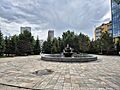
Sükhbaatar Square is the main center of Ulaanbaatar. It has a statue of the revolutionary hero Damdin Sükhbaatar on horseback. On the north side is the Government Palace. Peace Avenue, the main road, runs along the south side of the square.
Important places to visit include the Gandantegchinlen Monastery. There is also the socialist monument at Zaisan Memorial, which offers great city views. Other landmarks are the Bogd Khan's Winter Palace and the Choijin Lama Temple. The tallest building in Mongolia is the Shangri-La Hotel complex.
Popular shopping areas include the 3rd Microdistrict Boulevard. Peace Avenue around the State Department Store is also busy. The Narantuul "Black Market" area is another big market.
Ulaanbaatar has many cinemas, a ski resort, and indoor stadiums. There are also large department stores and an amusement park. You can find many types of food, entertainment, and fun places. Big international food chains like KFC and Burger King have opened here. Hotel chains like Ramada and Shangri-La are also in the city.
Green Spaces and Parks

Several national parks and protected areas are part of the city. Gorkhi-Terelj National Park is a nature preserve with many tourist spots. It is about 70 km (43 miles) from Ulaanbaatar. The 40-meter (131-foot) tall Genghis Khan Equestrian Statue is 54 km (34 miles) east of the city. The city is also close to Hustai National Park. This park is home to the wild Takhi horses.
Bogd Khan Uul is a strictly protected area to the south. It is 31 km (19 miles) long and 3 km (1.9 miles) wide. Protecting nature here dates back to the 12th and 13th centuries. The ruins of Manjusri Monastery are on the south side of Bogd Khan Uul. It is a popular place for outings.
The National Amusement Park is in the downtown area. It has rides, games, and paddle boats. Its original lake castle was built in 1969.
The National Garden Park opened in 2009. It is on the southeastern edge of the city. It has 55 hectares (136 acres) and over 100,000 trees. The park aims to teach people about healthy living and protecting the environment.
People and Culture in Ulaanbaatar
Population and Living Areas

| Historical population | ||
|---|---|---|
| Year | Pop. | ±% |
| 1950 | 69,951 | — |
| 1960 | 179,063 | +156.0% |
| 1970 | 297,615 | +66.2% |
| 1979 | 396,300 | +33.2% |
| 1989 | 540,300 | +36.3% |
| 2000 | 760,077 | +40.7% |
| 2010 | 1,089,358 | +43.3% |
| 2020 | 1,395,773 | +28.1% |
Ulaanbaatar is the main city in Mongolia. Many people from rural areas move here. The population has grown very fast. In 1979, it had 400,000 people. By 2007, it reached 1 million. In 2020, the population was 1,466,125.
Two-thirds of the city's residents live in ger districts. These areas often lack good infrastructure, sanitation, and public services. Most people in Ulaanbaatar were born in the city. In 2020, about 17,456 people living in the city were born in other countries.
Beliefs and Religions
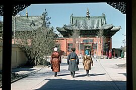
Ulaanbaatar has a long history with Buddhism. It started as a center for monks. Important Buddhist places include the Gandantegchinlen Monastery and Choijin Lama Temple. Today, it is a city with many different faiths. There are Christian churches, like the Orthodox Holy Trinity Church. There is also the Catholic Saints Peter and Paul Cathedral and Islamic mosques.
A 2020 survey showed that 46.3% of people over 15 years old said they had no religion. Of those who were religious, most were Buddhist (89.1%). Others followed Shamanism (5.4%), Christianity (3.3%), and Islam (0.9%).
Arts and Entertainment

Ulaanbaatar has both traditional and modern theaters. Many Mongolian folklore bands perform around the world. The Ulaanbaatar Opera House hosts concerts, opera, and ballet.
The Mongolian State Grand National Orchestra started in 1945. It has the largest orchestra of traditional instruments in the country. They play both Mongolian and international music.
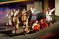
The Tumen Ekh Ensemble performs all types of Mongolian song, music, and dance. They use traditional instruments like the morin khuur (horsehead fiddle). They also perform long songs, epic songs, and traditional dances.
The Morin Khuur Ensemble of Mongolia is part of the Mongolian State Philharmonic. They focus on the national string instrument, the morin khuur.
Monasteries to Explore

The Choijin Lama Monastery is an important old Buddhist monastery. It was finished in 1908. It was saved from destruction by being turned into a museum in 1942.
The Gandan Monastery dates back to the 19th century. Its most famous feature is a 26.5-meter (87-foot) tall golden statue of Migjid Janraisig. These monasteries are among the few that survived the destruction of monasteries in Mongolia in the 1930s.
Museums to Visit

Ulaanbaatar has many museums about Mongolian history and culture. The Natural History Museum has many dinosaur fossils found in Mongolia.
The National Museum of Mongolia shows exhibits from ancient times to today. This includes the Mongol Empire. The Zanabazar Museum of Fine Arts has a large collection of Mongolian art. This includes works by the 17th-century artist Zanabazar. It also has Mongolia's most famous painting, One Day In Mongolia.
The Military Museum of Mongolia shows the country's war history. You can see tools and weapons from ancient times to modern peacekeeping missions.
The city's museum shows Ulaanbaatar's history through old maps and photos. It has a huge painting of the capital from 1912. The Mongolian Railway History Museum is an outdoor museum. It shows different types of trains used in Mongolia.
The Puzzle Toys Museum has a collection of wooden toys that visitors can put together.
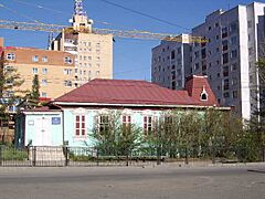
The Victims of Political Persecution Memorial Museum told the story of a sad time in Mongolia's history. It was dedicated to those who suffered during the Communist purges in the 1930s. This small building was torn down in 2019, despite public protests.
-
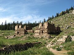
Ruins of the Tsogchin Temple (1749) of Manjusri Monastery.
-
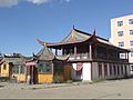
A building of the Dambadarjaalin Monastery (1765) in Sukhbaatar District.
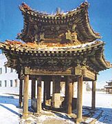
-
Vajradhara Temple (1841) in the center, Zuu Temple (1869) on the left.
-
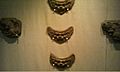
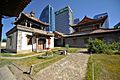
Winter residence of the Bogd Gegeen, built in 1903.
-
Zanabazar's Fine Arts Museum, built in 1905.
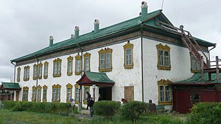
-
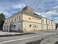
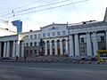
Ulaanbaatar History Museum, built in 1904.
-
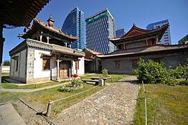
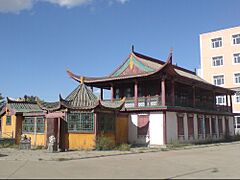
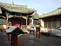
Choijin Lama Temple complex, built in 1904–1908.
-

West Geser Temple, built in 1919–1920.
-
Residence of Prince Chin Wang Khanddorj, built in 1913.
.jpg)


Learning and Libraries in Ulaanbaatar
Universities and Schools

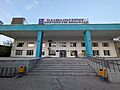
Ulaanbaatar is home to most of Mongolia's major universities. These include the National University of Mongolia. Other important universities are the Mongolian University of Science and Technology and the Mongolian National University of Medical Sciences.
The American School of Ulaanbaatar and the International School of Ulaanbaatar offer Western-style education. They teach in English for both Mongolian and foreign students.
Libraries for Everyone


The National Library of Mongolia is in Ulaanbaatar. It has a large collection of historical items. It also has books in many languages and a special collection for children.
The Metropolitan Central Library of Ulaanbaatar is a public library. It has about 500,000 items. It serves many users each year and lends out hundreds of thousands of books. It charges a small fee for registration. The library also offers free internet access.
In 1986, Ulaanbaatar created a system for all public libraries. This is called the Metropolitan Library System of Ulaanbaatar (MLSU). It helps manage and support all public libraries in the capital. It also helps school and children's libraries. Besides the main library, there are four branch libraries. There is also a Children's Central Library.
University Libraries
- Library of Mongolian State University of Education
- Library of the Academy of Management
- Library of the National University of Mongolia
- Libraries of the Academy of Sciences (3 department libraries)
- Library of the Institute of Language and Literature
- Library of the Institute of History
- Library of the Institute of Finance and Economics
- Library of the Agriculture University
Digital and Special Libraries
The Press Institute in Ulaanbaatar manages a Digital Archive of Mongolian Newspapers. This collection focuses on newspapers after the fall of communism.
The American Center for Mongolian Studies (ACMS) has a research library. It has books about Mongolia in many languages. It also has an online library with digital resources.
There is a Speaking Library at School #116 for visually impaired students. The Mongolia-Japan Center for Human Resources Development also has a library. It helps Mongolians studying Japanese and has books about Mongolia in Japanese.
Sports and Fun in Ulaanbaatar
_01.jpg)
The National Sports Stadium is the main sports place. It hosts the yearly Naadam festival. Other places include the Buyant Ukhaa Sport Palace for many sports. The AIC Steppe Arena is for indoor skating. Bökhiin Örgöö is for Mongolian wrestling. Sky Resort is a popular place for skiing. It also has a golf course.
Ulaanbaatar has hosted international sports events. These include the 2019 FIBA 3x3 Under-18 World Cup. It also hosted the 2023 East Asian Youth Games.
Ulaanbaatar City FC is a professional football club in the city. It plays in the top Mongolian football league.
City Life and Services
Getting Around Ulaanbaatar
.jpg)
Ulaanbaatar is the main center for roads, air travel, and trains in Mongolia. People get around the city using private cars, public buses, trolleybuses, and taxis. There are also unofficial taxis and minivans. In 2021, over 662,000 vehicles were registered in the city.
Public Transportation
Buses are the main way to get around Ulaanbaatar. In 2021, 950 buses served 105 routes. About 480,000 to 500,000 people use buses every day. The bus fleet includes different sizes of buses and trolleybuses.
In 2015, a smart card system called U Money was started for bus payments. Before that, people paid cash to conductors. As of 2021, fares are 100-200₮ for children and 300-500₮ for adults.
There are also official taxis in the city. However, many people use unofficial taxis or ride-sharing apps like UBCab.
Roads and Traffic
As of 2024, Ulaanbaatar had 1253 km (778 miles) of paved roads. However, the ger districts often have fewer paved roads. About 720,000 vehicles were registered in the city in 2023.
Traffic is very heavy on the main roads. These include Peace Avenue and Chinggis Avenue. Traffic jams are a big problem in Ulaanbaatar. In 2021, cars moved at an average speed of only 8.9 km/h (5.5 mph) during rush hour. People spent about 2.5 hours a day stuck in traffic. Another problem is flooding, as only a small part of the paved roads have a proper drainage system.
Train Travel

The Trans-Mongolian Railway runs through the city center. The main train station is Ulaanbaatar railway station.
Air Travel
Ulaanbaatar is served by Chinggis Khaan International Airport. It is located 52 km (32 miles) south of the city. This airport is Mongolia's main air travel hub. It replaced the old airport in 2021. It has flights to Europe, Asia, and other cities in Mongolia. You can get to the airport from Ulaanbaatar by taxi or shuttle.
The city also has 6 helipads for helicopters.
Future Plans for Transport
To help with traffic, new ideas are being considered. These include a proposed subway system. In April 2024, construction began on a cable car system.
Energy and Heating
.jpg)
Ulaanbaatar gets most of its electricity from power plants that burn coal. The largest is Thermal Power Plant No. 4. These plants also provide hot water and heat buildings during the cold winter months. However, the ger districts around the city are not connected to this central heating system. People in these areas have to burn coal and other materials to stay warm.
In 2019, the government banned burning raw coal in Ulaanbaatar. Instead, they gave out special coal briquettes. They said these were more efficient and caused less smoke. However, smoke is still a big problem in winter.
Water Supply
Ulaanbaatar gets all its water from underground sources. This water is refilled by the Tuul River. The Water Supply and Sewage Authority manages the city's water.
Air Pollution in Ulaanbaatar

Air pollution is a very serious problem in Ulaanbaatar, especially in winter. The amount of tiny particles in the air is often much higher than what the World Health Organization (WHO) recommends. These levels are even higher than in some industrial cities in northern China. In winter, smoke often makes it hard to see. It has even caused problems for flights at the airport.
The main causes of pollution are the simple stoves used for heating and cooking in the ger districts. Coal-fueled power plants also add to the problem. Ulaanbaatar's location in a valley also makes it worse. The mountains block the winter winds, so the polluted air gets trapped in the city.
Ulaanbaatar's Sister Cities
Ulaanbaatar has "sister city" relationships with many cities around the world. These partnerships help with cultural exchange and cooperation.
 Moscow, Russia (1957)
 Hohhot, China (1991)
 Seoul, South Korea (1995)
- Irkutsk, Russia (1998)
 Denver, USA (2001)
 Havana, Cuba (2002)
 Ankara, Turkey (2003)
- Oakland, USA (2006)
- Elista, Russia (2010)
- Gaziantep, Turkey (2010)
- Beijing, China (2014)
- Novosibirsk, Russia (2015)
- Ulan-Ude, Russia (2015)
- Incheon, South Korea (2017)
 Bangkok, Thailand (2017)
 Astana, Kazakhstan (2019)
- Chongqing, China (2022)
 Bishkek, Kyrgyzstan (2023)
Images for kids
-
Roof tiles recovered from Wang Khan's 12th-century palace in Ulaanbaatar
-
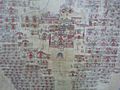
Detail of 19th-century painting of Urga (Ulaanbaatar): in the center the movable square temple of Bat Tsagaan, built in 1654, besides numerous other temples
-
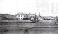
The Russian Consulate of Urga (Ulaanbaatar) and the Holy Trinity Church, both built in 1863
-
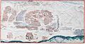
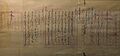
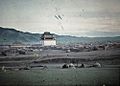
A 1913 panorama of the city. The large circular compound in the middle is the Zuun Khuree temple-palace complex. The Gandan temple complex is to the left. The palaces of the Bogd are to the south of the river. To the far bottom right of the painting is the Maimaicheng district. To its left are the white buildings of the Russian consulate area. Manjusri Monastery can be seen on Mount Bogd Khan Uul at the bottom-right of the painting.
-
Jarlig proclaiming Ikh Khüree as Niislel (Capital) Khüree, 1912.
-
Green areas were increased in the city center during the communist era
-
Outdoor market near Gandan Hill in 1972; State Department Store in the background
-
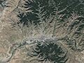
Satellite image of Ulaanbaatar, showing the city core along the Tuul River Valley with Bogd Khan Mountain dominating the south. The city's ger districts sprawl into the mountainous areas in the north.
-
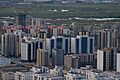
New high rise constructions in Yaarmag area
-
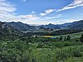
Gorkhi-Terelj National Park is a popular picnic and camping ground all year round
-
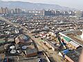
Ger districts against a backdrop of high-rise new buildings in Ulaanbaatar
-
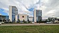
Newly built city government headquarters in Yaarmag area, Khan Uul
-
Mongolian National Song and Dance Academic Ensemble
-
1913 color photo of Gandan Monastery
-
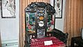
Throne given to Zanabazar by his disciple the Kangxi Emperor, used by later Jebtsundamba Khutuktus in Urga
-
Zanabazar's Fine Arts Museum, built in 1905 by Russian merchant Gudvintsal as a trading shop
-

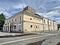
Ulaanbaatar History Museum, built in 1904 by a Buryat-Mongol merchant
-
Choijin Lama Temple complex, built in 1904–1908
-
West Geser Temple, built in 1919–1920 by Guve Ovogt Zakhar
-
Residence of Prince Chin Wang Khanddorj (Minister of Foreign Affairs), built in 1913
-
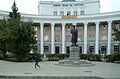
Main building of the National University of Mongolia
-
National Library of Mongolia
-
Ulaanbaatar Public Library in 2023
-
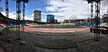
National Sports Stadium in 2019
-
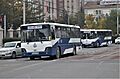
Bus in Ulaanbaatar
-
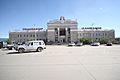
Ulaanbaatar railway station
-
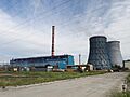
Thermal Power Plant No. 4
-
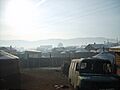
Ger district in Ulaanbaatar with the Temple of Boddhisattva Avalokiteshvara at Gandantegchinlen Monastery in the background

See also
 In Spanish: Ulán Bator para niños
