Edgemont, South Dakota facts for kids
Quick facts for kids
Edgemont
|
|
|---|---|
| Edgemont, South Dakota | |

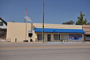
Edgemont City Hall, August 2017
|
|
| Motto(s):
"To The Black Hills"
|
|

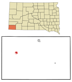
Location in Fall River County and the state of South Dakota
|
|
| Country | United States |
| State | South Dakota |
| County | Fall River |
| Incorporated | 1895 |
| Area | |
| • Total | 1.38 sq mi (3.58 km2) |
| • Land | 1.38 sq mi (3.58 km2) |
| • Water | 0.00 sq mi (0.00 km2) |
| Elevation | 3,517 ft (1,072 m) |
| Population
(2020)
|
|
| • Total | 725 |
| • Density | 524.60/sq mi (202.51/km2) |
| Time zone | UTC-7 (Mountain (MST)) |
| • Summer (DST) | UTC-6 (MDT) |
| ZIP code |
57735
|
| Area code(s) | 605 |
| FIPS code | 46-18300 |
| GNIS feature ID | 1267376 |
| Website | City of Edgemont |
Edgemont is a small city located in Fall River County, South Dakota, in the United States. In 2020, about 725 people lived there. The city is found on the southern edge of the famous Black Hills area in southwestern South Dakota.
Edgemont is an important stop for BNSF freight trains. Train crews often change here on their long journeys. In early 2023, nearly 50 different train crews were working out of Edgemont.
Contents
History of Edgemont
Edgemont began in 1890. This was when the Burlington Railroad built its tracks through the area. The railroad helped the town grow.
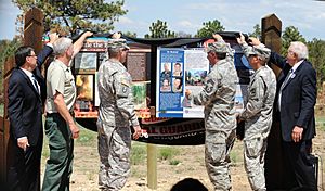
In 2012, a large wildfire called the White Draw Fire burned near Edgemont. It was about eight miles northeast of the city. Sadly, an airplane helping to fight the fire crashed, and some people were hurt.
Geography and Location
Edgemont covers an area of about 1.38 square miles (3.58 square kilometers). All of this area is land.
The city is located where US Highway 18 and South Dakota Highway 471 meet. Its closest towns are Burdock and Dewey to the northwest. Hot Springs is to the northeast. To the south, you can find Provo and Rumford.
Edgemont is just south of the Elk Mountains. This is a small mountain range that is part of the larger Black Hills.
Edgemont's Climate
Edgemont has a cold semi-arid climate. This means it's usually dry and can have very hot summers and cold winters. The hottest temperature ever recorded in Edgemont was 111°F (44°C). This happened twice, in June and July of 2016. The coldest temperature was -40°F (-40°C) in December 1989.
| Climate data for Edgemont, South Dakota (1991–2020 normals, extremes 1979–present) | |||||||||||||
|---|---|---|---|---|---|---|---|---|---|---|---|---|---|
| Month | Jan | Feb | Mar | Apr | May | Jun | Jul | Aug | Sep | Oct | Nov | Dec | Year |
| Record high °F (°C) | 68 (20) |
74 (23) |
86 (30) |
92 (33) |
96 (36) |
111 (44) |
111 (44) |
107 (42) |
105 (41) |
95 (35) |
80 (27) |
70 (21) |
111 (44) |
| Mean maximum °F (°C) | 54.1 (12.3) |
59.1 (15.1) |
74.4 (23.6) |
82.3 (27.9) |
90.1 (32.3) |
97.9 (36.6) |
102.4 (39.1) |
100.5 (38.1) |
96.9 (36.1) |
85.4 (29.7) |
69.8 (21.0) |
56.0 (13.3) |
103.5 (39.7) |
| Mean daily maximum °F (°C) | 33.6 (0.9) |
38.4 (3.6) |
50.3 (10.2) |
59.3 (15.2) |
68.7 (20.4) |
80.1 (26.7) |
88.8 (31.6) |
87.3 (30.7) |
77.6 (25.3) |
61.8 (16.6) |
46.9 (8.3) |
34.8 (1.6) |
60.6 (15.9) |
| Daily mean °F (°C) | 18.9 (−7.3) |
23.1 (−4.9) |
34.2 (1.2) |
43.4 (6.3) |
53.3 (11.8) |
64.0 (17.8) |
71.8 (22.1) |
69.7 (20.9) |
59.5 (15.3) |
44.5 (6.9) |
30.8 (−0.7) |
20.1 (−6.6) |
44.4 (6.9) |
| Mean daily minimum °F (°C) | 4.3 (−15.4) |
7.8 (−13.4) |
18.0 (−7.8) |
27.4 (−2.6) |
37.9 (3.3) |
47.9 (8.8) |
54.8 (12.7) |
52.1 (11.2) |
41.5 (5.3) |
27.3 (−2.6) |
14.8 (−9.6) |
5.4 (−14.8) |
28.3 (−2.1) |
| Mean minimum °F (°C) | −14.9 (−26.1) |
−10.6 (−23.7) |
2.1 (−16.6) |
15.3 (−9.3) |
26.1 (−3.3) |
39.1 (3.9) |
48.2 (9.0) |
44.2 (6.8) |
30.2 (−1.0) |
13.2 (−10.4) |
−2.5 (−19.2) |
−11.3 (−24.1) |
−22.9 (−30.5) |
| Record low °F (°C) | −37 (−38) |
−39 (−39) |
−25 (−32) |
−9 (−23) |
18 (−8) |
28 (−2) |
40 (4) |
32 (0) |
8 (−13) |
−16 (−27) |
−21 (−29) |
−40 (−40) |
−40 (−40) |
| Average precipitation inches (mm) | 0.37 (9.4) |
0.48 (12) |
0.95 (24) |
1.84 (47) |
2.65 (67) |
2.64 (67) |
2.21 (56) |
1.50 (38) |
1.21 (31) |
1.26 (32) |
0.56 (14) |
0.44 (11) |
16.11 (409) |
| Average snowfall inches (cm) | 5.0 (13) |
5.6 (14) |
6.4 (16) |
4.6 (12) |
1.0 (2.5) |
0.0 (0.0) |
0.0 (0.0) |
0.0 (0.0) |
0.1 (0.25) |
2.7 (6.9) |
4.7 (12) |
6.1 (15) |
36.2 (92) |
| Average precipitation days (≥ 0.01 in) | 4.5 | 5.0 | 6.1 | 8.9 | 11.4 | 10.3 | 7.9 | 7.4 | 6.0 | 6.7 | 4.5 | 4.0 | 82.7 |
| Average snowy days (≥ 0.1 in) | 3.4 | 4.0 | 3.1 | 2.2 | 0.3 | 0.0 | 0.0 | 0.0 | 0.1 | 1.0 | 2.7 | 3.4 | 20.2 |
| Source: NOAA | |||||||||||||
Education in Edgemont
Students in Edgemont attend schools that are part of the Edgemont School District. The district has two main schools:
- One elementary school for younger students.
- One high school, known as Edgemont High School, for older students.
Population and People
| Historical population | |||
|---|---|---|---|
| Census | Pop. | %± | |
| 1900 | 479 | — | |
| 1910 | 816 | 70.4% | |
| 1920 | 1,254 | 53.7% | |
| 1930 | 1,103 | −12.0% | |
| 1940 | 1,002 | −9.2% | |
| 1950 | 1,158 | 15.6% | |
| 1960 | 1,772 | 53.0% | |
| 1970 | 1,174 | −33.7% | |
| 1980 | 1,468 | 25.0% | |
| 1990 | 906 | −38.3% | |
| 2000 | 867 | −4.3% | |
| 2010 | 774 | −10.7% | |
| 2020 | 725 | −6.3% | |
| U.S. Decennial Census | |||
The population of Edgemont has changed over the years. In 2010, there were 774 people living in the city. The city had 386 households. About 41.5% of these were married couples.
The average age of people in Edgemont in 2010 was 51.3 years.
- About 17.8% of residents were under 18 years old.
- About 24.7% were 65 years or older.
The city had slightly more males (51.3%) than females (48.7%).
See also
 In Spanish: Edgemont (Dakota del Sur) para niños
 | George Robert Carruthers |
 | Patricia Bath |
 | Jan Ernst Matzeliger |
 | Alexander Miles |


