Oregon Caves National Monument and Preserve facts for kids
Quick facts for kids Oregon Caves National Monument and Preserve |
|
|---|---|
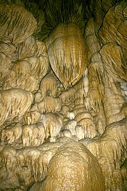
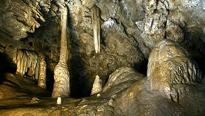
Formations resembling drapery in a dome-shaped pit in Oregon Caves
|
|
| Location | Cave Junction, Josephine, Oregon, United States |
| Area | 4,554 acres (18.43 km2) |
| Elevation | 4,377 ft (1,334 m) |
| Established | July 12, 1909 |
| Visitors | 80,613 in 2016 |
| Governing body | National Park Service |
| Website | Oregon Caves National Monument and Preserve |
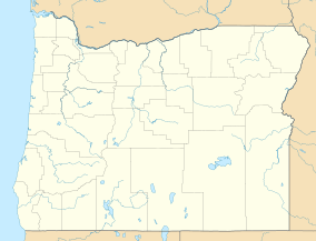
The Oregon Caves National Monument and Preserve is a special protected area in southwestern Oregon, United States. It's located in the northern Siskiyou Mountains. This park covers about 4,554 acres (1,843 hectares). It includes a beautiful marble cave. The park is managed by the National Park Service (NPS). It's found in Josephine County, close to the Oregon–California border.
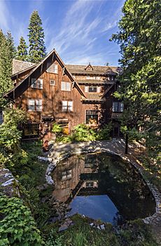
A local person named Elijah Davidson found the cave in 1874. For many years, people tried to create tourist businesses there, but it was hard to get to. In 1909, President William Howard Taft made it a National Monument. This protected the cave and the land around it. Later, better roads and more cars helped more people visit. A famous building called the Oregon Caves Chateau, a six-story hotel, was built in 1934. It's now a National Historic Landmark. The NPS took over managing the monument in 1933. They offer tours of the cave for visitors. In 2014, the park grew much larger. It was renamed the National Monument and Preserve. A stream inside the cave was also named the River Styx. It became part of the National Wild and Scenic Rivers System.
Oregon Caves is a unique type of cave. It formed in marble rock. The passages inside stretch for about 15,000 feet (4,572 meters). The original rock was limestone. It changed into marble over millions of years. This happened during the formation of the Klamath Mountains. The cave itself is only a few million years old. Besides being a popular tourist spot, the cave is important for science. Some parts of the cave, not open to tours, hold important fossils. Visitors to the park can explore the cave, hike, take photos, and watch for wildlife. One trail leads to the "Big Tree." It's the widest Douglas fir tree known in Oregon. You can find places to stay and eat at The Chateau or in nearby Cave Junction. Camping is also available in the preserve.
Contents
Exploring Oregon Caves
Oregon Caves National Monument and Preserve is located in the Siskiyou Mountains. These mountains are part of the Klamath Mountains range. The main part of the park is about 6 miles (10 km) north of the Oregon–California border. It's in Josephine County, Oregon. There's also a visitor center in Cave Junction. This city is about 40 miles (64 km) east of the Pacific Ocean. The highest points in the monument are around 5,480 feet (1,670 meters) above sea level.
In 2014, the U.S. Congress made the protected area bigger. They also changed its name to Oregon Caves National Monument and Preserve. This means there are now two connected parts. The "preserve" covers about 4,070 acres (1,647 hectares). Both the monument and the preserve are managed by the same team.
To reach Oregon Caves by road, it's about 55 miles (89 km) southwest of Grants Pass. It's also about 300 miles (483 km) south of Portland. From San Francisco, it's about 450 miles (724 km) north. The caves are 20 miles (32 km) east of Cave Junction. You get there by taking Oregon Route 46.
Even though it's called "Oregon Caves" (plural), the main cave is one big system. Its known passages are about 15,000 feet (4,572 meters) long. Eight other smaller caves have also been found in the park.
Water from the monument's forests forms small streams. These streams flow into the Illinois River. One stream, Upper Cave Creek, flows on the surface. Then it disappears underground into the cave. More water enters the cave from above. The stream then comes out of the main entrance as Cave Creek. Inside the cave, this stream is called the River Styx. In 2014, the River Styx was added to the National Wild and Scenic Rivers System. It's the only underground river in this special system.
A Look Back in Time
Scientists believe the first people in the Rogue River area were hunters and gatherers. They arrived in southwestern Oregon at least 8,500 years ago. They built permanent villages along streams about 1,500 years before Europeans arrived. However, there's no sign that native groups, like the Takelma people, ever used the cave.
The area was very remote. Early explorers and fur traders mostly passed it by. But in 1851, gold was found near Jacksonville. This brought many new people to the region. Josephine County was created in 1854. It was named after the daughter of a gold miner. Even with the gold rush, the county's population was still small in 1870.
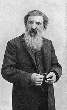
Elijah Jones Davidson discovered the cave in 1874. He had moved to Oregon with his family. They settled near Williams Creek, about 12 miles (19 km) from the cave.
Only a few people visited the cave in the next ten years. One visitor was Thomas Condon, a geology professor from the University of Oregon. In 1884, he and his students explored the cave by candlelight. After this, Walter Burch tried to start a cave business. He called it "Limestone Caves." Visitors paid $1 for a guided tour, a camping spot, and "medicinal" cave water. But the trip was too hard for most tourists. The business closed in 1888.
In the early 1890s, another company tried to make the cave a big tourist spot. Its leader, Alfonso B. Smith, made wild claims about the cave. He said it was 22 miles (35 km) long and had 600 rooms. He even claimed a horse and buggy could drive through 10 miles (16 km) of it! Smith's efforts led to a lot of damage inside the cave. Passages were widened, and formations were broken. After spending all the company's money, Smith disappeared in 1894. The business failed.
The cave and surrounding land belonged to the public. In the 1890s, the government started protecting these lands. In 1903, President Theodore Roosevelt set aside millions of acres of forest. This included the area around the cave, which became part of Siskiyou National Forest. The United States Forest Service was created in 1905 to manage these lands. In 1908, Congress passed the Antiquities Act. This law allowed the President to create National Monuments. In 1909, President William Howard Taft made Oregon Caves a National Monument. The Forest Service managed it.
The monument was hard to reach. In 1920, only 1,800 people visited. But things changed when more Americans started traveling by car. New roads were built, including the Oregon Caves Highway. Groups like the "Cavemen" from Grants Pass helped promote the monument. They dressed in animal skins and staged events. By 1928, about 24,000 people visited the cave each year.
More visitors meant a need for places to stay. In 1923, the Forest Service hired the Oregon Caves Company. This company ran cave tours and improved lodging. They built The Chalet, with a dining room and gift shop. Later, they added cabins for tourists. In 1928, Congress approved money for electric lights in the cave. They also funded a system to wash formations. An artificial exit tunnel was built to make tours easier. This 500-foot (152-meter) tunnel was finished in 1931.
In 1933, the National Park Service took over managing the monument. The six-story Oregon Caves Chateau hotel was finished in 1934. Gust Lium designed the Chateau in a rustic style. Its furniture was made in a special "Monterey" style. During the 1930s, the Civilian Conservation Corps (CCC) helped improve the park. They installed water lines, improved trails, and worked on landscaping.
The Chateau was damaged by a flood in 1964 but was repaired. By 1968, one million people had visited the cave. In 1987, the Chateau became a National Historic Landmark. In 1992, 60 acres (24 hectares) of the monument, including the Chateau, became the Oregon Caves Historic District. In 2001, the Park Service started running the cave tours themselves.
In 2014, the protected area grew much larger. It expanded by about 4,070 acres (1,647 hectares). This new area became the "preserve." It includes forests, meadows, and mountains. Hunting is allowed in the preserve, but not in the monument. This expansion helps protect the area's natural beauty.
How the Cave Formed
Most caves form when water dissolves rocks like limestone. But Oregon Caves formed in marble. Only a few caves managed by the NPS are marble caves.
The rock that formed the cave started as limestone about 190 million years ago. It was part of a tectonic plate under the Pacific Ocean. As this plate moved under the North American plate, the limestone was squeezed and heated. This process changed it into marble. Later, more movements lifted the marble to about 4,000 feet (1,219 meters) above sea level.
The cave itself formed much later. Water slowly seeped into cracks in the marble. Over time, it dissolved enough rock to create tunnels. Scientists study formations inside caves to guess their age. Oregon Caves is thought to be at least one million years old. It's probably not much older than a few million years.
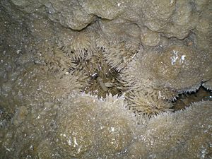
Marble is made of calcite, just like limestone. Caves often form when slightly acidic groundwater dissolves calcite. The opposite process can create beautiful cave formations. These are called speleothems. They include stalactites, which hang from the ceiling like icicles. And stalagmites, which grow up from the floor. These form when water with dissolved calcite drips slowly. As the water loses its acidity, it leaves behind calcite. Oregon Caves has many different calcite formations. Some in the public areas have been damaged over time. But the narrow, twisting passages are mostly preserved.
The cave isn't just marble. Streams have brought in dirt and gravel from the surface. There are also other types of rock inside the cave. These include diorite, shale, and sandstone.
Ancient Life in the Cave
The monument has over 50 places where fossils have been found. These fossils range from the Late Pleistocene to the Holocene periods. Scientists have found a grizzly bear fossil over 50,000 years old. A jaguar fossil, between 20,000 and 40,000 years old, was also discovered. Other fossils include amphibians, and rare finds of the mountain beaver and the blue grouse. The mammal fossils found in the cave are very important for understanding ancient life.
Weather in the Park
The main part of the monument is in the mountains. Elevations range from about 3,680 to 5,480 feet (1,122 to 1,670 meters). Because it's close to the ocean, the climate is fairly mild. In winter, temperatures are usually between 20 and 40 degrees Fahrenheit (–7 and 4 degrees Celsius). In summer, they range from 50 to 90 degrees Fahrenheit (10 to 32 degrees Celsius). But inside the cave, the temperature is always about 44 degrees Fahrenheit (7 degrees Celsius). The park gets about 55 inches (1,400 mm) of rain each year. Most of this falls as wet snow.
Cave Junction, which is lower at 1,800 feet (549 meters), is warmer and wetter. In December and January, highs average about 50 degrees Fahrenheit (10 degrees Celsius). Lows average about 33 degrees Fahrenheit (1 degree Celsius). July and August are the warmest months. Highs average 94 degrees Fahrenheit (34 degrees Celsius). Lows average about 50 degrees Fahrenheit (10 degrees Celsius).
Plants and Animals
The Klamath–Siskiyou region is known for having many different kinds of plants and animals. The monument has 391 types of vascular plants. It also has many kinds of mosses, lichens, and mushrooms. Trees in the park include Douglas fir, oak, white fir, and alder. One of the oldest trees is the "Big Tree." It's thought to be the widest Douglas fir in Oregon. Its base is about 41 feet (12 meters) around. It's estimated to be 600 to 800 years old. No plants in the monument have special conservation status.
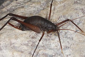
The park is home to about 50 types of mammals and 86 types of birds. There are also 11 types of reptiles and amphibians. You can find 8 types of bats and over 200 types of arthropods. Other creatures include snails, slugs, butterflies, and moths. About 160 of these species live inside the cave. Outside the cave, you might see black-tailed deer, Steller's jay, common raven, and Townsend's chipmunk. Less common animals include black bear, cougar, and Pacific giant salamander.
Some animal species in the park are considered "at-risk." These include the northern spotted owl and the California mountain kingsnake. Five types of bats that live in the cave are also at risk. These are the Townsend's big-eared bat, long-eared myotis, fringed myotis, long-legged myotis, and Yuma myotis.
Things to Do and Places to Stay
Oregon Caves National Monument and Preserve is open all year. However, snow can sometimes block the road to the park. Cave tours are usually offered from mid-April to early November. The schedule depends on the weather in spring and fall. The Illinois Valley Visitor Center in Cave Junction also has information about the cave.
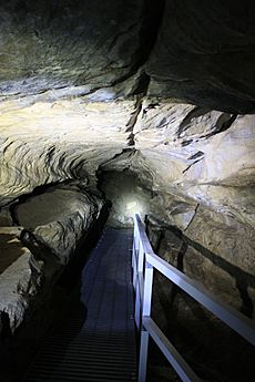
You can buy cave tour tickets online. A few tickets might be available first-come, first-served. The main "discovery cave tour" with a ranger lasts 90 minutes. It involves climbing over 500 steep stairs. Some passages are as low as 45 inches (114 cm) from floor to ceiling. This tour is not recommended for people with heart, lung, or walking problems. Children under 42 inches (107 cm) tall cannot go on the full cave tour. The NPS also offers special "introduction to caving" tours by reservation. These go off the main trails.
The cave is always about 44 degrees Fahrenheit (7 degrees Celsius). So, the NPS suggests wearing warm clothes for tours. Good walking shoes are also needed because surfaces can be slippery. You can't bring flashlights, big bags, tripods, or pets on tours. To protect bats from a disease called white nose syndrome, don't bring clothes or gear into Oregon Caves that have been in any other cave or mine.
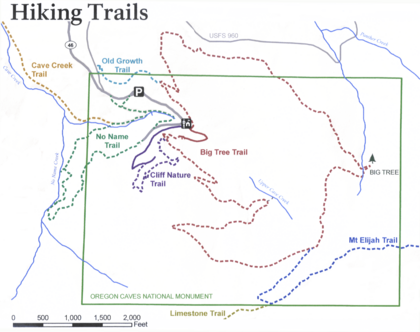
You can stay at The Chateau inside the monument. It has 23 rooms for rent. Several hiking trails wind through the monument and nearby forests. The Big Tree Trail is 3.3 miles (5.3 km) long. It climbs 1,100 feet (335 meters) from the visitor center to the Big Tree. The No Name Trail is 1.3 miles (2.1 km) long. It follows Cave Creek and climbs steeply. Two short trails lead to waterfalls. The Cliff Nature Trail is about 1 mile (1.6 km) long. It passes over marble rocks and through fir forests. The Old Growth Trail is 0.8 miles (1.3 km) long. It connects the Chateau to the main parking lot. Other trails include Cave Creek, Mt. Elijah, and Limestone.
There are also hotels, bed and breakfasts, and motels nearby. While camping isn't allowed in the monument, the NPS has the Cave Creek Campground in the preserve. The USFS also has a campground nearby. Private campgrounds are in the area too. The Chateau has a restaurant, coffee shop, and deli. Cave Junction has several restaurants. The monument grounds also have picnic tables.
See also
 In Spanish: Monumento nacional Cuevas de Oregón para niños
 | Stephanie Wilson |
 | Charles Bolden |
 | Ronald McNair |
 | Frederick D. Gregory |


