Alston, Cumbria facts for kids
Quick facts for kids Alston |
|
|---|---|
| Town | |
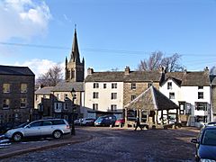 Alston town centre |
|
| Population | 1,128 |
| OS grid reference | NY716462 |
| Civil parish |
|
| Unitary authority |
|
| Ceremonial county |
|
| Region | |
| Country | England |
| Sovereign state | United Kingdom |
| Post town | ALSTON |
| Postcode district | CA9 |
| Dialling code | 01434 |
| Ambulance | North West |
| EU Parliament | North West England |
| UK Parliament |
|
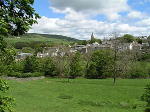
Alston is a small town in Westmorland and Furness, Cumbria, England. It is part of the Alston Moor area. Alston is about 1,000 feet (300 m) above sea level in the North Pennines. It shares the title of 'highest market town in England' with Buxton, Derbyshire.
Even though it's a bit isolated, Alston has good roads. These roads connect it to the Tyne Gap in the north. They also link to Weardale and Teesdale in the south-east. You can also get to Penrith in the south-west. Many buildings in the town centre are protected as conservation areas. Alston used to be a big mining town. People found lead, zinc, iron, copper, and coal nearby.
Contents
Alston's Location and Landscape
Alston is in the North Pennines Area of Outstanding Natural Beauty. This means it's a special place with beautiful scenery. It's more than 16.3 miles (26.2 km) from the closest town, Haltwhistle. The town is surrounded by open moorland. Nearby villages include Garrigill and Nenthead.
Alston is about 44.5 miles (71.6 km) west of Newcastle upon Tyne. It's also 30.1 miles (48.4 km) south-east of Carlisle. Penrith is 19.7 miles (31.7 km) north-east. Hexham is 21.6 miles (34.8 km) south-west.
The town sits where the A686, A689, and B6277 roads meet. It's also where the River South Tyne and River Nent join. On May 18, 2013, heavy rain caused floods in Alston. Thirty-six properties were affected. The area's landscape is made of limestone, sandstone, and shale. It has many minerals, especially lead. Mining has greatly changed the landscape over time.
A Look Back at Alston's History
Early People and Roman Times
The oldest signs of people living here are from pottery and tools. These were found in ancient burial mounds near Alston. They are from about 2000 to 1700 BC.
The Romans were also in the area. They built a fort called Whitley Castle. It was likely called Epiacum. Roman soldiers built and rebuilt it between the 2nd and 3rd centuries. This fort was on the Maiden Way Roman road. This road went north from Kirkby Thore to Carvoran on Hadrian's Wall. Whitley Castle helped protect this important supply route. It also guarded lead and silver mines.
The name Alston comes from "Aldeneby" (1164–71) and "Aldeneston" (1209). It likely means "the settlement or farm belonging to Halfdan," a Viking man.
Who Ruled Alston?
In the 900s, Alston Moor was part of Tynedale. This area belonged to the Scottish Kings but was inside England. This caused a lot of confusion about who was in charge.
In 1085, the Barons de Veteriponte became the first known Lords of the Manor. They held the moor for the kings of Scotland. But the kings of England kept the rights to the minerals. In 1279, it was decided that miners paid taxes to the English crown. This meant miners lived in their own communities. They were protected by England.
In 1296, John de Balliol, the king of Scotland, attacked northern England. So, Edward I took back the Scottish lands. Tynedale, including Alston Moor, came under English control. It has stayed that way ever since.
Even though Alston is on the River Tyne, it has always been part of Cumberland. Later, it became part of Cumbria. This was probably because the mines were managed from Carlisle.
Alston's Mining Past
Historically, people mined lead, zinc, iron, copper, and coal here. The Roman fort of Whitley Castle might have been built to control these lead mines.
In the 1200s, the area was known for its silver mines. Silver was found in lead (up to 40 troy ounces per long ton of smelted lead). This silver was used to make coins in Carlisle. Most mining was small until the mid-1700s. By 1768, there were 119 lead mines in Alston parish.
The London Lead Company was the biggest mine owner. This Religious Society of Friends (Quakers) group had good policies for its workers. In 1745, they built a school, library, and other facilities in Nenthead, 5 miles (8 km) away. Many of the last mines closed in the 1950s. A small coal mine (Ayle Colliery) still works today.
How Alston is Governed
Alston is in the Penrith and Solway area for the UK Parliament. Markus Campbell-Savours became its MP in 2024.
For local government, Alston is part of the Westmorland and Furness authority. Before April 1, 2023, it was in the Eden District Council. Alston does not have its own town council. Instead, it is part of the Alston Moor Parish Council.
Alston's Modern Economy
The area is no longer actively mined for precious metals. But its mining history helps with tourism. There are not many jobs right in Alston. This is why the population has dropped from 6,858 in 1841 to 1,128 today.
Farming in the Moorlands
The land around Alston is mostly used for sheep farming. Many farmers also offer bed and breakfast stays. Farming can be very hard in winter due to the severe weather.
Tourism is Important
Tourism is now a key part of Alston's economy. A big attraction is the South Tynedale Railway. This is a narrow-gauge railway and heritage centre. Alston is part of the North Pennines Area of Outstanding Natural Beauty. It's also a European Geopark.
Alston is famous for its cobbled streets and old stone buildings. The area's mining past is used to attract visitors. Nenthead Mines, near Nenthead, is a Scheduled Monument. Volunteers manage it. The Nenthead Mines Conservation Society has open days. Visitors can learn about lead mining and take an underground tour. The Pennine Way, a famous walking path, goes near Alston. The Sea to Sea Cycle Route (C2C) also passes through the town.
Shops and Services
Alston has various shops. These include a whole foods shop and a Co-op supermarket. There's also a Spar, a hardware shop, and a post office. You can find outdoor clothing, an organic bakery, and gift shops.
The town has four pubs, several cafés, and a take-away. There are two hotels and many B&Bs. You'll also find two petrol stations, a gym, and a hairdressers. The last bank, Barclays, closed in 2015.
Steam trains on the South Tynedale Railway run from April to October. They offer a short trip through nice scenery.
Metal Working Today
From 1940 to 1980, a foundry employed about 200 people. When it closed, unemployment in the area jumped.
Today, Bonds Precision Castings Limited is a main employer. They took over Precision Products in 2008. This company makes stainless steel and special alloy castings.
Population Changes
In 1831, the population of Alston Moor was 6,858 people. Today, it's about 1,200. The town of Alston had 1,128 people in 2001. The community has its own website, Cybermoor Project. This project brought the Internet to many homes in Alston Moor. It helped people access online courses and training.
Famous People from Alston
- Nicholas Ridley, a politician and government minister.
Important Buildings and Landmarks
Alston Town Hall
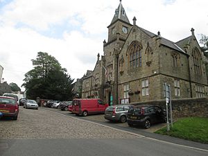
Alston Town Hall is a central place for the community. Many local events happen here. It also has the tourist information centre and the public library. The building was finished in 1858. It was built in the Gothic Revival style.
Alston High Mill
High Mill was built in 1767. It was a water-powered corn mill. The famous engineer John Smeaton designed it. Smeaton is also known for the Eddystone Lighthouse.
High Mill is a Grade II listed building. This means it's historically important. It has been changed over time, but Smeaton's design is still clear. Inside, only the water wheel and pit wheel remain from the original mill.
In July 2023, a private owner bought High Mill. Work is now underway to fix it up. It will be used as an arts and crafts workshop. Part of the mill might become a small museum. It will show the wheel and old tools.
Market Cross
Alston does not have a regular market anymore. But it still has the legal right to hold one. The market cross is a central point in town. The current cross was built in 1981. It replaced an earlier one that was knocked down by a wagon. That one had replaced a cross from 1883.
A regular producers' market now happens in the town hall. It runs from April to September. It sells food and crafts from Cumbria, Northumberland, and County Durham.
St Augustine of Canterbury Church
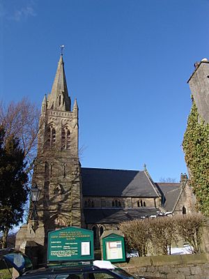
The parish church was built in 1869. It stands where two older churches used to be. Even though it's in Cumbria, the church is part of the Diocese of Newcastle. The church spire was finished in 1886.
A special item in the church is a clock. It belonged to James Radclyffe, 3rd Earl of Derwentwater. He was executed for treason. The clock is thought to be from the 1500s. It was fixed in 1978. One of the church bells, cast in 1714, also belonged to the Earl. Four bells were added in memory of Andrew Graham Stavert Steele. The bells cannot be rung because the tower is not strong enough. Instead, they are struck by a clapper.
Clarghyll Hall
Clarghyll Hall is north of Alston. It's a Grade II* listed fortified manor house. It dates back to the 1500s. It was once home to the Whitfield family. From 1847 to 1889, Rev. Octavius James lived there. He added a chapel and study. This new part burned down in 1889, and Rev James died in the fire.
Nent Force Level
In 1776, John Smeaton started building an underground drain. It was called the "Nent Force Level". Its purpose was to remove water from the mines in the Nent Valley. It also helped transport mined materials and find new minerals. This underground canal took 66 years to build. It cost £80,000. People sometimes called it "Smeaton's Folly."
In the 1830s, a mine manager said you could visit it by boat. The boats were 30 feet long. They moved in four feet of water. This allowed people to sail a few miles underground. It was meant to be 9 feet square. But in softer ground, it was made bigger. The amount of ore found was not as much as hoped, but still important.
It is hard to get into the Nent Force Level now. But there are plans to create a heritage centre. This would make this amazing piece of engineering open to the public.
Samuel King's School
Alston has a primary school. It also has Samuel King's School, which is England's smallest secondary school. It's an 11–16 comprehensive school. Samuel King's serves nearby communities like Nenthead and Garrigill. Alston Moor also has another small primary school in Nenthead.
Media in Alston
Local TV news comes from BBC North East and Cumbria and ITV Tyne Tees. TV signals come from a local relay transmitter. This transmitter gets its signal from the Pontop Pike transmitter.
Local radio stations include BBC Radio Cumbria and Greatest Hits Radio Cumbria & South West Scotland. There's also a community station called Eden FM Radio. It broadcasts from Penrith. The local newspapers are Cumberland and Westmorland Herald and The Westmorland Gazette.
Alston in Other Media
Filming Locations
Alston's Front Street and Market Cross were used in a 1997 film of Jane Eyre. The town was also made to look like a seaside village. This was for the 1999 ITV mini series Oliver Twist. Here, Oliver is born in the story.
The League of Gentlemen
The made-up town of Royston Vasey is in the TV comedy The League of Gentlemen. This fictional town is based on Alston.
Getting Around Alston
Alston is on several routes. These include the long-distance walking path, the Pennine Way. It's also on the Sea to Sea (C2C) Cycle Route for bikes.
Alston railway station used to be the end of a train line from Haltwhistle. The train link to Haltwhistle was finished in 1852. It was closed in 1976.
Part of the old railway route is now the South Tynedale Railway. This is a narrow gauge railway. It runs for five miles between Alston and Slaggyford. It's very popular with tourists. Passenger trains run from April to October. Special Santa trains run in December.
Go North East runs two buses a day between Alston and Haltwhistle. From there, you can connect to buses and trains to Carlisle and Newcastle. Wright Brothers Coaches runs a long bus route. It links Newcastle with Keswick via Hexham, Haydon Bridge, Alston, and Penrith. This runs from July to September each year. There are also bus services for college students to Carlisle during term time.
Alston's Climate
Alston has a cool and rainy oceanic climate (Cfb). Summers are mild, and winters are chilly with snow. It is one of the coldest places where people live in England.
There are some ski-tows on the slopes of Burnhope Seat. This hill is 4 miles (6.4 km) from Alston. This is the Yad Moss ski facility. It has been improved by Sport England.
Alston holds the record for the lowest temperature in Cumbria. It was −22.8 °C (−9.0 °F) on January 17, 1881. It also holds the record for the coldest temperature on March 7 in the United Kingdom. This was −18.9 °C (−2.0 °F) in 1886. Alston also had the coldest temperature in the UK in 1883. This was −15.1 °C (4.8 °F) on March 15. However, Alston also holds the record for the highest temperature on November 8. This was 19.1 °C (66.4 °F) in 1881.
| Climate data for Alston, Cumbria | |||||||||||||
|---|---|---|---|---|---|---|---|---|---|---|---|---|---|
| Month | Jan | Feb | Mar | Apr | May | Jun | Jul | Aug | Sep | Oct | Nov | Dec | Year |
| Mean daily maximum °C (°F) | 3.9 (39.0) |
4.4 (39.9) |
6.9 (44.4) |
10.1 (50.2) |
13.5 (56.3) |
16.8 (62.2) |
18.1 (64.6) |
17.5 (63.5) |
14.8 (58.6) |
11.5 (52.7) |
7.3 (45.1) |
4.8 (40.6) |
10.8 (51.4) |
| Daily mean °C (°F) | 1.2 (34.2) |
1.5 (34.7) |
3.5 (38.3) |
6.1 (43.0) |
9.1 (48.4) |
12.4 (54.3) |
13.8 (56.8) |
13.3 (55.9) |
11.0 (51.8) |
8.1 (46.6) |
4.3 (39.7) |
2.1 (35.8) |
7.2 (45.0) |
| Mean daily minimum °C (°F) | −1.5 (29.3) |
−1.3 (29.7) |
0.2 (32.4) |
2.1 (35.8) |
4.8 (40.6) |
8.0 (46.4) |
9.6 (49.3) |
9.1 (48.4) |
7.3 (45.1) |
4.7 (40.5) |
1.3 (34.3) |
−0.5 (31.1) |
3.7 (38.6) |
| Average precipitation mm (inches) | 103 (4.1) |
70 (2.8) |
83 (3.3) |
63 (2.5) |
66 (2.6) |
67 (2.6) |
72 (2.8) |
91 (3.6) |
90 (3.5) |
94 (3.7) |
104 (4.1) |
104 (4.1) |
1,007 (39.7) |
| Source: Climate-data.org | |||||||||||||
See also
 In Spanish: Alston (Cumbria) para niños
 | Roy Wilkins |
 | John Lewis |
 | Linda Carol Brown |


