Fountains Fell facts for kids
Quick facts for kids Fountains Fell |
|
|---|---|

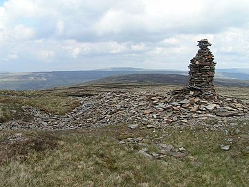
Cairn on Fountains Fell
|
|
| Highest point | |
| Elevation | 668 m (2,192 ft) |
| Prominence | 243 m (797 ft) |
| Parent peak | Pen-y-ghent |
| Listing | Marilyn |
| Geography | |
| Parent range | Pennines |
| OS grid | SD864716 |
| Topo map | OS Landranger 98 or OL 2 |
Fountains Fell is a mountain located in the beautiful Yorkshire Dales in England. It stands tall at about 668 meters (2,192 feet) high. Because of its height and how much it rises above the land around it (called its "prominence"), Fountains Fell is known as a Marilyn. This means it's a special type of hill or mountain in the British Isles.
There are actually a few tops on Fountains Fell. The main one is the highest. Another, called Fountains Fell South Top, is about 662 meters (2,172 feet) high. It's known as a Nuttall, which is another way to classify hills. A third, even further south, reaches 610 meters (2,001 feet). This makes it the most southerly 2,000-foot summit in the Pennines mountain range.
The eastern parts of Fountains Fell are looked after by the National Trust. This area is part of their Malham Tarn and Moor estate, which is a special place for nature.
History of Fountains Fell
The name Fountains comes from the Cistercian monks of Fountains Abbey. They owned this land in the 1200s. The monks used the fell for grazing their sheep.
Later, between 1790 and 1860, people mined coal on the summit of Fountains Fell. This coal was used to help melt lead in the area. You can still see signs of this mining today. There are old pits and shafts near the top. You might also find the remains of a building where they made coke, which is a type of fuel.
Walking the Pennine Way
The Pennine Way is a very long walking path in England. It crosses Fountains Fell a little north of the main summit. If you are walking north on the Pennine Way, Fountains Fell is about 85 miles (137 km) from the start of the path in Edale.
This is an important point on the Pennine Way. It's the first time the path climbs higher than Kinder Scout, which is another high point near the start of the trail.
To reach Fountains Fell from Malham village, it's about an 8-mile (13 km) walk along the Pennine Way. The path takes you past the amazing cliffs of Malham Cove. You also pass Malham Tarn before climbing up the eastern side of the fell.
After crossing Fountains Fell, the path goes down its western slopes. Then, it climbs up the southern ridge of Pen-y-ghent. This mountain is about 3.5 miles (5.6 km) further along the path. Pen-y-ghent is 694 meters (2,277 feet) high. Once you reach its summit, it becomes the highest point you've been on the Pennine Way so far!
Exploring Caves on Fountains Fell
Fountains Fell is also a popular spot for cavers. There are several interesting caves here. Some of these include Antler Hole, Dalehead Pot, Echo Hole, Fornagh Gill, Gingling Pot, Hammer Pot, and Magnetometer Pot. These caves offer exciting challenges for experienced cavers.
 | Georgia Louise Harris Brown |
 | Julian Abele |
 | Norma Merrick Sklarek |
 | William Sidney Pittman |


