High Cup Gill facts for kids
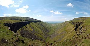
High Cup Gill is an amazing valley in northern England, found in Cumbria. It's often called High Cup Nick or just High Cup. This valley looks like a perfect "U" shape, carved deep into the side of the Pennines hills. It's part of the North Pennines Area of Outstanding Natural Beauty. Scientists believe this valley was formed by huge glaciers during past ice ages. It sits near Appleby-in-Westmorland, with Murton Fell to its southeast and Dufton Fell to the north.
What's in a Name?
The official map name for this valley is High Cup Gill. However, many people call it High Cup Nick. High Cup Nick actually refers to a specific spot at the top of the valley. This is where the stream, called Highcup Gill Beck, flows from a flat area called High Cup Plain and tumbles over the edge of High Cup Scar into the valley below.
The word 'Gill' comes from an old Norse word meaning a narrow valley or ravine. 'Beck' also comes from Norse and means a stream. You'll find these words used a lot in the hills of northern England. Looking southwest from High Cup Nick, you can see the beautiful Vale of Eden. This view is considered one of the best natural sights in northern England.
How High Cup Gill Was Formed
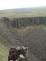
The impressive cliff at High Cup Scar is made from a type of rock called the Whin Sill. This is a hard, dark rock called dolerite. It formed a very long time ago, in the late Carboniferous period, when hot, melted rock pushed its way into older rocks and then cooled. You can see large pieces of this rock scattered down the slopes below the cliff.
One special rock pillar on the northern side of the valley is called Nichol's Chair. It's named after a local cobbler (someone who makes or fixes shoes). He supposedly sat on top of it to do his work as part of a bet!
The rocks that the Whin Sill pushed into are called the Alston Formation. These rocks are made up of many layers of limestone, sandstone, siltstone, and mudstone. At the very bottom of the valley, you can find even older rocks. These include sedimentary rocks from the Ravenstonedale Group and even older slates and sandstones from the Skiddaw Group. These date back to the Ordovician period.
Walking the Pennine Way
The famous Pennine Way walking path goes along the northern side of High Cup Gill. This part of the path is known as 'Narrow Gate'. It's a route that goes from Dufton east towards Maize Beck and Cauldron Snout.
The Pennine Way is a national trail that sometimes splits into two routes along Maize Beck. The southern route is the one that leads you past High Cup Nick. This walk is listed as one of the 100 best Pathfinder walks in Britain. It's an 8-mile walk and can be challenging, with an elevation gain of 1445 feet. The well-known fellwalker Alfred Wainwright described High Cup as "a great moment on the journey" in his book Pennine Way Companion.
The village of Dufton is located between two of the toughest parts of the Pennine Way. There are steep drops along the higher sections of the walk. The "helm wind," a strong local wind, can blow very powerfully through the valley.
The entire valley is considered "open country." This means that walkers generally have the right to walk freely here. This part of the Pennine Way is also a bridleway. This means it can be used by cyclists and horseriders too.
 | William Lucy |
 | Charles Hayes |
 | Cleveland Robinson |


