Windy Gyle facts for kids
Quick facts for kids Windy Gyle |
|
|---|---|
 |
|
| Highest point | |
| Elevation | 619 m (2,031 ft) |
| Prominence | 113 m (371 ft) |
| Listing | Hu,Tu,Sim, D, Hew, N,GT,DN,BL,Bg,Y,Cm |
| Geography | |
| Location | Scottish Borders, Northumberland, England/Scotland |
| Parent range | Cheviot Hills |
| OS grid | NT 85538 15210 |
| Topo map | OS Landranger 80 |
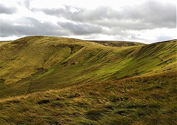
Windy Gyle is a mountain located in the Cheviot Hills. It sits right on the border between England and Scotland. Like other hills in this area, it has a rounded shape and is covered in green grass.
About Windy Gyle
Windy Gyle is special because it is the highest mountain summit directly on the border. However, the actual highest point on the border is a bit higher. That point is found on the western side of The Cheviot mountain. It's called Cairn Hill West Top, or sometimes Hangingstone Hill.
What's at the Top?
At the very top of Windy Gyle, you will find a pile of stones called a cairn. This cairn is named Russell's Cairn. It has a small dip in the middle. This dip is a good spot for about 15 people to shelter from the wind. The border between England and Scotland actually runs right through this cairn. You can see this on a map. Even though a fence often follows the border in other places, there isn't one here.
How to Climb Windy Gyle
One popular way to reach the top of Windy Gyle is by following the Pennine Way. This is a famous long-distance walking path that crosses the summit. You can also climb Windy Gyle from other directions. One route starts from the Coquet valley to the south, which is in England. Another way is from Cocklawfoot to the north, which is in Scotland.
Amazing Views
From the summit of Windy Gyle, you can enjoy fantastic views. Looking north, you can see across the Scottish Borders. You might even spot the Eildon Hills and the city of Edinburgh far away. If you look south, you will see the southern Cheviot Hills. Beyond them, you can see the North Pennines.
 | James Van Der Zee |
 | Alma Thomas |
 | Ellis Wilson |
 | Margaret Taylor-Burroughs |

