Airedale facts for kids

* Airedale to Ribblesdale 144 m (472 ft) near Barnoldswick.* Airedale to Pendle Water 165 m (541 ft) near Colne.* Airedale to Londsdale 166 m (545 ft) near Settle.
Airedale is a special area in Yorkshire, England. It's the valley, or dale, of the River Aire.
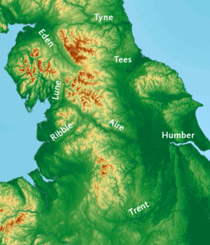
The valley starts where the river begins at Aire Head Springs in Malham. This spot is found in the beautiful Yorkshire Dales. From there, the valley stretches past towns like Skipton, Keighley, Bingley, and Shipley. It then goes through bigger cities like Leeds and Castleford. Finally, the River Aire joins the River Ouse at Airmyn.
This valley is very important because it offers easy, low-level routes through the middle of the Pennines mountains. These routes, known as the Aire Gap, lead towards the west coast of England.
Contents
History of Airedale Valley
How the Valley Was Formed
About 12,000 years ago, a huge glacier slowly moved back from the upper Aire valley. As it melted, it left behind a pile of rock and dirt called a moraine near Cononley. This created a large lake that reached as far north as Gargrave.
Later, people started to settle in the valley. This happened especially during the Iron Age. The people who lived in the Aire Valley and much of northern England were called the Brigantes by the Romans.
Transport Links Grow
Travel and trade became much easier in the 1700s and 1800s. This was thanks to new waterways like the Aire and Calder Navigation and the Leeds and Liverpool Canal.
Then, trains arrived from the 1830s onwards. During the 1900s, the roads in the valley were also greatly improved. All these changes helped the area grow and connect with other places.
Exploring the Airedale Area
A long time ago, Airedale was completely within the West Riding of Yorkshire. This was true from the river's source in Malhamdale all the way to Airmyn.
After some boundary changes in 1974, Airedale now begins in what is called North Yorkshire. The town of Airmyn is now part of the East Riding of Yorkshire.
Different Parts of the Valley
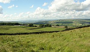
The upper part of the valley is known for its beautiful scenery. This area is part of the Yorkshire Dales (Malhamdale is inside the Yorkshire Dales National Park).
From Skipton to Knottingley, the valley becomes more industrial. Even though many factories have closed, some industry still remains. The section of the valley in East Yorkshire is flatter and has more farms.
River Aire's Journey
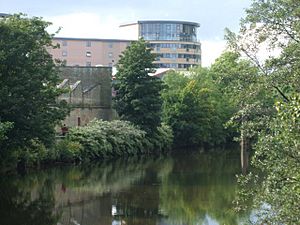
From Aire Springs, the river flows past Skipton and Keighley. It then goes through Bingley, Saltaire, Shipley, and into Leeds. In these areas, the river flows quickly. It is fed by many smaller streams and brooks.
After Leeds, the river's path changes. Through Castleford and Knottingley, and out to Airmyn, the river winds slowly. It flows across a wide, flat area called a floodplain.
What Airedale Includes
Airedale is generally thought of as all the areas right next to the River Aire. It also includes places near the smaller streams that flow into the river. For example, the Worth Valley and most of Bradford City are considered part of Airedale. This is because they are in the same river system.
Rocks and Land of Airedale
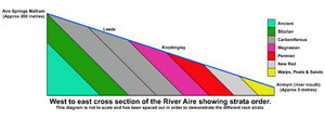
The upper part of Airedale, between Malham and Skipton, has a lot of Carboniferous limestone. This rock was pushed up by movements in the Earth.
The middle part, from Skipton to Knottingley, has peat and gritstone. Here, you can see steep valley walls with moorland on top. This is common between Skipton and Shipley.
The sandstone found between Skipton and Leeds was used to build many of the old buildings in this area. Other rocks like limestone, Coal, fireclay, and Ironstone helped power the growth of factories and industries.
Fun Places to Visit in Airedale
Airedale has many interesting places for visitors. One famous spot is the World Heritage Site of Saltaire village. It's a special place recognized for its history.
Other popular attractions include:
- The Keighley and Worth Valley Railway: A historic steam train ride.
- Bingley Five Rise Locks: A famous set of canal locks.
- Shipley Glen Tramway: An old tram that takes you up a hill.
- East Riddlesden Hall: A beautiful old manor house.
- Rodley Nature Reserve: A great place to see wildlife.
- Kirkstall Abbey: The ruins of an old monastery.
- The Royal Armouries (Leeds): A museum with amazing collections of weapons and armor.
- St Aidan's Nature Reserve: Another wonderful place for nature lovers.
- Fairburn Ings Nature Reserve: A bird sanctuary.
Industries in Airedale
Many of the old wool and cotton factories in the valley have been taken down. Others have been turned into homes. However, heavy industry still exists east of Leeds.
Two of the three large coal-fired power stations in the lower valley use water from the River Aire. Industries along the Aire include:
- Ferrybridge
- Eggborough
- Drax power stations
- Eggborough Saint Gobain glassworks
- Stolze and Allied Glass in Knottingley
- Kellingley Colliery (a former coal mine)
Leeds City Council has also created an "enterprise zone." This is a special area of 400 acres of redeveloped land along the Aire Valley. It stretches from the city centre to a motorway junction. This zone is home to several manufacturing and food companies.
What's Named After Airedale
The names Aire and Airedale are used for many different things and places.
- In the valley, you'll find Airedale General Hospital.
- There's also Aireborough, which is an area with towns mostly from another valley called Wharfedale.
- And Airedale is a part of the town of Castleford.
The area also gave its name to the Airedale Terrier. This is the largest type of dog in the terrier group. These dogs were first bred in the Airedale area in the 1800s.
See Also
- Aire Gap
 | Frances Mary Albrier |
 | Whitney Young |
 | Muhammad Ali |


