Gayle, North Yorkshire facts for kids
Quick facts for kids Gayle |
|
|---|---|
 Gayle Beck |
|
| OS grid reference | SD870893 |
| Civil parish | |
| Unitary authority |
|
| Ceremonial county | |
| Region | |
| Country | England |
| Sovereign state | United Kingdom |
| Post town | HAWES |
| Postcode district | DL8 |
| Police | North Yorkshire |
| Fire | North Yorkshire |
| Ambulance | Yorkshire |
| EU Parliament | Yorkshire and the Humber |
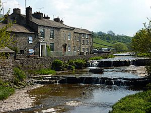
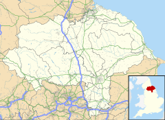
Gayle is a small village, also called a hamlet. It's located about 0.4 miles (0.6 km) south of a town called Hawes. You can find Gayle in a beautiful area of North Yorkshire, England, known as Wensleydale. Gayle is famous for its stream, called Gayle Beck, and an old mill. This mill was even shown on a BBC TV show called Restoration.
Contents
History of Gayle
Gayle started as a place where people farmed. In the late 1700s, more people moved there. The population grew to about 350 residents. They found jobs in local stone quarries and coal mines. Many also worked at a cotton mill powered by water from Gayle Beck.
The Gayle Beck Stream
Gayle Beck is a special stream. It flows steeply through Gayle and into Hawes. About 1 mile (1.6 km) upstream from the village, you can see the beautiful Aysgill waterfall. Over time, the number of people living in Gayle became smaller. Today, Gayle is part of the larger area of Hawes for counting its population.
Old Roads and Roman Connections
Long ago, Gayle was part of the Parish of Aysgarth. This area was known as the wapentake of Hang West. Hawes was a very small village until the late 1790s. At that time, a main road called the Richmond to Lancaster Turnpike was moved. It started going through Hawes instead of the moor south of Gayle. This change helped Hawes grow and become an important parish. Today, Gayle is part of the Hawes Parish in the Richmondshire district.
East of Gayle, there are old remains. People believe these are from a small Roman outpost. This outpost was likely connected to a larger Roman camp nearby in Bainbridge. An ancient road, the Cam High Fell road, passed close to Gayle. The village itself might have been a place where Gayle Beck was crossed. There is still a ford, a shallow place to cross the stream, west of Gayle Bridge. This bridge is a historic building. The main road through Gayle used to run east to west. The road connecting Gayle to Hawes was not built until 1829. This was part of a plan to create the Hawes to Kendal Turnpike.
Gayle's Unique Look
A famous writer named Nikolaus Pevsner described Gayle. He said it was "almost as intricate as an Italian stone village." He wrote this in his book The Buildings of England; Yorkshire, the North Riding. The oldest part of Gayle, built before the 1900s, became a special conservation area in 2001. Most of the newer houses are on the road leading north into Hawes.
The Methodist Church
Gayle once had a Methodist Church. It was built around 1755. There was also a different Methodist group linked to the Sandemanians from Scotland. Only their old graveyard, east of the chapel, remains today. The chapel building was later changed into the Gayle Village Institute. It is now a protected historic building.
Industry in Gayle
Gayle has a rich history of industry. People used the natural resources around them.
Gayle Mill
Gayle Mill was built in the 1780s. It is a very important historic building. It is a scheduled monument and came third in the BBC's 2004 Restoration TV show. The mill first spun cotton. Then, in 1878, it became a sawmill for cutting wood. It is the oldest cotton mill that still looks much like it did when it was built.
The mill has a special water turbine. It's called a Thomson Double-Vortex turbine. It was built by Williamson's of Kendal in 1878. People believe it's the oldest working water turbine in the world still in its original spot. The mill has been fixed up and is now open for visitors to explore. Water from Gayle Beck flows into the mill through a channel. This channel is about 100 meters (328 feet) long. It is covered with timber and is called a pentrough.
A millpond was also built for the mill. It is located south of the mill, next to the beck. This pond was used to collect water overnight when the stream flow was low. Then, the stored water could be released the next day to power the mill.
Other Local Industries
The hills and the valley of Sleddale, south and west of Gayle, provided coal and peat. These were used by local people for heating their homes. Many buildings in Gayle and Hawes were built using stone. This stone came from quarries like Scar Head and East Shaw. These quarries are south of the village.
See also
- Listed buildings in Hawes
 | Calvin Brent |
 | Walter T. Bailey |
 | Martha Cassell Thompson |
 | Alberta Jeannette Cassell |


