
River Swale facts for kids
Quick facts for kids River Swale |
|
|---|---|

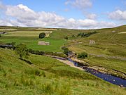
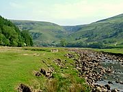
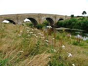
The River Swale near Richmond
|
|
.png) |
|
| Country | England |
| Physical characteristics | |
| Main source | Confluence of Birkdale Beck and Great Sleddale Beck. 366 m (1,201 ft) 54°24′11″N 2°13′22″W / 54.403019°N 2.222681°W |
| River mouth | River Ure, near Myton-on-Swale, North Yorkshire 11 m (36 ft) 54°05′16″N 1°20′36″W / 54.087853°N 1.343408°W |
| Length | 117.8 km (73.2 mi) |
The River Swale is a very important river in Yorkshire, England. It flows into the River Ure, which then becomes the River Ouse. Finally, its waters reach the North Sea through the Humber Estuary. The river gives its name to Swaledale, which is the beautiful valley it flows through.
The River Swale is known for being one of the fastest-flowing rivers in England. Its water levels can rise very quickly, sometimes as much as 10 feet (3 m) in just 20 minutes! This shows how powerful the river can be.
Contents
Journey of the River Swale
The River Swale begins where two smaller streams, Birkdale Beck and Great Sleddale Beck, meet. From there, it starts its long journey.
From Source to Richmond
The river first flows north-east, passing old lead mines. It then turns east, creating many beautiful waterfalls. You can see Wain Wath Force, Hoggarts Leap, and Catrake Force near Keld. Further along, it flows over East Gill Force and Kisdon Force.
After Swinner Gill joins, the river turns sharply south towards the village of Muker. Here, Straw Beck adds its water, and the river turns east again. It then flows past Gunnerside, Feetham, Healaugh, Reeth, and Grinton. The river then gently curves south-east and east below Marrick, before heading north-east and then north past Marske.
Flowing to the Ure
The Swale turns east again near Hudswell. It then reaches the main town in the valley, Richmond. After Richmond, the river makes long, winding turns (called meanders) towards the south-east. It flows past Brompton-on-Swale and goes under the A1 road at Catterick Bridge.
The river continues its journey south, passing Catterick. It keeps making long, winding turns past Thrintoft and Morton-on-Swale. As it flows more directly south, it is joined by the River Wiske. It then passes Skipton-on-Swale, Catton, Topcliffe, and Asenby. Finally, it flows past Helperby and Myton-on-Swale before joining the River Ure.
Nature and Wildlife
The River Swale and its valley are home to many different plants and animals. The area has various types of woodlands, including broadleaf, mixed, and conifer trees. You can also find hay meadows and grasslands.
Plants and Trees
Along the river, you might see trees like ash, birch, rowan, and bird cherry. Common shrubs include hawthorn, hazel, and holly. There are also smaller numbers of yew and sycamore.
In planted areas, you'll find Pine, larch, and spruce. Near the river banks, alder and willow are common. The hay meadows are full of colorful buttercups and wood cranesbill flowers.
Rocks and Landforms
The land around the River Swale has interesting rock formations. The upper parts of the river flow over different types of rock, including Carboniferous, Permian, and Triassic rocks. These rocks are very old and sit on even older layers.
Minerals and Glaciers
These rocks are rich in minerals like galena (which contains lead), sphalerite, chalcopyrite, and bravoite. You can also find fluorite, barite, witherite, calcite, dolomite, and barytocalcite.
Along the valley sides, you can see layers of limestone and gritstone. Small amounts of coal have also been found and mined, especially near Tan Hill. During the last Ice Age, a huge glacier shaped the valley. It made the valley wider and changed the river's path in places like Keld. The glacier also carved out the Kisdon gorge. You can still see signs of the glacier, like piles of rock and dirt called moraines, further down the valley near Gunnerside and Grinton Bridge.
A Look Back in Time
People have lived in the River Swale valley for a very long time. The oldest signs of people living here date back to the Mesolithic and Neolithic Ages, when flint tools and arrowheads were used.
Ancient Times and Mining
Around Harkerside, there are small stone circles from the Bronze Age. There are also old defensive earthworks from the Iron Age. People were mining lead here as far back as Roman times. This mining slowed down until after the Norse (Danish) invasions.
In the 12th and 13th centuries, lead became very important for building churches. So, mining in the valley increased again. You can still see signs of an 18th-century mining method called 'hushing'. This involved building temporary dams across small streams (gills). When the dams were released, the rush of water would wash away the topsoil, revealing the valuable ore veins.
Early Settlements and Baptisms
The valley was once part of a Celtic kingdom called Catraeth. In the late 500s, the Angles invaded and took over the settlement at Catraeth (now Catterick). Later, Norsemen also settled in the valley.
After the Norman invasion, the land was given to Alan the Red of Brittany. He built Richmond Castle between 1071 and 1091. This castle stands on a high cliff overlooking the River Swale.
In the 7th century, it is said that St Paulinus baptized thousands of people in the River Swale at Brompton-on-Swale and Brafferton. Because so many people were baptized there, some writers in the 1800s called the Swale England's River Jordan. Even today, mass baptisms sometimes happen in the river near the Catterick Bridge area.
What the River Swale Provides
For many centuries, lead mining and cattle farming were the main ways people made a living in the Swale valley. However, by the end of the 1800s, these industries faced competition from other parts of the world and began to decline. Some crop farming also took place, especially during warm periods in the 13th century.
Tourism Today
Today, tourism is a big part of the valley's economy. Many people visit to enjoy the beautiful scenery and outdoor activities. The Yorkshire Dales Cycle Way follows the valley between Fremington and Gunnerside, perfect for bike riders. The famous Coast to Coast Walk passes through Richmond to Reeth. Another well-known trail, the Pennine Way, crosses the upper valley from Buttertubs Pass to Muker.
Gallery
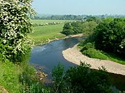
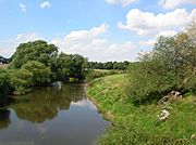
- Along the River Swale
-
Whitsundale Beck joins the River Swale
-
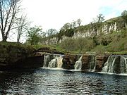
Wain Wath Force, near Keld, with the limestone cliffs of Cotterby Scar in the background.
-
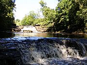
Catrake Force
-
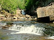
Kisdon Force on River Swale
-
River Swale near Muker
-
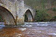
River Swale flowing under Downholme Bridge
-

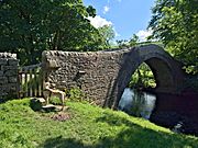
Grinton Bridge
-
Ivelet Bridge
-
River Swale from Catterick Bridge
-
Morton Bridge, A684 Crossing the River Swale
-
River Swale near Brompton-on-Swale
-
River Swale from bridge near Brafferton


Places Along the Swale
Towns and Villages
- Keld
- Muker
- Gunnerside
- Low Row
- Reeth
- Grinton
- Richmond
- Brompton-on-Swale
- Catterick Bridge
- Catterick
- Great Langton
- Little Fencote
- Morton-on-Swale
- Gatenby
- Maunby
- Pickhill
- Skipton-on-Swale
- Catton
- Baldersby St James
- Topcliffe
- Cundall
- Fawdington
- Brafferton
- Helperby
- Myton-on-Swale
Streams Joining the Swale
- Holme Ash Gill 54°24′11.37″N 2°13′6.08″W / 54.4031583°N 2.2183556°W
- Little Ash Gill 54°24′20.38″N 2°12′32.63″W / 54.4056611°N 2.2090639°W
- Great Ash Gill 54°24′26.33″N 2°12′6.83″W / 54.4073139°N 2.2018972°W
- Whitsunudale Beck 54°24′27.99″N 2°11′50.00″W / 54.4077750°N 2.1972222°W
- Blackburn Beck 54°24′33.11″N 2°10′48.27″W / 54.4091972°N 2.1800750°W
- Stonesdale Beck 54°24′31.73″N 2°10′28.76″W / 54.4088139°N 2.1746556°W
- Oldfield Gutter 54°24′5.88″N 2°9′6.11″W / 54.4016333°N 2.1516972°W
- Swinner Gill 54°23′56.07″N 2°8′36.93″W / 54.3989083°N 2.1435917°W
- West Arn Gill 54°23′44.50″N 2°8′25.28″W / 54.3956944°N 2.1403556°W
- Straw Beck 54°22′35.40″N 2°8′3.83″W / 54.3765000°N 2.1343972°W
- Routin Gill 54°22′29.20″N 2°7′25.83″W / 54.3747778°N 2.1238417°W
- Oxnop Gill 54°22′32.11″N 2°6′17.05″W / 54.3755861°N 2.1047361°W
- Shore Gill 54°22′34.86″N 2°5′56.92″W / 54.3763500°N 2.0991444°W
- Gunnerside Gill 54°22′32.05″N 2°4′42.41″W / 54.3755694°N 2.0784472°W
- Haverdale Beck 54°22′20.68″N 2°2′15.51″W / 54.3724111°N 2.0376417°W
- Mirk Gill 54°22′18.48″N 2°1′46.33″W / 54.3718000°N 2.0295361°W
- Birks Gill 54°22′19.31″N 2°1′44.01″W / 54.3720306°N 2.0288917°W
- Scabba Wath 54°22′50.16″N 1°59′15.05″W / 54.3806000°N 1.9875139°W
- Barney Beck 54°22′53.87″N 1°58′37.77″W / 54.3816306°N 1.9771583°W
- Arkle Beck 54°22′55.33″N 1°56′4.60″W / 54.3820361°N 1.9346111°W
- Cogden Beck 54°22′46.47″N 1°54′45.42″W / 54.3795750°N 1.9126167°W
- Hags Gill 54°22′25.15″N 1°53′54.76″W / 54.3736528°N 1.8985444°W
- Gill Beck 54°22′32.83″N 1°51′18.93″W / 54.3757861°N 1.8552583°W
- Gill Beck 54°22′32.83″N 1°51′18.93″W / 54.3757861°N 1.8552583°W
- Oxque Beck 54°23′4.36″N 1°50′23.91″W / 54.3845444°N 1.8399750°W
- Marske Beck 54°23′46.83″N 1°49′42.70″W / 54.3963417°N 1.8285278°W
- Clapgate Beck 54°24′17.93″N 1°49′20.56″W / 54.4049806°N 1.8223778°W
- Sand Beck 54°23′53.03″N 1°43′8.34″W / 54.3980639°N 1.7189833°W
- Colburn Beck 54°23′31.10″N 1°41′9.56″W / 54.3919722°N 1.6859889°W
- Skeeby Beck 54°23′36.73″N 1°40′27.51″W / 54.3935361°N 1.6743083°W
- Brough Beck 54°22′15.05″N 1°36′38.62″W / 54.3708472°N 1.6107278°W
- Fiddale Beck 54°21′52.02″N 1°33′55.71″W / 54.3644500°N 1.5654750°W
- Kiplin Beck 54°21′49.43″N 1°33′21.67″W / 54.3637306°N 1.5560194°W
- The Stell 54°21′28.32″N 1°32′15.85″W / 54.3578667°N 1.5377361°W
- Mill Beck 54°20′14.50″N 1°31′47.21″W / 54.3373611°N 1.5297806°W
- Bedale Beck 54°18′15.21″N 1°30′50.03″W / 54.3042250°N 1.5138972°W
- River Wiske 54°14′38.19″N 1°26′19.94″W / 54.2439417°N 1.4388722°W
- Cod Beck 54°10′3.88″N 1°21′58.63″W / 54.1677444°N 1.3662861°W
- Crakehill Beck 54°9′7.14″N 1°20′22.01″W / 54.1519833°N 1.3394472°W
- Cundall Beck 54°8′13.20″N 1°20′18.10″W / 54.1370000°N 1.3383611°W
- Arn Gill 54°23′18″N 2°08′27″W / 54.38847°N 2.14071°W
Bridges Over the Swale
- High Bridge (B6270) 54°24′26.87″N 2°12′1.64″W / 54.4074639°N 2.2004556°W
- Low Bridge 54°24′33.78″N 2°11′23.97″W / 54.4093833°N 2.1899917°W
- Park Bridge 54°24′31.32″N 2°10′38.17″W / 54.4087000°N 2.1772694°W
- Ivelet Bridge 54°22′32.50″N 2°6′16.39″W / 54.3756944°N 2.1045528°W
- Gunnerside Great Bridge (B6270)54°22′32.31″N 2°4′43.47″W / 54.3756417°N 2.0787417°W
- Isles Bridge 54°22′22.13″N 2°2′11.46″W / 54.3728139°N 2.0365167°W
- Scabba Wath Bridge 54°22′49.35″N 1°59′31.68″W / 54.3803750°N 1.9921333°W
- Grinton Bridge (B6270) 54°22′55.86″N 1°55′47.78″W / 54.3821833°N 1.9299389°W
- Downholme Bridge 54°23′16.77″N 1°49′36.49″W / 54.3879917°N 1.8268028°W
- Lownethwaite Bridge (A6108) 54°24′5.29″N 1°46′34.13″W / 54.4014694°N 1.7761472°W
- Bridge Street, Richmond 54°24′1.96″N 1°44′25.15″W / 54.4005444°N 1.7403194°W
- Station Road, Richmond (A6136) 54°24′14.23″N 1°43′50.77″W / 54.4039528°N 1.7307694°W
- A1(M) 54°23′17.81″N 1°39′21.14″W / 54.3882806°N 1.6558722°W
- Catterick Bridge (A6055) 54°23′21.44″N 1°39′5.25″W / 54.3892889°N 1.6514583°W
- Stoney Leigh Bridge 54°21′46.06″N 1°33′15.41″W / 54.3627944°N 1.5542806°W
- Bridge Street, Richmond 54°24′1.96″N 1°44′25.15″W / 54.4005444°N 1.7403194°W
- Swale Bridge (Wensleydale Railway) 54°19′24.12″N 1°30′38.12″W / 54.3233667°N 1.5105889°W
- Morton Bridge (A684) 54°19′14.45″N 1°30′41.00″W / 54.3206806°N 1.5113889°W
- Skipton Bridge (A61) 54°12′45.38″N 1°26′37.19″W / 54.2126056°N 1.4436639°W
- Topcliffe Bridge (A167) 54°10′40.53″N 1°23′29.71″W / 54.1779250°N 1.3915861°W
- A168 54°10′27.26″N 1°23′3.83″W / 54.1742389°N 1.3843972°W
- Thornton Bridge 54°8′12.15″N 1°20′19.75″W / 54.1367083°N 1.3388194°W
- Myton Bridge 54°5′41.16″N 1°20′5.23″W / 54.0947667°N 1.3347861°W
See also
 In Spanish: Río Swale para niños
