Great Langton facts for kids
Quick facts for kids Great Langton |
|
|---|---|
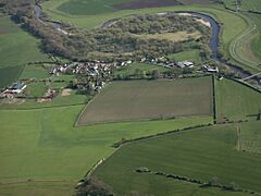
 Aerial view of Great Langton and the River Swale |
|
| Area | 3.04 km2 (1.17 sq mi) |
| Population | 202 (Including Kiplin and Whitwell. 2011 Census) |
| • Density | 66/km2 (170/sq mi) |
| OS grid reference | SE295964 |
| Civil parish |
|
| Unitary authority |
|
| Ceremonial county | |
| Region | |
| Country | England |
| Sovereign state | United Kingdom |
| Post town | NORTHALLERTON |
| Postcode district | DL7 |
| Dialling code | 01609 |
| Police | North Yorkshire |
| Fire | North Yorkshire |
| Ambulance | Yorkshire |
| EU Parliament | Yorkshire and the Humber |
| UK Parliament |
|
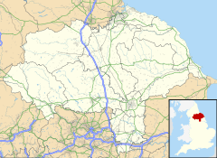
Great Langton is a small village and civil parish in North Yorkshire, England. It sits on the northern bank of the River Swale. The village is located between Scorton and Northallerton. It was once known as Langton-upon-Swale.
In Great Langton, you'll find St Wilfrid's Church. There used to be a chapel and a school, but these buildings are now homes. The village pub, which was called The Wishing Well, closed in 2004.
The village is also close to Kiplin Hall. This grand old house was built by George Calvert, 1st Baron Baltimore. He was the person who founded Maryland in America!
Contents
What's in a Name?
The name 'Great Langton' comes from old English words. It means 'Long farm' or 'Long settlement'. 'Lang' was an old Saxon word for 'long', and 'Tun' meant 'town'. It's called Great Langton because there is another village nearby called Little Langton.
Nature and Wildlife
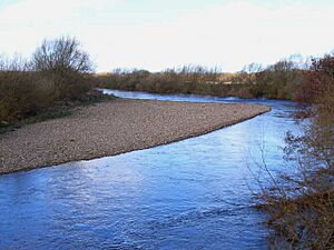
Great Langton has special areas important for nature. These are called Sites of Importance for Nature Conservation. They include Great Langton Pond and parts of the River Swale.
Great Langton Pond is a great spot for birdwatching and fishing. You can find fish like Tench, Bream, and Pike there.
The River Swale sometimes floods, so the Environment Agency keeps a close eye on it. Many ducks visit the village, especially in winter. They travel about 2,000 kilometres (1,200 miles) from central CIS countries. They arrive around mid-September and leave in April.
Poole's Waist is an oxbow lake near the River Swale. This is a U-shaped lake formed when a wide loop of a river is cut off. River water still flows into Poole's Waist when there is a lot of rain.
A Look Back in Time
People have lived in the Great Langton area for a very long time. In the early days, there wasn't much human activity. But there were signs of forest fires, possibly from early people.
Farming started later and changed the land a lot. Clearing forests for farms caused changes in the river's soil. This shows that Great Langton has a long history of rural life. There's also an old, unused quarry here. This means people once dug for sand and gravel from the old river bed.
Great Langton officially became its own parish in 1823.
Community and Faith
Most people in Great Langton are Christian. The village holds a church fete every year to raise money for St Wilfrid's Church. Even though the church is still active, it has seen fewer people attending over the years.
Working and Living
Many people in Great Langton have jobs in 'small roles'. Farming is a big employer here, followed by shops and sales. Most homes in the village own at least one car. Many houses are owned by the people who live in them, while some are rented. Only a small number of people are looking for work.
Getting Around
Only a few people in Great Langton use public transport to get to work. However, there are bus services to nearby places like Richmond, Yafforth, and Northallerton. From Northallerton, you can catch regular train services to London.
Weather in Great Langton
The British Isles have a maritime climate. This means they have fairly cool summers and mild winters. North Yorkshire, where Great Langton is, is a bit warmer and sunnier in summer. Winters are colder and have more frost.
Because it's inland and protected by the Pennines mountains, North Yorkshire is one of the driest counties in the UK. It gets less than 600 millimetres (24 inches) of rain each year. On average, the area gets about three hours and 42 minutes of sunshine each day.
| Climate data for Leeming (North Yorkshire): elevation: 32 m (105 ft) Average maximum and minimum temperatures, and average rainfall recorded between 1991 and 2020 by the Met Office. |
|||||||||||||
|---|---|---|---|---|---|---|---|---|---|---|---|---|---|
| Month | Jan | Feb | Mar | Apr | May | Jun | Jul | Aug | Sep | Oct | Nov | Dec | Year |
| Mean daily maximum °C (°F) | 7.0 (44.6) |
7.8 (46.0) |
10.2 (50.4) |
13.0 (55.4) |
16.0 (60.8) |
18.7 (65.7) |
21.0 (69.8) |
20.5 (68.9) |
17.9 (64.2) |
13.9 (57.0) |
9.9 (49.8) |
7.2 (45.0) |
13.6 (56.5) |
| Mean daily minimum °C (°F) | 1.1 (34.0) |
1.1 (34.0) |
2.2 (36.0) |
3.9 (39.0) |
6.5 (43.7) |
9.6 (49.3) |
11.6 (52.9) |
11.4 (52.5) |
9.3 (48.7) |
6.5 (43.7) |
3.4 (38.1) |
1.0 (33.8) |
5.65 (42.17) |
| Average precipitation mm (inches) | 53.8 (2.12) |
44.0 (1.73) |
39.4 (1.55) |
46.2 (1.82) |
43.8 (1.72) |
58.8 (2.31) |
56.2 (2.21) |
65.3 (2.57) |
56.9 (2.24) |
65.0 (2.56) |
64.8 (2.55) |
59.5 (2.34) |
653.7 (25.74) |
| Average precipitation days (≥ 1.0 mm) | 12.0 | 10.0 | 8.5 | 9.0 | 8.7 | 9.4 | 9.3 | 10.1 | 9.1 | 11.1 | 12.2 | 11.9 | 121.4 |
| Mean monthly sunshine hours | 58.1 | 81.7 | 121.5 | 153.8 | 195.0 | 175.9 | 185.5 | 171.2 | 132.7 | 93.4 | 63.7 | 54.2 | 1,486.7 |
| Source: Met Office | |||||||||||||
 | Bessie Coleman |
 | Spann Watson |
 | Jill E. Brown |
 | Sherman W. White |


