Northallerton facts for kids
Quick facts for kids Northallerton |
|
|---|---|
| Town | |
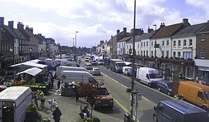
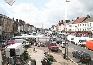 Northallerton High Street on market day |
|
| Area | 33.41 km2 (12.90 sq mi) |
| Population | 16,832 (2011 census) |
| • Density | 503.8/km2 (1,305/sq mi) |
| OS grid reference | SE371937 |
| Unitary authority |
|
| Ceremonial county | |
| Region | |
| Country | England |
| Sovereign state | United Kingdom |
| Post town | NORTHALLERTON |
| Postcode district | DL6, DL7 |
| Dialling code | 01609 |
| Police | North Yorkshire |
| Fire | North Yorkshire |
| Ambulance | Yorkshire |
| EU Parliament | Yorkshire and the Humber |
| UK Parliament |
|
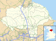
Northallerton (/nɔːrˈθælərtən/ NOR-thal-ƏR-tən) is a busy market town and civil parish in North Yorkshire, England. It is located near the River Wiske in an area called the Vale of Mowbray. In 2011, about 16,832 people lived there. Northallerton is an important administrative centre for the York and North Yorkshire Combined Authority and North Yorkshire Council.
People have lived in Northallerton since Roman times. The town became more important from the 11th century. This happened when King William II gave land here to the Bishop of Durham. It then grew into a key religious centre. A famous battle, the Battle of the Standard, was fought nearby in 1138. Up to 12,000 Scottish soldiers died in this battle.
Before railways, Northallerton was a vital stop for coaches. These coaches travelled on the main road between Edinburgh and London.
Contents
Northallerton: A Historic Market Town
Early History of Northallerton
Northallerton was first settled by the Romans. This was because it was close to a Roman road. There is proof that the Romans had a signal station on Castle Hills, west of the town. This station was part of their postal system. A path connecting Hadrian's Wall with Eboracum (York) also went through the nearby village of Brompton.
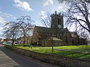
The first church in Northallerton was built by St Paulinus of York. This was in the early 7th century, where the All Saints Parish Church stands today. It was made of wood. Later, in 855, a stone church was built on the same spot. Pieces of this Angle church have been found during repair work.
An Anglo-Saxon town called Alvertune grew here. In 865, it was the site of battles between King Elfrid and his brother Alfred against Danish kings. Later, in the 10th century, Danes settled in Romanby and Brompton. You can see some beautiful English stone carvings from this time, called the Brompton Hogbacks, in Brompton Parish Church.
In the Domesday Book, Norman writers called the settlement Alvertune, Aluertune, and Alretone. There was also an area called the Alvertune wapentac, which was named after the town.
The town's name might come from Aelfere, meaning "Aelfere's farm". Or it could be from the Alder trees that grew nearby. The "North" was added in the 12th century. This was to tell it apart from Allerton Mauleverer, which is about 25 miles (40 kilometres) to the south.
Because it was on a major route, Northallerton often saw fighting. In 1069, William the Conqueror's armies destroyed much of the area. Northallerton was almost completely ruined or emptied of people. The Domesday Book later described it as "put down as waste."
The Battle of the Standard
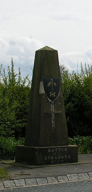
On August 22, 1138, English forces fought a Scottish army. This battle happened on Cowton Moor, about 2 mi (3 km) north of Northallerton. It was the first big battle between the Scots and the English after the Norman conquest. It was also a key battle in the civil war between King Stephen and Empress Matilda.
The English army was called together by Archbishop Thurstan of York. He gathered local soldiers and armies from Yorkshire and the North Midlands. They stood around a chariot that held a ship's mast. This mast carried the holy banners of St Peter, St John of Beverley, St Wilfrid of Ripon, and St Cuthbert. This standard-bearing chariot gave the battle its name.
King David of Scotland had entered England to support his niece, Empress Matilda. She was seen as the rightful heir to the English throne. The Scottish armies had already taken Cumberland and Northumberland. They also captured Carlisle and Bamburgh Castle. The English were in a strong defensive spot on a hill. King David decided to attack, thinking his larger army (16,000 Scots against 10,000 Englishmen) would win.
But repeated attacks by Scottish soldiers failed against the English archers. Up to 12,000 Scots were lost. An attack by Scottish knights had some early success but fell back. The battle ended when King David's reserve soldiers left. He had to retreat. The English did not chase them. Even with their losses, the Scots were able to gather enough forces to attack and capture Wark Castle. The English victory made sure that Northern England was safe.
Important Buildings and Places
Soon after he became king, William Rufus gave Northallerton to the Bishop of Durham. Under the bishops' care, the town grew. It became a home for the bishops. In 1130, a castle was built on the west side of town. It was expanded in 1142 and again in 1173. But King Henry II ordered it to be torn down in 1177.
A stronger, fortified palace with a moat was built on the same site in 1199. This palace became an important centre for managing the bishops' lands in Yorkshire. It was also a regular stopping place for kings and other important visitors. The palace fell into ruin by 1658. Today, the site is a cemetery.
In 1318, the Scots destroyed the town. A Carmelite priory (a type of monastery) was founded in 1354. But it was taken down after the dissolution of the monasteries in 1538. The land was later used for farming. In 1857, a workhouse was built there. Now, the Friarage Hospital stands on this site. Its name comes from the old friary.
In 2006, during building work, archaeologists found the remains of eight monks and other old items.
Law and Order in Northallerton
A house of correction (a type of prison) opened in 1783. This became HM Prison Northallerton. It was used as a prison for adults, young offenders, and military prisoners. The prison closed in 2013. Part of it has been taken down. It once had the world's largest treadmill for prisoners. Today, the former prison site has two shops, Iceland and Lidl.
The local courts were held in Northallerton from the 17th century. In 1875, a special courthouse was built next to the prison. When the North Riding Constabulary (police force) started in 1856, Northallerton was chosen as its headquarters. The police headquarters moved to Racecourse Lane in 1910. The court moved opposite it in 1936. The old court and police buildings were taken down in the 1990s.
When the Poor Law system began, a workhouse was set up in town. This building is now part of the Friarage Hospital. The Thirsk Road drill hall opened in 1911, just before the First World War.
How Northallerton is Governed
The old parish of Northallerton covered a large area. This included the villages of Romanby, Brompton, Deighton, and High Worsall. These became separate civil parishes in the 19th century.
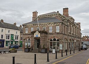
Northallerton has a town council with 12 councillors. These councillors are elected from four different areas of the town. The town council works from Northallerton Town Hall.
Northallerton has been twinned with Ormesson-sur-Marne, a town near Paris, since 1994.
In 1889, the North Riding of Yorkshire became an administrative county. In 1894, it was divided into different types of districts. After a review of local government in 1974, the North Riding was no longer an administrative county. The district council of Hambleton was formed. This combined Northallerton Urban District with several rural districts. This new district became part of the non-metropolitan county of North Yorkshire.
Since 2023, North Yorkshire Council has handled both local and county-level services. The York and North Yorkshire Combined Authority started its work on February 1, 2024. The first Mayor of York and North Yorkshire will be chosen in May 2024.
Northallerton used to be a parliamentary borough. It sent two Members of Parliament (MPs) to the House of Commons until 1832. After 1832, it sent one MP. In 1885, the area became part of the Richmond division. The current MP for Richmond is Rishi Sunak of the Conservative Party. He has held the seat since 2015. Sunak was also the Prime Minister between 2022 and 2024. This area has been a strong hold for the Conservative Party since 1929.
Geography and Climate
Northallerton's Location
| Place | Distance | Direction | |
|---|---|---|---|
| London | 203 miles (327 km) | South | Capital |
| York | 30 miles (48 km) | South east | Historic county town |
| Durham | 30 miles (48 km) | North | Historic bishopric centre |
| Middlesbrough | 18 miles (29 km) | North east | |
| Ripon | 14 miles (23 km) | South west | Closest city |
Northallerton is north of the Vale of York in the Vale of Mowbray. It is just south of County Durham. To the west are the Pennines, hills that rise to about 2,000 ft (610 m). To the east are the North York Moors, which rise to about 1,500 ft (460 m). These hills affect the weather in the area.
The River Wiske, a smaller river that flows into the River Swale, passes west of the town. Smaller streams like Brompton Beck, Turker Beck, Willow Beck, and North Beck flow through Northallerton. Even though they are small, these streams have caused flash floods in Northallerton and Brompton village in recent years.
Weather in Northallerton
The British Isles have a maritime climate. This means they have fairly cool summers and mild winters. Compared to other parts of the UK, the Vale of York is a bit warmer and sunnier in summer. It is also colder and frostier in winter. North Yorkshire is one of the driest counties in the UK. It gets about 600 mm (24 in) of rain each year. The area gets about three hours and 42 minutes of sunshine each day on average.
Sometimes, strong winds can blow down from the Pennines to the west. These winds can reach over 70 mph, especially in winter and spring. In winter, thick, lasting fog can form between the Pennines and the North York Moors. This fog can sometimes stay for several days.
The closest official weather station is Leeming, about 5 mi (8 km) west of Northallerton. The highest temperature recorded there was 38.8 °C (101.8 °F) in July 2022. The lowest was −17.9 °C (−0.2 °F) in December 2010.
| Climate data for Leeming, elevation: 32 m (105 ft), 1991–2020 normals, extremes 1965–present | |||||||||||||
|---|---|---|---|---|---|---|---|---|---|---|---|---|---|
| Month | Jan | Feb | Mar | Apr | May | Jun | Jul | Aug | Sep | Oct | Nov | Dec | Year |
| Record high °C (°F) | 14.1 (57.4) |
15.9 (60.6) |
21.2 (70.2) |
24.6 (76.3) |
27.2 (81.0) |
30.0 (86.0) |
38.8 (101.8) |
33.5 (92.3) |
28.9 (84.0) |
26.1 (79.0) |
19.0 (66.2) |
16.3 (61.3) |
38.8 (101.8) |
| Mean daily maximum °C (°F) | 7.0 (44.6) |
7.9 (46.2) |
10.2 (50.4) |
13.0 (55.4) |
16.0 (60.8) |
18.7 (65.7) |
21.0 (69.8) |
20.5 (68.9) |
17.9 (64.2) |
13.8 (56.8) |
9.9 (49.8) |
7.2 (45.0) |
13.6 (56.5) |
| Daily mean °C (°F) | 4.0 (39.2) |
4.5 (40.1) |
6.2 (43.2) |
8.4 (47.1) |
11.3 (52.3) |
14.1 (57.4) |
16.3 (61.3) |
16.0 (60.8) |
13.6 (56.5) |
10.2 (50.4) |
6.6 (43.9) |
4.1 (39.4) |
9.6 (49.3) |
| Mean daily minimum °C (°F) | 1.1 (34.0) |
1.1 (34.0) |
2.2 (36.0) |
3.9 (39.0) |
6.5 (43.7) |
9.6 (49.3) |
11.6 (52.9) |
11.4 (52.5) |
9.3 (48.7) |
6.5 (43.7) |
3.4 (38.1) |
1.0 (33.8) |
5.7 (42.3) |
| Record low °C (°F) | −17.3 (0.9) |
−14.8 (5.4) |
−9.0 (15.8) |
−5.7 (21.7) |
−3.8 (25.2) |
1.4 (34.5) |
3.5 (38.3) |
2.7 (36.9) |
0.4 (32.7) |
−4.2 (24.4) |
−10.4 (13.3) |
−17.9 (−0.2) |
−17.9 (−0.2) |
| Average precipitation mm (inches) | 53.8 (2.12) |
44.1 (1.74) |
39.4 (1.55) |
46.2 (1.82) |
43.8 (1.72) |
58.8 (2.31) |
56.2 (2.21) |
65.3 (2.57) |
56.9 (2.24) |
65.0 (2.56) |
64.8 (2.55) |
59.5 (2.34) |
653.7 (25.74) |
| Average precipitation days (≥ 1.0 mm) | 12.0 | 10.1 | 8.5 | 9.1 | 8.7 | 9.4 | 9.3 | 10.1 | 9.1 | 11.1 | 12.2 | 11.9 | 121.4 |
| Mean monthly sunshine hours | 58.2 | 81.7 | 121.5 | 153.8 | 195.0 | 175.9 | 185.5 | 171.2 | 132.7 | 93.4 | 63.7 | 54.2 | 1,486.7 |
| Source 1: Met Office | |||||||||||||
| Source 2: ECA&D | |||||||||||||
People and Economy
Who Lives in Northallerton?
In 2001, Northallerton had 15,741 people living there. This was 18.5% of the total population of Hambleton District. The town has a population density of about 674 inhabitants per square kilometre (1,750/sq mi). This is higher than the average for England. There are more females (8,203) than males (7,538) in the town. Most residents (98.5%) were born in the United Kingdom.
Compared to the rest of England, Northallerton has fewer people born outside the UK. It also has fewer people from ethnic minority groups. However, it has more people over 65 years old than the average.
| Northallerton | Hambleton District | Yorkshire and the Humber | England | |
|---|---|---|---|---|
| Total population | 15,741 | 84,111 | 4,964,833 | 49,138,831 |
| By ethnic grouping | ||||
| White | 99% | 99.2% | 93.5% | 91% |
| Asian | 0.3% | 0.1% | 4.5% | 4.6% |
| Black | ~0% | 0.1% | 0.7% | 2.3% |
| Chinese | 0.2% | 0.2% | 0.4% | 0.9% |
| By religious grouping | ||||
| Buddhist | 0.1% | 0.1% | 0.1% | 0.3% |
| Christian | 81.8% | 79.6% | 73.1% | 71.7% |
| Muslim | 0.2% | 0.1% | 0.4% | 3.1% |
| Hindu | 0.2% | 0.1% | 0.3% | 1.1% |
| Jewish | ~0% | ~0% | 0.2% | 0.5% |
| Sikh | 0% | ~0% | 0.4% | 0.7% |
| Other religions | 0.1% | 0.1% | 0.2% | 0.3% |
| No religion/no religion stated | 17.7% | 16.5% | 21.9% | 22.3% |
| Other categories | ||||
| Foreign born | 1.5% | 2.28% | 5.25% | 9.2% |
| Over 65 years old | 18.3% | 17.5% | 16.1% | 16% |
| Unemployed | 2.2% | 2.0% | 3.7% | 3.3% |
The town's population grew a lot in the early 19th century and again in the 20th century. Between 1961 and 1991, the population more than doubled. The drop in population between 1851 and 1871 happened because railways became popular, and coach travel declined.
| Year | 1801 | 1811 | 1821 | 1831 | 1841 | 1851 | 1861 | 1871 | 1881 | 1891 | 1901 | 1911 | 1921 | 1931 | 1951 | 1961 | 1971 | 1981 | 1991 | 2001 | 2011 |
|---|---|---|---|---|---|---|---|---|---|---|---|---|---|---|---|---|---|---|---|---|---|
| Population | 3,382 | 3,497 | 4,143 | 4,839 | 4,967 | 4,983 | 4,871 | 3,164 | 3,692 | 3,802 | 4,009 | 4,806 | 4,794 | 4,786 | 6,087 | 6,726 | 8,742 | 13,858 | 15,050 | 15,741 | 16,832 |
| Sources: | |||||||||||||||||||||
Northallerton's Economy
Most people aged 16–74 in Northallerton are employed. About 44.3% work full-time, and 15% work part-time. About 6.8% are self-employed. Only 2.5% are unemployed.
The average house price in Northallerton in July 2008 was £209,082. This was higher than the average for North Yorkshire and the whole country.
Northallerton is a market town for the surrounding area. It also attracts traders from further away to its two yearly fairs. In the past, people called drovers brought cattle, horses, and sheep from Northumbria and Scotland to the town. The original cattle market was near the church. Sheep were sold on High Street until the early 20th century. When the railway arrived, a new market was built near the station. This market closed in 1981. Now, all market business happens at the cattle market in Applegarth Court.
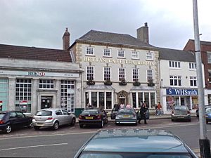
Northallerton's wide High Street has many shops, restaurants, pubs, and cafes. These include local, independent shops like Bettys, Lewis & Cooper, Barkers, and Boyes.
Getting Around Northallerton
Northallerton was built on the Roman road Dere Street. It was a main stopping point for coaches travelling between Scotland and London. There were four coaching inns along the High Street. Coach travel became less popular in the mid-19th century after the railway arrived in 1841.
Two main A roads go through the town. The A684 runs east–west. It connects the A1(M) motorway at Leeming Bar and the A19 at Osmotherley. The A167 runs north–south. It connects the A1(M) at Darlington and the A168 at Topcliffe. The A168 goes from Wetherby through Thirsk to Northallerton.
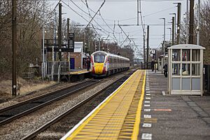
Northallerton railway station is run by TransPennine Express. It is on the East Coast Main Line.
Nearby Leeming Bar is on the historic Wensleydale Railway. This railway goes to Redmire. You can reach it by a Dales & District bus service between the stations.
Northallerton's closest airport is Teesside International Airport. It is about 15 mi (24 km) north of the town, near Darlington.
Sports and Entertainment
Sports in Northallerton
Northallerton Town FC plays in the Northern League. It is the southernmost club in this league. In 1994, the club faced financial trouble but was saved by local business people. Famous football brothers Michael Dawson, Andy Dawson, and Kevin Dawson started their careers at Northallerton Town.
Northallerton Rugby Union Football Club plays in the second division of the Yorkshire League. Their home ground is Brompton Lodge, on the edge of Brompton.
Cricket in Northallerton has been played since 1812. Northallerton Cricket Club played its first recorded match in the early 1860s. The club was one of the six founding teams of the North Yorkshire Cricket League, started in 1893. They later joined the Thirsk & District Senior League in 1911 and won their first title in 1914. The club has won the championship eight more times since then.
In 1949, the club moved to a new ground in Romanby. In 1965, a new pavilion was opened. The club has three teams. The first team plays in division 2 of the North Yorkshire & South Durham Cricket League. The second team plays in division 4. The third team plays in the Darlington and District Cricket League.
The pool at Northallerton Leisure Centre is owned by North Yorkshire Council. It is home to Northallerton Amateur Swimming Club. This club started in 1961. It competes in the Moors League against other clubs in the region.
Entertainment in Northallerton
The Lyric cinema on the High Street opened in October 1939. It could seat 1,000 people and was also used as a theatre. It closed in June 1995. The building was bought by the New Life Baptist Church and became a place of worship.
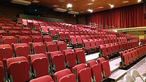
The Forum is an arts and community centre. It hosts theatre shows, films, concerts, and live broadcasts from other theatres. It used to be called Hambleton Forum and was owned by Hambleton District Council. In 2012, the council gave ownership to a charity, and it was renamed Northallerton Forum.
An Everyman Cinema opened in May 2023. It is part of the Treadmills development on the site of the old prison.
Education and Public Services
Learning in Northallerton
Northallerton has six primary schools: Alvertune, Applegarth, Broomfield, Mill Hill, Oakbridge, and Sacred Heart. Oakbridge is a new school that opened in 2024 with a new housing area. After primary school, children go to Northallerton School. This is a secondary school that also has a sixth form for older students. The school also offers adult learning courses.
Public Services
The Yorkshire Ambulance Service NHS Trust provides emergency medical services in Northallerton.
The shared headquarters for North Yorkshire Police and North Yorkshire Fire and Rescue Service is at Alverton Court. The fire station is staffed from 8:00 AM to 6:00 PM daily. Outside these hours, firefighters are on-call.
Yorkshire Water provides mains water and sewage services. Drinking water comes from Bullamoor Reservoir. This reservoir gets water from the River Ure. Until about 2006, Northallerton got its water from Cod Beck Reservoir. Sewage is treated at Northallerton and Romanby Sewage Treatment Works. The treated water then flows into Willow Beck, which is a small river that flows into the River Wiske.
Notable People from Northallerton
See also
 In Spanish: Northallerton para niños
 | George Robert Carruthers |
 | Patricia Bath |
 | Jan Ernst Matzeliger |
 | Alexander Miles |


