Vale of Mowbray facts for kids
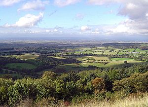
The Vale of Mowbray is a wide, flat area of land in North Yorkshire, England. It sits between two hilly regions: the North York Moors and Hambleton Hills to the east, and the Yorkshire Dales to the west. To the north, it connects with the lowlands of Cleveland. In the south, it joins the larger Vale of York.
This area is known for its gently rolling landscape and winding rivers. The land is very good for farming, with lots of fields for crops and grass. You can still find small areas of woodland too. The roads here often have low hedges and wide grassy edges. Villages in the Vale of Mowbray often stretch out along the main roads, with houses usually built from brick and having distinctive pantile roofs.
Contents
What is the Vale of Mowbray?
Where did the name "Mowbray" come from?
The Vale of Mowbray gets its name from a powerful family. After the Norman Conquest in 1066, William the Conqueror gave this land to Robert de Mowbray in 1086. His family had a strong castle in Thirsk, which is a town in the Vale.
What are the boundaries of the Vale?
Natural England, an organization that protects nature, describes the Vale's borders. To the east, it reaches the edge of the North York Moors. To the west, it follows the A1(M) motorway from Scotch Corner southwards. In the south, the boundary is roughly a line from Dishforth to Thirsk.
What can you find in the Vale of Mowbray?
Towns and villages in the Vale
The Vale of Mowbray is home to several towns and villages. These include:
- Bedale
- Brompton
- Catterick
- Northallerton
- Romanby
- Scorton
- Theakston
- Thirsk
Major roads that cross the Vale
Several important roads run through the Vale, connecting different areas:
- A1 (North-South)
- A19 (North-South)
- A167 (North-South)
- A684 (East-West)
- A172 (North-South)
Railways in the area
Trains also travel through the Vale of Mowbray. Key railway lines include:
- East Coast Main Line (a major route for passenger and freight trains)
- Northallerton–Eaglescliffe line
- Northallerton West–Redmire (a heritage railway, open for 22 miles)
Some older railway lines in the area are now closed, such as the Eryholme–Richmond branch line and the Leeds–Northallerton railway.
Rivers that flow through the Vale
The Vale of Mowbray has several rivers that wind through its landscape:
 | Laphonza Butler |
 | Daisy Bates |
 | Elizabeth Piper Ensley |


