Myton-on-Swale facts for kids
Quick facts for kids Myton-on-Swale |
|
|---|---|
 Myton-on-Swale |
|
| Population | 152 |
| OS grid reference | SE439666 |
| Civil parish |
|
| Unitary authority |
|
| Ceremonial county | |
| Region | |
| Country | England |
| Sovereign state | United Kingdom |
| Post town | YORK |
| Postcode district | YO61 |
| Police | North Yorkshire |
| Fire | North Yorkshire |
| Ambulance | Yorkshire |
| EU Parliament | Yorkshire and the Humber |
| UK Parliament |
|
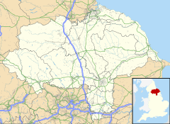
Myton-on-Swale is a small village in North Yorkshire, England. It is located about 3 miles (5 km) east of Boroughbridge. The village sits right next to the River Swale.
Contents
A Look at History
Myton-on-Swale is an old village. It was even mentioned in the Domesday Book. This was a huge survey of England made in 1086. Back then, it was called Mitune.
A very important event happened near the village. This was the Battle of Myton on September 20, 1319. It was fought between local people from Yorkshire and Scottish raiders. The Yorkshiremen were led by William Melton, who was the Archbishop of York. The Scots were led by James Douglas and Thomas Randolph. Many local people were defeated and sadly, many drowned in the River Swale.
How the Village is Governed
Myton-on-Swale is part of the Thirsk and Malton Parliamentary constituency. This means people in the village vote for a Member of Parliament (MP) to represent them in the UK Parliament. The village is also part of the Helperby ward. It is in the Easingwold electoral division of North Yorkshire Council.
Where Myton-on-Swale Is
Myton-on-Swale is located on the south bank of the River Swale. This is close to where the River Swale meets the River Ure.
Here are some nearby places:
- Lower Dunsforth is about 1 mile (1.6 km) to the south.
- Tholthorpe is about 2.25 miles (3.6 km) to the east.
- Aldborough is about 2 miles (3.2 km) to the west.
- Helperby is about 2.125 miles (3.4 km) to the north.
In 2001, about 154 people lived in Myton-on-Swale. Most of them were over sixteen years old. There were 62 homes in the village.
The Village Church
The village has a church called St Mary's Church. It was built in the 1200s. It has been repaired and updated several times since then. The church is a Grade II* listed building. This means it is a very important historical building.
Famous People from Myton-on-Swale
The Stapylton family has lived at Myton Hall for a long time, since the 1600s. Some important members of this family include:
- Sir Bryan Stapylton (1657–1727): He was a Member of Parliament (MP) for different areas. He also served as the Sheriff of Yorkshire.
- Sir John Stapylton (1683–1733): He was also an MP for Boroughbridge.
The village was also home to Sir Ken Morrison (1931–2017). He was the head of Wm Morrison Supermarkets plc, a big supermarket company.
Important Buildings
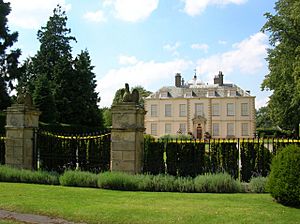
Myton Hall is a very old and important building. It is a Grade I Listed Building. This means it is a building of exceptional historical interest. The Stapylton family lived here for many years.
Near Myton Hall, the gate piers, wall, and railings are also Grade I Listed. This shows how special the whole estate is.
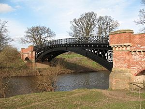
There are two other important buildings in the village that are Grade II Listed. This means they are historically important. One of these is the Myton Bridge. It is an iron bridge built in 1868 by the Stapylton family. It used to be a toll bridge, meaning people had to pay to cross it. It replaced an older ferry and bridge.
 | Isaac Myers |
 | D. Hamilton Jackson |
 | A. Philip Randolph |


