Bedale Beck facts for kids
Quick facts for kids Bedale Beck |
|
|---|---|

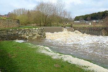
The Harbour at Bedale
|
|
| Other name(s) | Burton Beck Crakehall Beck Leeming Beck Newton Beck |
| Country | England |
| State | North Yorkshire |
| District | Hambleton District |
| Physical characteristics | |
| Length | 25.7 mi (41.4 km) |
| Basin features | |
| River system | River Swale |
The Bedale Beck is a small river, also called a "beck," that flows through a beautiful area of North Yorkshire, England. It starts in the eastern part of Wensleydale and makes its way through several towns. These towns include Crakehall, Bedale, and Leeming. Finally, it joins the larger River Swale between Morton-on-Swale and Gatenby. The Bedale Beck is about 25.7 miles (41 km) long from where it begins to where it ends.
Contents
Where Does Bedale Beck Flow?
The Bedale Beck actually starts as a mix of three smaller streams. These streams are called Bellerby Beck, Burton Beck, and another unnamed one. They all begin high up in the hills north of Leyburn. Bellerby Beck, for example, flows down from the moorland above the village of Bellerby.
The Beck's Journey Through Towns
When these streams meet at Constable Burton, they flow under the A684 road. As the beck continues, it's known by different names. Between Constable Burton and Patrick Brompton, maps show it as Burton Beck, Leeming Beck, and Newton Beck. When it reaches Crakehall, it's also called Crakehall Beck.
The name Bedale Beck officially begins just east of Crakehall. From there, it flows south, passing under the new A684 bypass. It then enters the town of Bedale. In Bedale, the beck forms a natural border between the areas of Aiskew and Bedale.
From Bedale to the River Swale
After Bedale, the beck turns east and then north. It flows under the A6055 road and the busy A1(M) motorway. Then, it changes direction again, heading east along the northern edge of RAF Leeming. Finally, the Bedale Beck meets the River Swale. This meeting point is located between the villages of Morton-on-Swale and Gatenby.
What is the History of Bedale Beck?
The Bedale Beck has been important to local communities for a long time. People used its flowing water to power mills. These mills helped grind corn and do other work.
Water Mills Along the Beck
Records show that at least two water mills were operating near Bedale by the year 1297. The most famous mill is still standing at Crakehall. It was fixed up in the 1980s and again more recently. Today, it still grinds corn on special open days. Both the mills at Aiskew and Crakehall had special channels called "millraces" to direct water to them. Crakehall's millrace is still there and moves water. The mill at Aiskew had closed, but it was reopened in 2010 as a community bakery.
In the 1700s, people tried to make the Bedale Beck wide enough for boats. The idea was to connect Bedale to the River Swale by water. However, this plan didn't work out because there wasn't enough money. Later, in 1855, a railway line was built, which made the idea of a canal less important.
Even today, the area below a small waterfall (weir) and a water gate (sluice gate) is still called 'The Harbour'. This shows how important the old plan was. The larger plan was to make the River Swale navigable all the way from the River Ure up to Bedale. This involved building a lock, which is like a water elevator for boats, near Leeming village. This lock was known as Leeming Lock. It stayed there until it was destroyed during the Second World War. No one knows if it was blown up on purpose or by accident. This big plan also meant changing the path of a stream that flows past Floodbridge Farm. Now, it joins Bedale Beck further downstream than it used to.
Flooding Problems
Sometimes, the Bedale Beck can flood, causing problems for the area. In 1900, floodwaters washed away the ground under the railway tracks west of Bedale. This caused a train to go off the tracks, and sadly, the train's fireman died.
What About the Environment of Bedale Beck?
Experts have looked at Bedale Beck and other streams that flow into the River Swale. They found that the beck's environment is not in the best condition.
Ecological Concerns
There is too much sediment, like dirt and sand, getting into the water. This sediment can harm the homes of fish and other water creatures. It also increases levels of phosphates, which are chemicals that can cause problems in the water. All of this can also make flooding worse.
Areas Prone to Flooding
The towns of Bedale and Leeming are especially likely to flood from the beck. This is because the land between these two towns is very flat and low-lying. This area has even been called a 'level floodplain' because it's so flat compared to the rest of the beck's path.
 | Ernest Everett Just |
 | Mary Jackson |
 | Emmett Chappelle |
 | Marie Maynard Daly |

