
Rawcliffe, East Riding of Yorkshire facts for kids
Quick facts for kids Rawcliffe |
|
|---|---|
 The Green, Rawcliffe |
|

Rawcliffe
|
|
| Population | 2,379 (2011 census) |
| OS grid reference | SE684230 |
| Civil parish |
|
| Unitary authority | |
| Ceremonial county | |
| Region | |
| Country | England |
| Sovereign state | United Kingdom |
| Post town | GOOLE |
| Postcode district | DN14 |
| Dialling code | 01405 |
| Police | Humberside |
| Fire | Humberside |
| Ambulance | Yorkshire |
| EU Parliament | Yorkshire and the Humber |
| UK Parliament |
|
Rawcliffe is a lovely village located in the East Riding of Yorkshire, England. It's sometimes called Rawcliffe in Snaith to tell it apart from other places. This village is close to the border with North Yorkshire.
Rawcliffe is about 4 kilometers (2.5 miles) west of a town called Goole. It's also about 27 kilometers (17 miles) south of the historic city of York. The village sits right next to the River Aire. You can find it just north of the M62 motorway and along the A614 road.
Long ago, in the 1730s, Rawcliffe and a nearby place called Airmyn were known for an old farming method. This method was called "warping." It involved using river water to make farmland better.
Contents
Exploring Rawcliffe Village

Rawcliffe is more than just one village! It's part of a larger area called a civil parish. This parish includes the main village of Rawcliffe and a smaller settlement. This smaller place is a hamlet called Rawcliffe Bridge. It's located just to the south-east of the main village.
How Many People Live Here?
Every few years, the United Kingdom counts its population. This is called a census. The 2011 UK census showed that 2,379 people lived in Rawcliffe parish. This was an increase from the 2001 UK census, which counted 2,087 people. This means more families chose to live in Rawcliffe!
Getting Around by Train
Rawcliffe has its own railway station. This station is on the Pontefract Line. This railway line was originally part of a route built by the Lancashire and Yorkshire Railway. It helped connect places like Rawcliffe to nearby towns such as Goole.
A Look at Local History
For many years, Rawcliffe was part of different local government areas. From 1894 to 1974, it was in the Goole Rural District. This was part of the West Riding of Yorkshire. Then, from 1974 to 1996, it became part of the Boothferry district. This area was part of a larger county called Humberside. Today, Rawcliffe is part of the East Riding of Yorkshire.
St James' Church
The main church in Rawcliffe is called St James' Church. It's a very old and important building. In 1986, it was given a special status. It was named a Grade II listed building. This means it's a historic building that needs to be protected.
Sugar Mill Ponds Nature Reserve
Near Rawcliffe Bridge, there's a special place for nature lovers. It's called Sugar Mill Ponds. This area used to be the site of an old sugar factory. Now, it's a 20 acres (8 ha) Local Nature Reserve. This means it's a protected area where plants and animals can thrive. It's a great place to explore nature!
Images for kids
-
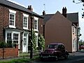
A house on The Green, a lovely open space in Rawcliffe.
-
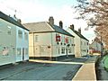
A sign for Jemmy Hirst at the Rose and Crown pub.
-
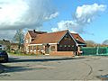
The Royal Oak, another local pub in Rawcliffe.
-
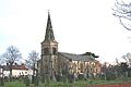
St James' Church, a historic building in Rawcliffe.


See also
 In Spanish: Rawcliffe para niños
