
Bradford Beck facts for kids
Quick facts for kids Bradford Beck |
|
|---|---|

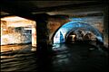
The subterranean cathedral arches of Bradford
|
|
| Other name(s) | 'T' Mucky Beck' |
| Country | England |
| City | Bradford, West Yorkshire |
| Physical characteristics | |
| Main source | Clayton Beck, Cemetery Road, Lidget Green 120 metres (390 ft) 53°47′42″N 1°47′31″W / 53.79513°N 1.79189°W |
| River mouth | Dockfield, Shipley, West Yorkshire 70 metres (230 ft) 53°50′15″N 1°46′20″W / 53.83744°N 1.77212°W |
| Length | 6.8 miles (11 km) |
| Basin features | |
| River system | River Aire |
| Basin size | 58 square kilometres (22 sq mi) |
| Tributaries |
|
The Bradford Beck is a river that flows through Bradford, West Yorkshire, England. It eventually joins the River Aire in Shipley. A long time ago, the beck was known as the filthiest river in England because of all the pollution.
As the river reaches Bradford city centre, it goes underground. This happened because buildings were constructed over it in the 1800s. The name Bradford itself comes from a crossing point on the beck called the Broad Ford. This crossing was near where Church Street is today.
The Bradford Beck is actually made up of many smaller streams that join together. Some of these are Pinch Beck, Clayton Beck, Bowling Beck, and Eastbrook.
Contents
History of Bradford Beck
In Anglo-Saxon times, the town of Bradford grew up around where several streams met. This was also the location of important bridges and the local church, which later became Bradford Cathedral. In the Middle Ages, water from one of these streams was used to power mills. These mills were in the Sunbridge and Thornton Road areas.
A long time ago, a ducking stool was kept on the beck. This was used to punish people who caused trouble. When the Bradford Arm of the Leeds and Liverpool Canal opened, the ducking stool was moved there.
Water from Bradford Beck was used to fill the canal. However, the beck was very polluted in the 1800s. People described it as "coal-black" and "foul-smelling." This made the Bradford Canal very dirty.
Because of many complaints, especially from people living near the River Aire, the Bradford Corporation had to do something. They built sewage treatment plants to clean the water. The first was at Frizinghall, and later another was opened at Esholt.
In the early 1990s, a large tunnel was built to help prevent floods. This tunnel helps to control the water flow of the beck.
Even though sewage is now sent through pipes, the beck still faces pollution. This happens because of special pipes called combined sewer overflows (CSOs) and other wrongly connected drains. In 2018, the beck even turned yellow because of waste from some local restaurants. This waste entered the beck through misconnected pipes.
Since 2013, a group called the Friends of Bradford's Becks has been working to clean up the river. The water is much cleaner now. However, because the beck flows very fast through its underground concrete channels, it's hard for much wildlife to live there. The Friends group wants to make changes to the open parts of the beck to slow the water down and help nature return.
Where the Beck Flows
The Environment Agency says that the area of land that drains into Bradford Beck is about 58 square kilometres (22 square miles). The beck is divided into two parts. The upper part is called Clayton Beck. The main part, Bradford Beck, starts where Clayton Beck goes under Cemetery Road in Bradford. From there to the River Aire in Shipley, it is about 11 kilometres (7 miles) long.
As the beck flows underground through Bradford city centre, special plaques are being placed on the ground to mark its path. The first plaques were put in place in 2015 near The Broadway shopping centre.
The beck flows east from the Bradford moorland. Near the cathedral, it meets Bowling Beck and Eastbrook. Then it turns sharply north.
After the city centre, some parts of the beck are open to the sky, but it is mostly covered until Queen's Road. From Queen's Road to Shipley, the beck is mostly open. There used to be signs warning people about contaminated water. The Friends of Bradford's Becks have changed these signs to show that the water quality is much better now. The beck flows under railway lines and a main road before joining the River Aire in Shipley.
Nature and the Environment
In 2009, the Environment Agency said the beck had good chemical quality but poor ecological quality. This means the water itself was okay, but it wasn't good for plants and animals. A study in 2012 found high levels of chemicals like phosphates, ammonia, and metals in the water. These often come from combined sewer overflows (CSOs), which let pollution into the water during heavy rain.
A study in 2012 by the Wild Trout Trust found that the beck was not good for fish like trout. There are too many weirs (small dams) and other things that stop fish from swimming upstream.
In 2015, a special test was done using tampons to find pollution. Tampons don't have special brighteners in them. So, if tampons placed in the beck absorbed brighteners, it meant household pollution was entering the water. This helped officials find where the pollution was coming from.
In April 2019, an investigation was reopened into a company that had caused pollution in the beck in 2018. The Friends of Bradford's Becks felt that the punishment for the company was not enough. This pollution incident was said to have turned the water black and harmed wildlife.
Exploring the Beck
You cannot use boats on the Bradford Beck. However, because much of it is underground, it attracts people who like to explore hidden tunnels and underground places. The beck has even been featured in a National Geographic article about rivers that have been forced underground around the world.
Images for kids
-
The subterranean cathedral arches of Bradford
