
River Foss facts for kids
Quick facts for kids River Foss |
|
|---|---|

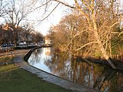
The River Foss at York, looking upstream. The bridge is the Foss Bridge (1811–12), which links the streets of Fossgate and Walmgate.
|
|
| Country | England |
| Physical characteristics | |
| Main source | Near Oulston Reservoir, Yearsley 160 m (520 ft) 54°09′38″N 1°07′54″W / 54.160556°N 1.131667°W |
| River mouth | River Ouse, York 12 m (39 ft) 53°57′05″N 1°04′42″W / 53.951389°N 1.078333°W |
| Basin features | |
| Basin size | 118 square kilometres (46 sq mi) |
The River Foss is a river in North Yorkshire, England. It's a smaller river that flows into the River Ouse. The Foss starts in the Foss Crooks Woods, near Oulston Reservoir and the village of Yearsley. It then flows south through the Vale of York until it meets the Ouse right in the middle of York.
The name "Foss" probably comes from the Latin word Fossa, which means "ditch". However, since Norwegian and Danish people settled in the York area long ago, the name could also come from the Old Norse word Fos, meaning "waterfall". The river was once dammed, which created a waterfall, so this might be how it got its name.
The River Foss is managed by a group called the Foss Internal drainage board (IDB). They look after the river's drainage area, which covers a large part of the land from Crayke to York. The river's water level at the Foss Barrier usually stays between 5.05 meters and 7.90 meters. The highest it has ever been was 10.20 meters.
Contents
Where Does the River Foss Flow?
The River Foss begins as a spring in the Howardian Hills. This spring is right next to, and flows into, Oulston Reservoir, which is near Newburgh Priory. From there, the river travels about 19.5 miles (31 km) until it reaches the Blue Bridge in York, where it joins the River Ouse.
For some of its journey, the Foss flows near the B1363 road between Brandsby and Stillington. The river winds in wide curves, mostly flowing south towards York. Today, you can travel by boat on about 1.5 miles (2 km) of the river upstream from Castle Mills Lock. However, bridges like the ones at Peasholme Green and Foss Bank mean there's only about 2.4 meters of space above the water for boats to pass under.
How the River Foss Has Been Changed

A special structure called the Foss Barrier was built across the river near where it meets the Ouse, at Castle Mills. This barrier is very important because when the River Ouse floods, the barrier closes. This stops the Ouse's floodwater from pushing the Foss's water back upstream and causing floods in York.
When the Ouse river level gets high, staff at the barrier are warned. If the Ouse reaches a certain level, the barrier is lowered. Before it closes completely, pumps run for a few minutes to clear any mud or rubbish from the riverbed, making sure the barrier can seal tightly. It only takes four minutes for the barrier to close.

To prevent the River Foss from overflowing its banks when the barrier is closed, eight powerful pumps move water from the Foss around the barrier and into the Ouse. These pumps can move 30 tonnes of water every second! This keeps the water level behind the barrier at a safe height. Once the water levels on both sides of the barrier are equal, the barrier can be opened again.
There's also a lock called Castle Mills Lock, which is 34 meters long and 6 meters wide. Boats can moor (park) in the lock basin on the Ouse side, but you can't stay overnight on the Foss side.
The History of the River Foss
In 1069, William the Conqueror built a dam on the Foss, just south of York Castle. This created a moat (a water-filled ditch) around the castle. The dam also caused the river to flood further upstream, creating a large lake known as the "King's Pool" or "King's Fish Pond." This lake was about 100 acres big and provided fish for the markets in York. Fishing was allowed with a special permit, except for the King's own men.
The King's Pool was an important part of York's defenses during the Middle Ages. The marshy area was almost impossible to cross, which is why there wasn't a city wall built between Layerthorpe Postern and the Red Tower.
Over time, in the 17th century, the King's Pool and the Foss started to get shallower. Mud from upstream collected in the pool, and not enough water flowed down to wash it away. Even though the main channel of the Foss was deepened in 1608, the lake eventually became too shallow to be a good defense. In 1644, during the English Civil War, the lake was so shallow that Parliamentarian forces even thought about walking across it to try and break the Siege of York.
In the 18th century, the water level was so low that marshy islands formed, which is why the area is now called Foss Islands. People also started using the river as a rubbish dump, which became a health problem. To fix this, new laws were passed in 1793 and 1801 to make the Foss navigable (meaning boats could use it) and this also led to the end of the King's Pool. The Foss Navigation Company made the river into a canal from 1778, allowing boats to travel as far as Sheriff Hutton.
Later, in 1853, the York Corporation (the local government) bought the River Foss from the Foss Navigation Company. In 1859, another law was passed, and the river above Yearsley Bridge was no longer used for boats.
Fun Things to Do Near the Foss
Long ago, the River Foss was important for trade. Roman jetties (small docks), wharves (places for boats to load and unload), and warehouses have been found along its banks. This shows that moving goods by water was a big part of the city's early history.
Today, the Foss is mostly used for fun activities. Several long-distance walking paths cross its route. The Foss Walk follows much of the river from the Blue Bridge all the way to Oulston Reservoir and on to Easingwold, which is a distance of 28 miles (45 km). Other paths like the Howardian Way, Ebor Way, and Centenary Way also follow parts of the Foss.
Animals in the River Foss
Many different types of fish live in the River Foss. You might find Pike, Dace, Chub, Gudgeon, Perch, and Roach. More recently, a type of fish called Barbel has also been introduced into the river.
The River Foss Barrier: Stopping Floods
The city of York sometimes experiences flooding from the River Ouse. The River Foss Barrier is a key part of a plan to help prevent this.
The River Foss flows into the River Ouse near York Castle. In the past, especially in 1947, 1978, 1982, and at the end of 2015, major floods happened, leaving many areas underwater.
After the 1982 flood, a study showed that the flood levels in the Foss were directly linked to the levels in the River Ouse. This led to the idea of building a barrier to stop the Ouse's water from flowing back into the River Foss. In 2016, money was set aside to improve the barrier's pumps, making them even better at moving water and preventing floods.
Rivers and Places Connected to the Foss
Tributaries: Smaller Rivers Joining the Foss
Many small streams flow into the River Foss, especially north of Strensall. The most important ones are:
- Eller's Beck, northwest of Crayke.
- Brandsby Beck, southwest of Crayke.
- Farlington Beck, south of Farlington.
- Whitecarr Beck, near Sherriff Hutton Bridge.
- Howl Beck, near Sherriff Hutton Bridge.
- Black Dike near Strensall.
Settlements: Towns and Villages Along the Foss
Moving from north to south, towards where the Foss meets the Ouse, you'll find these places:
Bridges Over the Foss
Here are some of the bridges that cross the River Foss, listed from north to south:
|
|
Gallery
- Along the River Foss: Source to Confluence
-
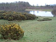
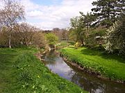
Oulston Reservoir near source of River Foss
54°09′48″N 1°08′10″W / 54.163205°N 1.136180°W -
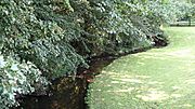
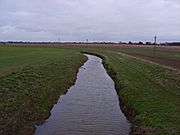
River Foss near Crayke 2 miles from its source
54°8′16.55″N 1°8′1.12″W / 54.1379306°N 1.1336444°W -
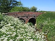
Bridge over the River Foss near Farlington
54°05′11″N 1°04′31″W / 54.086257°N 1.075253°W -
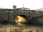
Bridge over River Foss in Strensall on road heading to Sherriff Hutton
54°02′27″N 1°02′03″W / 54.040824°N 1.034267°W -
River Foss in Strensall as seen from the Post Office
54°02′27″N 1°02′07″W / 54.040923°N 1.035334°W -
River Foss viewed from Towthorpe Bridge towards Strensall
54°01′30″N 1°03′12″W / 54.024888°N 1.053412°W -
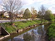
River Foss New Earswick
53°58′59″N 1°04′44″W / 53.983022°N 1.078913°W -
River Foss Huntington Road, York
53°58′58″N 1°03′49″W / 53.982905°N 1.063667°W -
River Foss from Monk Bridge
53°57′57″N 1°04′23″W / 53.965901°N 1.073194°W -
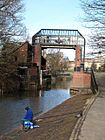
Pedestrian bridge from the west, looking downstream near DEFRA buildings
53°57′37″N 1°04′22″W / 53.960272°N 1.072903°W -
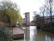
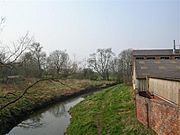
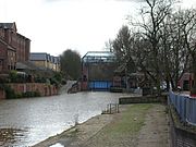
Looking upstream from Foss Bridge to Rowntree Wharf, with Wormald's Cut to the right.
53°57′29″N 1°04′38″W / 53.957975°N 1.07725°W -
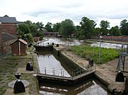
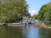
Castle Mills Lock and Basin, near the Foss Barrier and the confluence with River Ouse
53°57′15″N 1°04′41″W / 53.954078°N 1.077944°W -
The River Foss Barrier (closed), viewed from the north (Castle Mills Basin)
53°57′11″N 1°04′44″W / 53.95295°N 1.078769°W -
The River Foss Barrier (open), viewed from the south
53°57′08″N 1°04′42″W / 53.952342°N 1.078394°W -
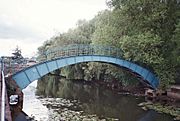
View from the River Ouse of the confluence and the "Blue Bridge"


.jpg)


See also
 In Spanish: Río Foss para niños
