
River Nidd facts for kids
Quick facts for kids River Nidd |
|
|---|---|

|
|


|
|
| Country | England |
| Physical characteristics | |
| Main source | Nidd Head Spring, 1.3 km north of the summit of Great Whernside 595 metres (1,952 ft) |
| River mouth | River Ouse, Nun Monkton 13 metres (43 ft) 54°0′51″N 1°13′8″W / 54.01417°N 1.21889°W |
| Length | 94.45 kilometres (58.69 mi) |
| Basin features | |
| River system | Swale–Ouse |
| Basin size | 516 square kilometres (199 sq mi) |
The River Nidd is a fascinating river in North Yorkshire, England. It's like a long, winding journey that starts high up in the hills and eventually joins a bigger river called the River Ouse. Imagine a tiny spring on the side of a mountain, Great Whernside, that's where the Nidd begins!
As the river flows, it passes through a beautiful area called Nidderdale. This area is so special that it was named an "Area of Outstanding Natural Beauty" in 1994. Along its path, the Nidd helps fill three large reservoirs: Angram Reservoir, Scar House Reservoir, and Gouthwaite Reservoir. These reservoirs are important for providing water and are also popular places for people to visit.
The Yorkshire Dales Rivers Trust works hard to keep the River Nidd healthy and clean, from its very beginning all the way to where it meets the sea.
Contents
The River Nidd's Journey
The River Nidd starts its adventure at Nidd Head Spring, high up on the slopes of Great Whernside in the Yorkshire Dales. It flows east and soon reaches two large reservoirs, Angram and Scar House. After these, it turns south.
One of the most amazing things about the Nidd is that it sometimes disappears! In normal weather, the river flows into a giant hole in the ground called Manchester Hole. If there's a lot of rain and the Scar House reservoir overflows, the water flows past Manchester Hole to another sinkhole called Goyden Pot. During very big floods, the river can even flow above ground all the way down the valley. The water that goes underground through these caves eventually comes back out at a place called Nidd Head, near the village of Lofthouse.
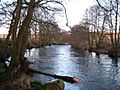
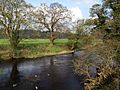
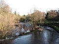
After Lofthouse, other small streams join the Nidd, making it bigger. It then flows south-east towards Ramsgill and into Gouthwaite Reservoir. The river continues its journey, passing through towns like Pateley Bridge, Glasshouses, and Summerbridge. It then turns south again, flowing past Dacre Banks and Darley.
The Nidd then makes its way east to Birstwith and then south-east to Hampsthwaite. It takes some big turns, flowing north, east, south, and east again, before entering a dramatic area known as Nidd Gorge.
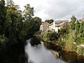
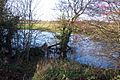
Below the gorge, the river winds through the town of Knaresborough. It then flows through flatter land, passing near Little Ribston and crossing under the major A1 and A1(M) motorways near Cowthorpe. The Nidd keeps winding north-easterly towards Moor Monkton, finally joining the mighty River Ouse at Nun Monkton.
Important Reservoirs Along the Nidd
The River Nidd is home to three important reservoirs. The two furthest north were built a long time ago, in the early 1900s. They were created to supply drinking water to the city of Bradford. Today, Yorkshire Water looks after them.
Angram Reservoir: A Hidden Village
Angram Reservoir gets its name from a village that was once there, called Angram. This village was covered by water when the reservoir was built! It was finished in 1919. The dam is about 61 meters (200 feet) high. The reservoir covers an area of 34 hectares (about 84 acres) and holds a huge amount of water.
Scar House Reservoir: A Workers' Village
When Scar House Reservoir was being built, a temporary village was created nearby for all the workers. You can still see some parts of this old village today! The old Village Hall was even moved to a different town, Darley, where it's still used. The dam at Scar House was completed in 1936. It's even taller than Angram's dam, at 71 meters (233 feet) high. This reservoir is larger, covering 70 hectares (about 173 acres), and gets most of its water from Angram Reservoir.
Gouthwaite Reservoir: A Special Nature Spot
Gouthwaite Reservoir is a very special place for nature. It's called a "Site for Special Scientific Interest" because it's home to important plants and animals. This reservoir also helps control the river's flow, releasing water to keep the river healthy downstream. It covers a large area of about 312 acres.
Sometimes, if there's a lot of rain, the Nidd can overflow its banks and even flood the Nidderdale Caves. When this happens, the river flows over the normally dry riverbed past Lofthouse and into Gouthwaite Reservoir.
How the Land Shapes the River Nidd
The area where the River Nidd begins is mostly open moorland. The type of rock and soil here really affects how the river flows. The upper part of the valley has a lot of "millstone grit" rock and deposits left by ancient glaciers. The soil on top of this rock can get very wet because water doesn't drain through it easily. It's made of loamy soil over clay, with peat on top.
Near Lofthouse, you can find a different type of rock called "Upper Yoredale limestone." This rock is more porous, meaning water can seep through it. This is why the amazing Nidderdale Caves were formed, and it's where the river sometimes flows underground!
Further down the valley, where the land is flatter, the ground is made of "Magnesian Limestone" over layers of river deposits. Here, the soil can be a mix of slow-draining and well-drained loamy soil over clay.
As the river carves its way through the Nidd Gorge, you can see very old rocks from the Carboniferous and Upper Permian periods. These rocks tell a story of Earth's ancient past!
What's in a Name? The Meaning of "Nidd"
The exact meaning of the name "Nidd" is a bit of a mystery! Experts think it might come from a very old language called Proto-Celtic, or even an older language that was spoken before Celtic. Many rivers in Europe have names that come from these ancient languages.
One idea is that "Nidd" means something like "bright," "brilliant," or "shining." Imagine the river sparkling in the sunlight – that would be a perfect name! Another idea connects it to an even older word that simply meant "river."
It's interesting to know that the River Nidd might share its name origin with other rivers and towns across Europe, like the River Neath in Wales, or rivers in Belgium, France, Germany, and Poland. It shows how languages and names can travel far over time!
Fun Things to Do Along the River Nidd
The River Nidd valley is a great place for fun and learning!
- Nidderdale Museum: In the town of Pateley Bridge, you can visit the Nidderdale Museum. It's a fantastic place to learn about the history of the area, including how people used to farm, what jobs they did, and how they traveled.
- Knaresborough Castle: Further down the river, you'll find the historic town of Knaresborough. Here, you can explore the ruins of Knaresborough Castle and visit the Knaresborough Museum to discover more about the town's past.
- Walking and Exploring: If you love walking, the Nidd valley is perfect! There are many marked walking paths. One famous route is the Nidderdale Way, a long circular walk that's about 55 miles (88 kilometers) long. It's a wonderful way to see the beautiful scenery and enjoy nature.
Images for kids
-
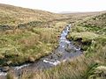
River Nidd less than 0.6 miles (1 km) from the source
-
River Nidd at Lofthouse
-
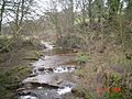
River Nidd near West House Farm
-

River Nidd near Pateley Bridge
-
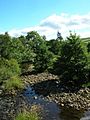
River Nidd at Glasshouses
-
River Nidd below Dacre
-
River Nidd between Birstwith and Hampsthwaite
-
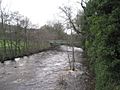
River Nidd from Killinghall Bridge
-
The River Nidd at Knaresborough
-
River Nidd near Tockwith Road


