Skipsea Castle facts for kids
Quick facts for kids Skipsea Castle |
|
|---|---|
| Skipsea, East Riding of Yorkshire, England | |
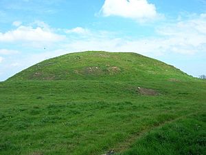
The castle's motte
|
|
| Coordinates | 53°58′43″N 0°13′47″W / 53.978668°N 0.229589°W |
| Site information | |
| Owner | English Heritage |
| Open to the public |
Yes |
| Condition | Earthworks only remain |
| Site history | |
| Built | c. 1086 |
| Built by | Drogo de la Beuvrière |
| Events | Rebellion of William de Forz |
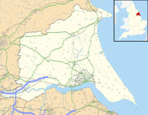
Skipsea Castle was a motte and bailey castle built by the Normans in England. It stands near the village of Skipsea, in the East Riding of Yorkshire. Drogo de la Beuvrière built it around 1086. The castle was important for keeping the newly conquered land safe. It also helped protect against possible attacks from the Danes. Plus, it controlled a key trade route that led to the North Sea.
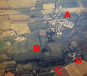
The castle had two main parts: a motte (a large mound) and a bailey (a walled courtyard). These parts were separated by Skipsea Mere, an artificial lake. This lake was connected to the sea during the medieval period. A channel allowed boats to travel to and from the sea. A village grew up next to the castle's church. Later, a fortified town called Skipsea Brough was built nearby around 1160. This town was meant to help with trade.
In 1221, the castle's owner, William de Forz, rebelled against King Henry III. The King's army captured the castle. Henry III then ordered it to be destroyed. By the late 1300s, the castle ruins were not very useful. The town of Skipsea Brough also did not grow as planned. Today, English Heritage looks after the castle. It is open for visitors to explore the remaining earthworks.
Contents
History of Skipsea Castle
Early Beginnings
The large mound where Skipsea Castle was built was not new. It was actually a much older structure from the Iron Age. This early mound was similar to Silbury Hill in Wiltshire. In 2016, scientists took samples from inside the mound. They found seeds and other old plant material. These findings showed that the mound was built around 400 BC.
Norman Times: 11th and 12th Centuries
Skipsea Castle was built around 1086. It was built by Drogo de la Beuvrière, a soldier from Flanders. He became the first Lord of Holderness. This happened after the Norman conquest of England and the Harrying of the North. The area was on the edge of Norman control. The castle was meant to protect central Yorkshire from possible Danish raids. These raids could come across the North Sea.
Skipsea was the main center for Drogo's huge lands. His lands stretched from the Humber to Bridlington. It was also his main home. The name "Skipsea" comes from an old Scandinavian word. It means a lake that ships could sail on. In medieval times, the castle site was an inland harbour. It had a channel that connected it to the North Sea. Today, the sea is only about 2 kilometers away. The area around the castle was like an "island" back then. This was because of the surrounding estuary and flood plains.
The castle's location was very important. It was on the main trade route through the marshes. It could also be reached by sea. So, the castle had two jobs: to control the new Norman lands and to manage trade.
The castle was a motte and bailey design. A dam was likely built to create an artificial lake. This lake was called Skipsea Mere. It was connected to the channel leading to the sea. The castle had its own private harbour. It probably also had a boat yard and a place to catch fresh-water fish. By the late 1000s, a church was built east of the castle. The village of Skipsea soon grew up next to the church.
Drogo placed ten knights on lands near the castle. This was part of a system called castle-guard. The knights helped guard the castle in exchange for their land. One of them might have built a smaller fort nearby at Aldborough.
After his wife died under suspicious circumstances, Drogo left England. William the Conqueror then gave the castle to Odo. In 1096, it went to Arnulf de Montgomery. But it returned to Odo's family in 1102. They held it until 1221. Trade was good at first. Because of this, William le Gros built the fortified town of Skipsea Brough. It was just south of the castle, probably around 1160. The town was meant to bring money to the earls. It also helped protect the castle on its most open side. The castle-guard system ended. The surrounding lands then paid their rents in money instead.
Later Years: 13th and 14th Centuries
After about 1200, the castle became less important. Its location was not ideal. Also, the threat of Danish raids was gone. So, a nearby manor at Burstwick became the new main center. In January 1220, William de Forz rebelled against King Henry III. Part of their disagreement was about land that Henry had taken. William had also disagreed with Henry's rules for years.
William was quickly removed from the church. King Henry moved fast to stop the rebellion. Barons in the north were told to attack William's castles, including Skipsea. William soon gave up to the King and was forgiven. After the rebellion, Henry ordered Skipsea Castle to be destroyed. We are not sure how much of this order was actually carried out.
William passed the castle to his son, also named William. But when his son's widow, Isabella, died, the castle went to the Crown in 1293.
Skipsea Mere was drained in the late 1300s. By 1397, the castle was considered worthless. The land around it was used for grazing animals. The counts of Aumale used a manor house at nearby Cleeton when they visited. The town of Skipsea Brough also did not do well as a trading place. There were only three people paying rent in the town in 1260. By the late 1300s, the town was mostly empty. In 1377, only 95 people were counted for the poll tax in both Skipsea and Skipsea Brough.
Modern Times: 15th to 21st Centuries
More of the mere was drained around 1720. Its land was then reclaimed for farming. The ground stayed marshy and sometimes flooded even in the early 1900s. In 1911, the castle was put under the care of the government. It is now managed by English Heritage. Archaeologists studied the site in 1987, 1988, 1992, and 2001.
The castle is a Scheduled Monument under UK law. This means it is protected. The remaining earthworks are generally well preserved. However, between 2010 and 2014, English Heritage worried about its condition. They were concerned that drainage was drying out the land. This could affect the castle's earthworks. Only a few buildings remain in the planned town of Skipsea Brough.
Castle Design and Surroundings
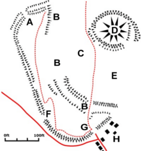
Skipsea Castle was built as a motte and bailey castle. The two main parts were separated by Skipsea Mere. The lake surrounded the motte. The south-east part of the lake was cut off by two raised paths. These paths were to the south and east of the motte. Eels were caught in the lake in the 1200s. The south-east corner might have been a fresh-water fishing area.
A curved channel flowed along the south-west side of the motte. It was about 25 by 200 meters in size. This channel eventually led to the North Sea. It allowed boats to reach docks inside the bailey. At the eastern end of the channel, there might have been a boat yard. Some archaeologists think there might have been another inland harbour west of the bailey. However, experts do not all agree on this.
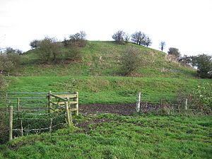
The motte was made from sand and gravel. It was built on a natural hill, which made it look extra large. It is 100 meters wide and 11 meters high. The top has about 0.25 acres of space. Around the base, there was a 1.5-meter-high bank. There was also a ditch up to 10 meters wide. When first built, these would have been taller and deeper. There was a timber keep (a strong tower) on the motte. There might have been a stone gatehouse at the south-east corner. This led to a raised path that crossed the mere to connect the motte with the bailey. The eastern path connected the motte with the church in Skipsea village.
The bailey was about 300 by 100 meters. It covered an area of about 8.25 acres. It curved around the west and south sides of the castle. Its earthworks were made from clay. It had a rampart (a defensive wall) up to 4 meters high. This was protected by a 10-meter-wide ditch. The ditch was originally up to 4 meters deep. The main entrance to the bailey was on the south side. It was called Bail Gate and had a gatehouse. There was a smaller entrance on the north side, connected by a path. A break in the earthworks, called Scotch Gap, was made when the castle was destroyed in the 1200s. The bank has also been damaged by drainage work.
 | Mary Eliza Mahoney |
 | Susie King Taylor |
 | Ida Gray |
 | Eliza Ann Grier |


