
Silbury Hill facts for kids
| UNESCO World Heritage Site | |
|---|---|
 |
|
| Location | Avebury, Wiltshire, England |
| Part of | Stonehenge, Avebury and Associated Sites |
| Criteria | Cultural: i, ii, iii |
| Inscription | 1986 (10th Session) |
Silbury Hill is a huge, man-made hill from ancient times. It's located near Avebury in Wiltshire, England. This amazing hill is part of the Stonehenge, Avebury and Associated Sites UNESCO World Heritage Site, which means it's a very important place for everyone to protect.
Standing at about 39.3 meters (129 feet) tall, Silbury Hill is the tallest prehistoric man-made mound in Europe. It's also one of the biggest in the world, similar in size to some of the smaller Egyptian pyramids!
Silbury Hill is part of a group of ancient monuments from the Neolithic period (New Stone Age) around Avebury. These include the Avebury Ring and West Kennet Long Barrow. People still wonder why Silbury Hill was built. Other important Neolithic sites in Wiltshire, like Marden and Stonehenge, might be connected to Avebury and Silbury Hill in some way.
Contents
How Silbury Hill Was Built
Silbury Hill is mostly made of chalk and clay. These materials were dug up from the area around the hill. The mound is about 40 meters (131 feet) high and covers an area of about 2 hectares (5 acres).
The hill was built in several steps between about 2400 and 2300 BC. Building it showed amazing skill and a lot of planning for workers and materials. Experts believe it took 18 million hours of work. This is like 500 people working for 15 years straight! They moved and shaped about 248,000 cubic meters (324,000 cubic yards) of earth. Some archaeologists think that only a very strong leader or group could have managed such a huge project.
The bottom of the hill is round, about 167 meters (548 feet) across. The top is flat and about 30 meters (98 feet) wide. A smaller mound was built first, then made much bigger later. The first parts of the hill were perfectly round. The center of the flat top and the center of the hill's cone shape are almost exactly in line. It seems the top might have been rounded at first, but it was flattened in the Middle Ages. This was possibly to build something for defense.
The first clear signs of building, from around 2400 BC, show a core of gravel. This core was held in place by stakes and large sarsen stones. Layers of chalk rubble and earth were then placed on top. In the next stage, more chalk was piled on the core. This chalk came from ditches dug around the hill. These ditches were filled in and then re-dug further out. The step you can see around the top of the hill is from this building phase. It might have been to stop the hill from slipping, or it could be what's left of a spiral path. This path might have been used to carry materials up during construction, or later as a special route for ceremonies.
Exploring Silbury Hill
There have been many digs to learn more about Silbury Hill over the years.
Early Discoveries (1600s-1800s)
The first drawings of the site were made by John Aubrey in the late 1600s. Later, in 1723, William Stukeley wrote that a skeleton and horse bridle were found when trees were planted on the top. This was probably a later burial, not from when the hill was built.
In 1776, a team of miners, led by the Duke of Northumberland, dug a shaft straight down from the top. In 1849, a tunnel was dug from the side into the center. More digs happened in 1867 and 1886.


Modern Investigations (1900s-2000s)
After World War I, Flinders Petrie studied the hill. From 1968 to 1970, Professor Richard J. C. Atkinson led a big project at Silbury. This was even shown on BBC Television! His team found clues about the environment, like the remains of winged ants. These ants suggested that building Silbury Hill started in August. Atkinson found things that pointed to a Neolithic date, but his radiocarbon dating methods are not as accurate as today's. He thought the hill was built in steps, with each layer filled with chalk and then smoothed.
In 2002, after heavy rains, a hole appeared at the top of the hill. This was because the old 1776 shaft had collapsed. English Heritage checked the hill's stability. They fixed the damage, but the site was closed to visitors. During this repair work, they found an antler piece. This was the first time an antler was found in a clear archaeological spot at the site. Using modern radiocarbon dating, this antler showed that the second phase of building the mound happened between about 2490 and 2340 BC.
Other recent work has looked at the ditch around the hill. It might not have just been a source of chalk. It could have been a special moat separating the hill from the rest of the world.
In 2007, English Heritage announced that a Roman village was found at the foot of Silbury Hill. It had streets and houses laid out in a regular way.
From 2007 to 2008, a big project filled the old tunnels and shafts with chalk to make the hill stable. During this time, new archaeological surveys were done with modern tools. This work helped experts understand much more about how the monument was built and its history.
In 2010, letters from Edward Drax about the 1776 dig were found. They described a 40-foot (12-meter) "straight hole" that was 6 inches (15 cm) wide. Since wood pieces, possibly oak, were found, some think this hole might have held an oak tree or a "totem pole."
Similar Ancient Hills
After the 2007-2008 work, archaeologists wondered if Silbury Hill was the only mound of its kind built back then. They thought there might be other similar mounds that haven't been recognized as prehistoric.
One possible candidate was the Marlborough Mound, located about 8.3 kilometers (5.2 miles) east of Silbury Hill. This mound is 18 meters (59 feet) high, less than half the height of Silbury. People used to think it was built by the Normans for defense. However, a team of archaeologists took samples from the mound. Charcoal found underneath showed it was built around 2500 BC, making it a similar age to Silbury.
Another possible site, almost completely flattened in the 1800s, was at Marden Henge. A small part of what might have been a 15-meter (49-foot) high mound there also showed building dates from the mid-2000s BC.
A project called "The Round Mound Project" started in 2015 to investigate other possible ancient mounds. Out of 154 potential sites in England, 20 were chosen for study. By late 2017, most of these mounds were confirmed to be from the Norman period (after 1066). Only one, Skipsea Castle mound, was found to be prehistoric, but it was from the British Iron Age (800–400 BC), much later than Silbury. This research suggests that building huge mounds like Silbury Hill was mostly done in the upper Kennet and Avon valleys, and nothing else in Britain is quite like it.
Artifacts Found
Very few ancient objects have been found on Silbury Hill itself. Inside its core, archaeologists have found clay, flints, turf, moss, topsoil, gravel, shells, mistletoe, oak, hazel, sarsen stones, ox bones, and antler pieces. Roman and medieval items have been found on and around the site since the 1800s. This suggests that people continued to use the hill in later times.
Why Was Silbury Hill Built?
The exact reason for building Silbury Hill is still a mystery. Many ideas have been suggested.
Old Stories and Legends
According to old legends, Silbury Hill is the final resting place of a king named Sil. The stories say he sits on a golden horse, and there's a life-sized gold statue of him inside. Another local story from 1913 says that the Devil was carrying a bag of soil to drop on the people of Marlborough. But priests from nearby Avebury stopped him. In 1861, it was reported that hundreds of people from nearby villages would gather at Silbury Hill every Palm Sunday.
Other Ideas
Some experts, like John C. Barret, believe that even though we don't know the exact purpose, the hill was designed to lift a few important people high above everyone else. These people would have been seen for miles around. This might show that a powerful group, maybe priests, were showing off their authority.
Michael Dames has a theory that Silbury Hill and its nearby sites (like West Kennet Long Barrow and the Avebury henge) were used for seasonal ceremonies.
Paul Devereux noticed that Silbury and its surrounding monuments seem to line up with each other. For example, from other burial mounds or from Avebury, a step on Silbury Hill lines up with hills in the distance. He also thought that if tall crops were grown on a nearby hill, their tops might perfectly match the top of Silbury Hill.
Jim Leary and David Field (2010) looked at all the archaeological information. They concluded that we can't truly know the hill's exact purpose. The fact that it was rebuilt and changed so many times suggests that there wasn't a single plan. They think that the process of building the hill was probably more important than the hill itself.
Where is Silbury Hill?

Silbury Hill is in the Kennet Valley. You can find it on the map at grid reference SU099685 (51°24′56″N 1°51′27″W / 51.41556°N 1.85750°W). It's close to the A4 road, between the towns of Marlborough and Calne. A Roman road also runs nearby, to the south of the hill.
In 1867, people dug on the east side of the hill to see if the Roman road went underneath it. They didn't find it there. Later digs south of the hill found the road in fields. It made a clear curve to avoid the base of the hill. This proved that Silbury Hill was there before the Roman road was built. The hill might have even been used as a guide for building the road.
Plants and Animals
The plants on Silbury Hill are a special type of chalk grassland. It has many different kinds of plants that grow in this habitat. This includes a lot of the rare knapweed broomrape. Because of its unique plants, a 2.3-hectare (5.7-acre) area of the site was named a Site of Special Scientific Interest in 1965. The hill is special because its slopes face all directions (360 degrees). This allows scientists to compare how plants grow on different sides of the hill.
Images for kids
-

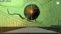
Silbury Hill 3D model
-
Silbury Hill 3D model
-
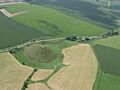
Aerial view of Silbury Hill and the A4 road
-
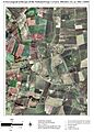
Silbury Hill with other ancient sites in the Avebury area (around 2600 to 2300 BC)


See also
 In Spanish: Colina de Silbury para niños
