
Skipsea meres facts for kids
The Skipsea meres were three lakes found near the village of Skipsea in the East Riding of Yorkshire, England. These lakes were called Skipsea Bail Mere, Skipsea Low Mere, and Skipsea Withow Mere. The name Skipsea itself means "lake" or "harbour for ships," which tells us how important water was to the area.
Most of these lakes formed naturally after the last Ice Age. One, Skipsea Mere, might have been dug by people to help defend Skipsea Castle. Over time, all the water from these meres has either dried up naturally or been drained by people, mostly to create land for farming.
Contents
History of the Skipsea Lakes
The three lakes at Skipsea have been around since the Holocene period, which is the time after the last Ice Age. During this period, melting glaciers created many hollows in the ground, some of which filled with water to form these lakes. These types of dried-up lakes are common in an area called Holderness, where the land is low and water doesn't drain away easily. In the past, Holderness would have looked a lot like the Norfolk Broads, with many areas covered in water. You can still see this in some local place names like Marfleet and Redmere.
Many of these lakes disappeared because people drained them to create more land for farming and animals. For example, Withow Mere was the most eastern lake, and its old location is now being worn away by the sea. Bail Mere was between the castle and the Church of All Saints. Low Mere was further to the north-west of the village.
Some studies suggest that Withow Mere might have been connected to Bail and Low Meres by a small channel. However, a ridge of land near Skipsea might have stopped them from joining up. People also wonder if boats could sail from the sea, through the meres, right up to the village and the castle. The village name, Skipsea, comes from old words meaning "lake for ships" or "harbour for ships."
The ground layers under all the meres show the same pattern built up over thousands of years. These layers include lake clays, silt, peat (decayed plant matter), and a topsoil layer. During the Middle Ages, the lakes in Skipsea and other parts of Holderness were a key source of food. Records from the 1300s show that eels from Skipsea Mere were valuable to catch and sell. Even in the late 1700s, when many lakes had been drained, people could still catch many ducks for food.
Skipsea Bail Mere: The Castle's Lake
The Skipsea Bail Mere, also known as Skipsea Mere, was located near Skipsea Castle. It helped protect the castle and was also on the west and north sides of the Church of All Saints. The castle itself is in Skipsea Brough, a small area near Skipsea. Part of the castle's defences was called a "bail," which gave the lake its name.
A dam was built north-west of the castle to hold water. The castle sat about 50 feet above the lake. Some people thought the lake was affected by tides from the sea. Others believe the lake was completely man-made, created only to defend the castle. A raised path, called a causeway, crossed the lake and connected the castle area to the Church of All Saints. There was also a wooden bridge over the lake that linked the castle's main tower (the keep) to its gate. Digs by archaeologists have found the remains of a wooden harbour that the castle used to move goods from ships.
Studies of pollen from Bail Mere show that the temperature right after the Ice Age was about 2°C warmer than it is today. Because this lake is so important for further study, it has been named a SSSI. The Bail Mere was also known as the castle's fishing spot. Most of the eels and fish caught were sold to people in the local area. The lake was drained around 1720, and the land was then used for farming.
Skipsea Low Mere: The Farther Lake
Skipsea Low Mere was the furthest lake from Skipsea village. It might have been connected to Bail Mere by a channel that drained water towards the sea. This channel now follows the path of a modern drain. Before it was drained, the Low Mere was about 7.5 metres above sea level.
Skipsea Withow Mere: The Eroding Lake
The name of Skipsea Withow Mere goes back to the 1200s. The name means "marsh near the white hill." However, it has also been called by other names like Fwitthouker and White Hole Carr.
The area where Skipsea Withow Mere once was is now being worn away by the waves from the North Sea. Bones found at the eastern edge of this lake were from red deer that lived during the Mesolithic era (Middle Stone Age). Archaeologists believe these bones were not from animals that died naturally, but were likely thrown into the lake after being hunted by humans. Studies of the ground layers at the lake site show that it was about 2 to 3 metres deep during the Late-Devensian period (a cold period during the last Ice Age). It stretched over 53 metres from north to south at its widest point.
Withow Mere was to the south-east of Skipsea. A ridge of land south of the village separated it from Bail Mere. The water flowing out of Withow Mere, called Withow Hole, was about 400 yards east of where the coastline is today. The lake itself covered an area of land that has been lost to coastal erosion since 1750.
Images for kids
-
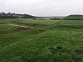
Skipsea Castle outside earth works. The castle was on the raised mound on the right; water would have submerged the low land in the foreground

