
Spurn facts for kids
Quick facts for kids Spurn |
|
|---|---|
 Spurn in May 2005, showing the lighthouse and sand-dunes. |
|

Spurn
|
|
| Population | 50 (approx) |
| OS grid reference | TA399108 |
| Civil parish |
|
| Unitary authority | |
| Ceremonial county | |
| Region | |
| Country | England |
| Sovereign state | United Kingdom |
| Post town | HULL |
| Postcode district | HU12 |
| Dialling code | 01964 |
| Police | Humberside |
| Fire | Humberside |
| Ambulance | Yorkshire |
| EU Parliament | Yorkshire and the Humber |
| UK Parliament |
|
Spurn is a thin strip of sand that stretches out into the North Sea from the coast of East Riding of Yorkshire, England. It forms the northern edge of the Humber Estuary. Spurn used to be connected to the mainland by a road. However, a big storm in 2013 made this road unsafe for cars during high tide. Now, Spurn is a tidal island, meaning the sea covers the narrowest part of the sandbank at high tide.
This sandy island is over 3 miles (5 km) long. In some spots, it's as narrow as 50 yards (46 m) wide. The very end of Spurn is called Spurn Head or Spurn Point. Here, you'll find a RNLI lifeboat station and two old lighthouses that are no longer used. Spurn is part of the area known as Easington.
The land above high water at Spurn Head covers 280 acres (113 ha). The sandy area that gets covered by the tide is 450 acres (181 ha). Since 1960, the Yorkshire Wildlife Trust has owned Spurn. It is a special national nature reserve. It's also a heritage coast and part of the Humber Flats, Marshes and Coast Special Protection Area. This means it's a very important place for nature.
Contents
Exploring Spurn's Past

People have known about Spurn Head for a very long time. Ancient writers like Ptolemy called it Ocelum Promontorium. In the Middle Ages, a port called Ravenspurn was located here. In 1399, Henry of Bolingbroke landed at Ravenspurn. He came back to England to take the throne from Richard II. Later, in 1471, Sir Martin de la See tried to stop Edward IV from landing here. Edward was returning from exile.
Another old village, Ravenser Odd, was also near Spurn Head. Like many villages along the Holderness coast, Ravenspurn and Ravenser Odd were lost to the sea. This happened because Spurn Head is always changing due to sand erosion and new sand being deposited. The land slowly moved westwards.

The lifeboat station at Spurn Head was built in 1810. Because it was so far away from towns, houses were built for the lifeboat crew and their families. Today, this station is one of the few in the UK with full-time paid staff. In the 1870s, a room in the tall lighthouse was used as a small church. It served the lighthouse keepers, coast-guards, and fishermen living at the Point.
During the First World War, two large coastal artillery batteries were built at Spurn Head. These had big guns to protect the coast. You can still see these old gun placements today. Some of the northern ones have partly fallen onto the beach. This shows how large their concrete foundations were.
Besides a road, Spurn also had a railway. You can still see parts of it. Unusual 'sail bogies' were used on this railway. These were like small carts with sails!
After the big tidal surge in December 2013, the road became unsafe. Now, you can only reach Spurn Point by walking. There are warnings not to go during very high tides. As mentioned, Spurn is now a tidal island. The narrowest part of the sandbank gets covered by water at every high tide.
In 2014, the Yorkshire Wildlife Trust (YWT) planned a new visitor center for the reserve. After some changes, the plans were approved in 2017. The new visitor center officially opened in March 2018.
How Spurn Was Formed

Spurn is made of sand, shingle, and clay. This material comes from the Holderness coastline, which is slowly worn away by the sea. The waves and currents carry this material down the coast. It then builds up to form the long, narrow strip of land inside the Humber Estuary. Plants like Marram grass help to keep the sand in place.
Waves carry material along the peninsula to its tip, making it longer. As it gets longer, it also gets narrower. Sometimes, in bad weather, the sea can cut right across it. When this happens, the part beyond the cut is washed away. But don't worry, a new spit usually forms again further south. This cycle of being destroyed and rebuilt happens about every 250 years.
However, a different idea about Spurn's formation has been suggested. Dr. John Pethick from Hull University thinks Spurn Head has been there since the end of the last ice age. He believes it grew on an underwater ridge left by glaciers. As the ice melted and sea levels rose, the sand built up. Normally, the sea washes over the narrow part of Spurn. It takes sand from the sea side and puts it on the land side. Over time, the whole spit moves back, but its tip stays on its glacial foundation.
This natural process has been affected by human efforts to protect Spurn. These protections stopped the sand from moving. As a result, Spurn is now more exposed. The rest of the coast has moved back 110 yards (100 m) since the protections were built. The old defenses are now crumbling and won't be replaced. Spurn will continue to move westwards by about 2.2 yards (2 m) each year. This will help it keep pace with the erosion happening further north.
Spurn Point was even featured in a piece of music! It's in the Andante sostenuto by Ralph Vaughan Williams, composed in 1926. It was also shown on the TV show Seven Natural Wonders as one of Yorkshire's wonders.
Wildlife at Spurn
The muddy areas on the landward side of Spurn are very important feeding grounds for wading birds. Spurn also has a bird observatory. This is a place where experts watch and study migrating birds. It also offers a place for birdwatchers to stay.
East winds in autumn help birds migrate from Scandinavia. Sometimes, thousands of birds arrive at Spurn in a spectacular "fall." Many rare birds have been seen here. These include a cliff swallow from North America and a lanceolated warbler from Siberia. A black-browed albatross from the Southern Ocean has also been spotted!
More commonly, birds like wheatears, whinchats, common redstarts, and flycatchers stop at Spurn. They are on their way between their breeding and winter homes. When the wind is right, migrating birds are guided down Spurn Point. They are counted at the Narrows Watchpoint. On a good autumn morning, over 15,000 birds can fly past, and 3,000 is quite normal.
Spurn's Lighthouses
 |
|
| Spurn Point | |
|
Spurn Point High
Location in East Riding of Yorkshire
|
|
| Location | Spurn Point East Riding of Yorkshire England |
|---|---|
| Coordinates | 53°34′44″N 0°07′06″E / 53.578996°N 0.118325°E |
| Year first constructed | 1895 |
| Automated | 1957 |
| Deactivated | 1985 |
| Construction | brick tower |
| Tower shape | cylindrical tower with balcony and lantern |
| Markings / pattern | white and black bands tower, white lantern |
| Height | 128 feet (39 m) |
| Original lens | 6-panel hyper-radial rotating catadioptric |
| Range | 17 nautical miles (31 km) |
| Characteristic | Fl W 15s. Oc RW (sector lights) |
| Admiralty number | A2424 |
| ARLHS number | ENG-138 |
The first mention of a lighthouse at Spurn Point was in 1427. From the 1600s, there are records of two lighthouses. These were kept as "leading lights" to guide ships. There was a tall "high light" and a shorter "low light."
Old High and Low Lights

In 1767, John Smeaton was asked to build a new pair of lighthouses. Smeaton's high light was a 90 feet [27 m] tower. It was used until 1895. But there were always problems with keeping the low light working. It was often washed away by the sea. Many temporary replacements were used over the years.
Finally, a stronger low lighthouse was built in 1852. It was designed by James Walker. This new low light was built on the estuary side (west) of the high light. The older ones had been on the sea side.
At first, both lighthouses burned coal for their lights. In 1819, Smeaton's high light got new lamps and reflectors. Later, in 1853, it received a new Fresnel lens. This was a very large lens that had been shown at the Great Exhibition of 1851. A red light was later added to the high light. This warned ships about dangers to the south.
The low light also got oil lamps and reflectors in 1816. In 1848, a smaller Fresnel lens was installed. This lens was reused when the new tower was built in 1852.

In 1895, both this low light and Smeaton's high light were replaced. A single new lighthouse was built, which still stands today. The 1852 low light also still stands on the sandy shore. However, its light has been replaced by a large water tank. Only the foundations remain of Smeaton's old high light.
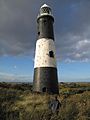
The New Spurn Lighthouse
The lighthouse built in 1895 is a round brick tower. It is 128 feet (39 m) high and painted black and white. Thomas Matthews designed it. The top of the lighthouse held a very large, spinning lens made by Chance Brothers & Co. Its white light could be seen from 17 nautical miles (31 km; 20 mi) away. It flashed once every 20 seconds.
There were also other lights that pointed to specific areas. Two of these marked dangerous sandbanks. Another showed the main channel for ships along the Humber. At first, the lighthouse used oil for light. In 1941, it was changed to electricity. This allowed the light to be turned on quickly when Allied ships needed it, and then turned off again.
In 1957, the lighthouse was changed to use acetylene gas. A new, smaller, gas-powered spinning light was put in. It flashed once every fifteen seconds. The other lights also became gas-powered and automated. This meant lighthouse keepers were no longer needed. Their cottages were taken down.
When the Light Went Out
Because navigation technology improved, the lighthouse light was turned off in 1985. The main lens was removed the next year. It was later put on display in museums. Since then, the lighthouse has been empty.
Bringing the Lighthouse Back to Life
In 2013, the Yorkshire Wildlife Trust received a grant to fix up the lighthouse. The plan was to reopen it as a visitor center. Work started in April 2015 and finished in March 2016. The lighthouse opened to the public for the Easter weekend that year.
Gallery
-
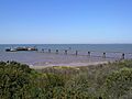
The pier and launching platform for the RNLI at Spurn
-
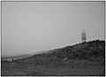
Sea mist
-
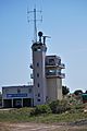
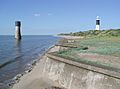
Humber Vessel traffic service
-
Spurn Point from the mainland
-
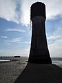
Old Spurn Point Low Light (1852)
-
The old Low Light (1852) seen alongside the new (1895) lighthouse
-
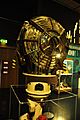
The 1957 optic in the National Maritime Museum


.jpg)
Images for kids
-
Lighthouse at Spurn Point
-
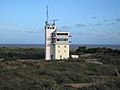
Humber Vessel traffic service
-
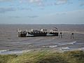
RNLI Platform


See also
 In Spanish: Cabo Spurn para niños
