
River Rea facts for kids
Quick facts for kids Rea |
|
|---|---|

The River Rea at Belgrave Middleway (Birmingham)
|
|
| Country | England |
| Physical characteristics | |
| Main source | Waseley Hills Country Park, Worcestershire |
| River mouth | Confluence with the Tame 52°30′15″N 1°50′37″W / 52.50417°N 1.84361°W |
| Length | 14 miles (23 km) |
| Basin features | |
| Progression | Rea → Tame → Trent → Humber → North Sea |
The River Rea (say "ray") is a small river that flows through Birmingham, England. It's a very important river because the city of Birmingham was started right next to it. The Beorma tribe built the first settlement here in the 7th century.
Contents
What's in a Name?
The name "Rea" comes from a very old word. This word is found in many different languages from Europe and Asia. It simply means "to run" or "to flow," which is perfect for a river!
Where Does the River Rea Flow?
The River Rea starts in Waseley Hills Country Park. You can even see where it begins from the park's car park! At first, the river drops quite a bit, about 70 meters (230 feet) in its first mile. But after that, it flows much more gently.
The Rea has several smaller streams that flow into it. These are called tributaries. Some of its tributaries include Callow Brook, the Bourne (which starts as Merritts Brook and then joins Griffins Brook), and Bourne Brook.
From Rubery, the river flows into Birmingham. It goes near the old Rover car factory at Longbridge. Then, it flows through a tunnel under the A38 main road.
In Northfield, you can find one of the few remaining fords on the river. A ford is a shallow place where you can cross a river on foot or by vehicle. This one is at The Mill Walk, near Hawkesley Mill Lane. After this, the railway line to Kings Norton also follows the river valley.
Wychall Reservoir and Birmingham's History
Near the river at Kings Norton, there's a place called Wychall Reservoir. It was built a long time ago, in the early 1800s. It was built by the Worcester Canal Company. This happened because owners of watermills along the river said that the canal was taking too much water. This made it harder for their mills to work properly.
After Kings Norton, the river flows through Stirchley. For much of its journey through Birmingham, the river is now culverted. This means it flows underground in pipes or tunnels. It passes under areas like Pebble Mill, Cannon Hill Park, and Calthorpe Park.
You can see two special arches on the bridge where Gooch Street crosses the river. These arches mark the spot where Birmingham was first settled. The old village of Birmingham was built on a crossing point over the Rea in an area now called Digbeth. Many street names in this area remind us of the river or the mills that used its water. These include Rea Street, Floodgate Street, River Street, and Duddeston Mill Road.
There are plans to make the river more visible in the Warwick Bar area of Digbeth. There are also proposals for a riverside walk and a new bridge near the Custard Factory, which is a cool place for media and arts.
Journey to the Sea
Near a big road junction called Gravelly Hill Interchange, about 14 miles (23 km) from where it starts, the River Rea joins a bigger river called the River Tame. From there, the water travels even further! It flows into the Trent, then into the Humber Estuary, and finally reaches the North Sea.
Stopping Floods
The River Rea can sometimes overflow its banks when there's a lot of heavy rain. To help with this, a big project costing £2.7 million was finished in January 2018. This project helps protect more than 200 homes and businesses in the south of Selly Park from flooding.
See also
Images for kids
-
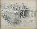
A floodgate on the river at Vaughton's Hole (now Vaughton St), Highgate, Birmingham, drawn in 1831 by Henry Harris Lines
-
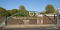
One of the Gooch Street Bridge arches


