
Northfield, Birmingham facts for kids
Quick facts for kids Northfield |
|
|---|---|
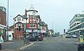
 View of Bristol Road South at Northfield looking north towards Selly Oak |
|

Northfield
|
|
| Population | 10,404 (2021 people Ward) |
| • Density | 4,470/km2 |
| OS grid reference | SP025795 |
| Metropolitan borough | |
| Metropolitan county | |
| Region | |
| Country | England |
| Sovereign state | United Kingdom |
| Post town | BIRMINGHAM |
| Postcode district | B31 |
| Dialling code | 0121 |
| Police | West Midlands |
| Fire | West Midlands |
| Ambulance | West Midlands |
| EU Parliament | West Midlands |
| UK Parliament |
|
Northfield is a residential area located in the southern part of Birmingham, England. It's close to the border of Worcestershire, which it used to be a part of a long time ago. Northfield is also a special area called a council constituency. This means it has its own local committee that helps manage things. This area includes smaller parts called wards, like Kings Norton, Longbridge, Weoley Castle, and Northfield itself, which includes West Heath and Turves Green.
Northfield was mentioned in the Domesday Book, which is a very old survey from 1086. It started as a small village in north Worcestershire. In 1911, it became part of Birmingham after growing a lot before World War I. The northern part of Northfield is even part of the Bournville model village. The houses in the south were first built by Austin Motors for their workers.
In the 1800s, Northfield was a big center for making nails. Later, in the 1900s, it was home to the Kalamazoo paper factory and the Austin motor company's Longbridge factory. Today, Northfield is mostly a place where people live and travel from to work in other parts of Birmingham. The main A38 goes right through Northfield, connecting Birmingham to places like Bromsgrove and even Cornwall.
Contents
History of Northfield
Early Times in Northfield
People lived in or visited Northfield during the Stone Age. We know this because tools like a yellow Chert scraper and a stone axe-head were found here. These tools are from the New Stone Age. It's also possible that people lived here during the Bronze Age. Large mounds of burnt stones have been found near Northfield's streams. These mounds show that people lived in the area for a long time. One mound near Merritts Brook Lane is 16 meters wide. Other mounds have been dated to around 1070 BCE and 1120 BCE. These hot stones might have been used for cooking or even as Bronze Age saunas.
Roman, Saxon, and Norman Periods

Before Roman times, the area around Northfield was likely home to the Celtic tribe called the Dobunii. There isn't much proof of Saxon settlements, so the area was probably mostly Celtic.
The name "Northfield" comes from the Anglo-Saxon phrase nord feld. It was probably named because it is north of Bromsgrove. Northfield was also near the northern edge of the Saxon kingdom called Hwicce. This included places like Kings Norton and Yardley.
The path that is now the Bristol Road South through Northfield was known as the Upper Saltway. This was part of the historic Ryknild Street. It was used to carry salt from Droitwich all the way to Saltfleet on the Lincolnshire coast. From there, the salt was shipped to France and Scandinavia for trade.
The Romans also used this road often. Roman items were found by accident in Northfield around 1921. When Pigeon House was taken down, a collection of 16 Roman coins was found buried. These coins were from different Roman emperors. An old Roman aqueduct was also found, showing that an important Roman building once stood there. In 1963, another Roman coin was found nearby. This coin was from the time of Emperor Antoninus Pius, who ruled from 138 to 161 AD. It was a small brass coin, worth about the price of a loaf of bread.
Northfield was part of a Saxon settlement or a Celtic area that Saxons had taken over. In 1086, it became part of the lands of William Fitz-Ansculf, a Norman knight. The village of Nordfeld was described in the Domesday Book. It had a priest, farmers, and even some enslaved people. St. Laurence's Church, Northfield was built in the 1100s. Nearby is the Great Stone Inn, which has a medieval timber-framed hall. There's also a 17th-century village pound where stray animals were kept. The large rock in the pound is a glacial "erratic" (a rock moved by a glacier). It used to be in the road and was used by horse riders to get on their horses. It was moved in the 1950s for road safety. The area around the church, inn, and pound is a special conservation area because of its history.
English Civil War Period
During the English Civil War, Northfield was on the border between the Royalist (King's side) area of Worcestershire and the Parliamentarian (Parliament's side) area of Warwickshire. Because of this, there were often small fights between the two sides. Hawkesley House in West Heath belonged to a Royalist family. Parliamentarian forces took it over and made it stronger. But Royalist forces took it back in May 1645, and the house was then destroyed. Prince Rupert of the Rhine, who led the Royalist cavalry, stayed in Longbridge House during the fight for Hawkesley House. Hawkesley House is now an archaeological site, meaning people study its remains.
Some stories say that Henry Tudor, who later became King Henry VII, slept in Selly Manor on his way to the Battle of Bosworth Field. It's also said that Robert Catesby (from the Gunpowder plot) and Oliver Cromwell (a famous leader during the Civil War) both visited Northfield and stayed at Selly Manor House.
Northfield in the 1800s

In the early 1800s, Northfield was known for making nails. Many people worked from their homes or small workshops near the Church. In 1831, 122 men were recorded as nail makers. However, this industry started to decline. By 1884, only 23 nailers were left. By the early 1900s, nail making moved to factories in central Birmingham, and it was no longer a home-based industry. There were also grain mills on the River Rea where local crops were ground.
Northfield was on the main road between Birmingham and Worcester. In 1762, this road became a turnpike, meaning you had to pay a toll to use it. The Northfield tollgate was where Rochester Road is today. This old turnpike is now known as the Bristol Road South. The 'Bell and Bluebell Inn' was a stop for travelers until a new 'Bell Inn' was built on the Bristol Road in 1803. There was also a small group of cottages on Bell Lane from the late 1700s and early 1800s that are still there today.

In 1870, Northfield railway station opened, bringing new business chances. Charles Pegram, a local business owner, built houses for railway workers. He also built a roller skating rink and a temperance hotel (a hotel that didn't serve alcohol) near the station.
Northfield in the 1900s
Victoria Common is a public park that was planned in 1897 to celebrate Queen Victoria's Diamond Jubilee. It opened to the public in 1901. The park looks much the same today, though trees have grown. Tennis courts were added in the 1930s, and a children's play area was built in the 1950s. A small stream used to run through the park but was put underground during the landscaping. The original entrance gates and park buildings were on the Bristol Road South, where the Northfield Shopping Centre is now.

In the early 1900s, the Austin Motor Works and Kalamazoo factories came to the area. They offered many good jobs to people in Northfield.
In 1900, visitors arriving at Northfield railway station could go to the skating rink on West Heath Road. During World War I, this rink was used to make weapons. Sadly, it was destroyed by fire after an accident. Another famous building was The Bath Tub, an outdoor swimming pool. It opened in 1937 with a big ceremony attended by 20,000 people and famous singer Gracie Fields. The lido had a large swimming pool, a putting green, and a playground. It only stayed open for three years because it didn't make enough money. During World War II, a company called Laughtons used the site. The lido site is now covered by houses.
Northfield Library serves the area. It opened in 1906 but was destroyed by fire in 1914. People thought Suffragettes might have set the fire. It was rebuilt the same year. The front of the building looks the same, but in 1984, the library was made twice as big. The library celebrated its 100th birthday in 2006. West Heath library also serves the area.
Around 1900, Northfield was still a village in the countryside of north Worcestershire. The Austin Village was built during World War I to house factory workers. Northfield became part of Birmingham in 1919. Within 20 years, many new houses were built by private companies and the council. This made Northfield a full part of Birmingham. House building continued before and after World War II.
By 1900, a large old house called Gainsborough House became The Priory. It was home to a convent with nuns and girls. The Priory grounds had a woodland walk and a big lake. The Priory was taken down in the 1990s. Now, modern houses and an extension to the Royal Orthopedic Hospital stand there.

Birmingham Corporation Tramways ran electric trams in Birmingham from 1904 to 1953. It was the largest narrow-gauge tram network in the UK. The tram tracks ran along the middle of the Bristol Road South through Northfield. Cars had to give way to the trams. The tram routes through Northfield closed in 1952. Over the years, the tracks were covered with tarmac during road repairs.
A large housing area in Northfield is the Egghill Estate. The city council built it in the 1950s and 1960s, with many homes and tall apartment buildings. By the 1980s, the estate had problems with crime and old housing. In 2000, the council decided to tear down the whole estate to build new homes. However, this rebuilding is still not finished. Some old houses remain, and only a few new homes have been built. Most of the estate is still empty and undeveloped. When it's finished, the new Egghill Estate should have better shops and community places.
Northfield also has many council houses, maisonettes, flats, and tower blocks built before and after the wars.
Governance in Northfield
Historical Governance
In the Middle Ages, Northfield was part of the Halfshire Hundred in Worcestershire.
National Government (Westminster)

Birmingham Northfield is a special area that elects one person to the UK Parliament. This person is called a Member of Parliament (MP). The current MP for Northfield is Gary Sambrook from the Conservative Party (United Kingdom), who was elected in 2019.
Local Council (Birmingham City Council)
The person elected to represent the Northfield ward on the Birmingham City Council is Kirsten Kurt-Elli from the Labour Party (United Kingdom).
Geography of Northfield
Northfield's Geology

Northfield is built on gravel and sand that drains water well. This land was formed under an ancient shallow sea and later by ice age glaciers. The natural heathland grew on a flat area between the nearby Lickey Hills and Redhill. Northfield has many different types of rocks from various ages. These rock layers create the area's varied landscape and natural habitats.
Some of the rocks found here include:
- Barnt Green rocks: Very old volcanic rocks.
- Lickey Quartzite: A hard rock called quartzite.
- Rubery sandstone: Sandstone with fossils.
- Keele Clay: A type of clay.
- Clent Breccia: A rock made of angular fragments of volcanic rock. This is the most common sandstone under central Northfield.
- Bunter Pebble Beds: Layers of smooth, water-worn pebbles.
- Keuper marl: A type of sandstone. Deep wells dug into these layers used to provide Birmingham with drinking water.
Northfield is on a small part of the Northfield—Dudley plateau. This area was covered by a huge glacier from Wales about 10,000 to 13,000 years ago. We know this because of the many Erratic boulders found here. These are large stones carried by ice from far away, some from Scotland or Wales. The massive boulder that the Great Stone Inn is named after is one of these. It sat at the corner of Church Hill and Church Road for thousands of years until it was moved in the 1950s. The ground under Northfield also has a coal seam, which means a large ancient tropical forest once grew here.
Waterways in Northfield

The River Rea flows through Northfield. It starts in Waseley Hills Country Park and then goes through Northfield, West Heath, and on to Kings Norton and Selly Oak. Near Gravelly Hill Interchange, about 14 miles from its start, the Rea joins the River Tame. Its waters eventually flow into the North Sea through the River Trent and the Humber Estuary. Much of the River Rea is now covered by pipes underground in Birmingham. It's often just a small trickle today, but it used to be a big waterway. It powered several mills in West Heath and supplied water for the old skating rink and outdoor swimming pool.
A small stream called Griffin's Brook flows through Northfield's Victoria Common. It runs parallel to Heath Road South on its way to Bournville. Most of it is now piped underground. It only comes to the surface briefly to feed a pond and then flows into the main Griffin's Brook. In the 1700s, Griffin's Brook often flooded.
Merritt's Brook starts as springs in fields southwest of Northfield. It flows parallel to the Bristol Road South until it reaches the lake at Manor Farm. From there, it joins Griffin's Brook.
Roads in Northfield
The A38 Bristol Road South connects Birmingham to Worcester and eventually Cornwall. It passes through Northfield. The M42 and M5 Motorways are also nearby. These motorways provide connections to other parts of the country.
 |
Bartley Green, Woodgate Valley Country Park | Weoley, Manor Farm Country Park, West Bromwich | Selly Oak, Bournville, Balsall Heath, Central Birmingham | |
| Frankley, Clent Hills | Kings Norton, Stirchley, Yardley Wood, Shirley, Solihull | |||
| Longbridge, Rubery, M5 motorway, Cofton Hackett, Lickey Hills Country Park, Waseley Hills Country Park, Bromsgrove | Hopwood, Alvechurch | West Heath, Turves Green |
Industry in Northfield

Northfield is perhaps most famous for the Longbridge plant, a large car factory in the Longbridge area. This factory was built in 1905 to make Austin cars. It grew over the years to build many more vehicles under different car companies like British Leyland and Rover Group. In 2005, the MG Rover company had to close, and over 6,500 jobs were lost. A Chinese carmaker, Nanjing Automobile, bought the factory a few months later. They started making MG TF sports cars again in 2007 with about 200 workers. However, most of the factory site was taken down. There are plans to build a new town center for Longbridge with new shops, parks, and homes. This will help with the job losses from the Rover factory closing.
In 1913, Oliver Morland and local businessman F Paul Impey moved their Kalamazoo paper factory from central Birmingham to a large site near Northfield and Longbridge. This factory became a big supplier of business paper and computer forms. It mostly employed women workers until it closed in the 1980s. Kalamazoo then moved into the IT industry, focusing on computer systems for car dealerships. Today, the company, now called Reynolds and Reynolds UK, still operates at the site in Northfield.
Population of Northfield
The 2021 Population Census counted 10,404 people living in the Northfield ward. This means there were about 4,470 people per square kilometer. The percentage of people from ethnic minority groups is lower here compared to Birmingham as a whole. The largest religious group in Northfield is Christianity, with 56.5% of the population.
Education in Northfield
Secondary Schools
Some secondary school students from Northfield go to Turves Green Boys' School or King Edward VI Northfield School for Girls. Northfield is also close to other secondary schools, so some students travel to:
- Colmers School and Sixth Form College in Rednal
- Kings Norton Boys School in Kings Norton
- Kings Norton Girls School in Kings Norton
- Bournville School in Bournville
- Shenley Academy in Weoley Castle
- St Thomas Aquinas Catholic School in Kings Norton
- Balaam Wood School in Frankley
- St. Paul's School for Girls in Edgbaston
Primary Schools
- Meadows Primary, Bristol Road South
- Turves Green Primary
- The Orchards Academy (formerly Ley Hill Junior), Rhayader Road
- Bellfield Junior, Vineyard Road
- Wychall Primary, Middle Field Road
- Trescott Primary, Trescott Road
- Cofton Primary, Wootton Road
- St Brigid's Catholic Primary, Frankley Beeches Road
- St John Fisher Roman Catholic Primary, Alvechurch Road
- Woodcock Junior, Far Wood Road
- St. Laurence Church School, Bunbury Road
Religious Sites in Northfield
.jpg)
- Hollymoor Community Church, The Old Chapel, Manor Park Grove
- St. Laurence's Church, Church Hill (dating from the 12th century)
- St Bartholomew's Church, Hoggs Lane & Allens Farm Road
- Our Lady And St Brigids Roman Catholic Church, Frankley Beeches Road
- Northfield Methodist Church, Chatham Road
- Northfield Baptist Church, 789 Bristol Road South
Sporting Facilities in Northfield

- North Worcestershire Golf Club on Frankley Beeches Road opened in 1907. It closed in 2016. The land is planned to be redeveloped for homes, a new primary school, and a community center.
- Northfield Town F.C. – This football club started in the 1950s. The team is now based on Shenley Lane, Selly Oak.
- Northfield Swimming Pool and Fitness Centre – The original building opened in 1937. This Art Deco building was taken down in 2017 to be replaced by a modern one.
- Other gyms in the area include Everlast, Urban Fitness, and Nuffield Health.
Local Services in Northfield
Hospitals in Northfield

Northfield is served by the NHS Trust Selly Oak Hospital. This hospital is moving to new buildings soon. Part of it is used to treat military patients and make prosthetic limbs.
The special Royal Orthopaedic Hospital is on the Bristol Road South. George Cadbury bought the land in 1909 and gave it to a children's charity to be used as a hospital. A new £8 million outpatient department opened in 2011.
Hollymoor Hospital, a hospital for mental health, was built in Northfield in 1905. It was used as a military hospital in World War II. It closed in 1995 and most of it has been taken down.
Shopping in Northfield
.jpg)
The former Grosvenor shopping center is now called 'Northfield Shopping Centre'. It has many well-known stores like Wilko, Iceland, WH Smiths, and New Look. There's also a cobbler for shoe repairs. The shops in Northfield town center are along what used to be the main A38 road. Other stores include Home Bargains, Aldi, and a Sainsbury's supermarket. There is also a covered market. This shopping area serves many people from Northfield and nearby areas.
In 2010, the Northfield Radio Link scheme started. It helps shops, security, and the police share information quickly to make the town safer.
A traditional farmers' market is held on the second Saturday of each month at Kings Norton Green. A car boot sale is held most Saturdays in a field on Merrits Brook Lane.
Public Facilities
Northfield town center has several public facilities. These include Northfield Library, Northfield Community Partnership (which helps people find jobs and offers community support), Connexions (which helps young people find jobs), The Shop (advice for young people), Citizens Advice Bureau, Northfield Neighbourhood Office, Northfield Ecocentre, and Victoria Common park.
Transport in Northfield
The area has two train stations: Northfield railway station and Longbridge railway station. Both are on the Cross-City Line. Several bus routes also go through Northfield, operated by different companies.
Northfield is centered on the main A38 road. This road goes south from Birmingham to places like Bromsgrove, Worcester, and Exeter. The section of this road through Northfield used to be very busy. But in 2006, a new relief road was built, which has made traffic much better. The new road includes "Sir Herbert Austin Way," named after Herbert Austin, 1st Baron Austin who started making cars at the Longbridge plant.
Annual Carnival
The Northfield Carnival usually happens every year on the first Saturday of July. It is run by volunteers and takes place in Victoria Common, a park behind Northfield Shopping Centre.
Notable People from Northfield
- Jane Bunford – Britain's tallest person ever.
- George Byrne – England cricketer.
- George Cadbury – famous industrialist and founder of the chocolate brand.
- Jocelyn Cadbury – helped the public and was a Member of Parliament.
- Lewis Goodall – Journalist and Broadcaster.
- Ian Lavender – actor, known as Private Pike in Dad's Army.
- The Rockin' Berries – a pop band from the 1960s.
- Stuart Linnell – broadcaster.
- Sarah Smart – actress, lived in Northfield until 1987.
- The Stratocastors – an Indie rock band.
Images for kids
-
View of Bristol Road South at Northfield looking north towards Selly Oak
