River Bourne, Warwickshire facts for kids
Quick facts for kids River Bourne |
|
|---|---|

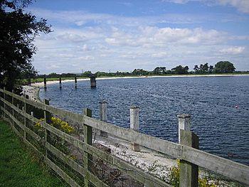
Shustoke Reservoir is supplied by the Bourne
|
|
| Country | England |
| Counties | Warwickshire |
| Physical characteristics | |
| River mouth | Warwickshire 52°31′18″N 1°41′00″W / 52.5217°N 1.6834°W |
| Length | 17.6 km (10.9 mi) |
| Basin features | |
| Basin size | 47 km2 (18 sq mi) |
| Tributaries |
|
| Progression : Bourne—Tame —Trent—Humber | |
The River Bourne is a river in England. It flows for about 10.9 miles (17.6 km) through North Warwickshire. This river is a smaller stream that joins a larger one, making it a tributary of the River Tame. A long time ago, in the 1800s, people chose this river to help provide clean drinking water for the city of Birmingham.
Contents
Where Does the River Bourne Flow?
The River Bourne starts between Ansley Common and Birchley Heath. This area is south-west of Atherstone. At first, it's just a small stream called the Bourne Brook.
Journey of the River
The river flows south-west, passing by Church End. It goes past Ansley Mill, where a small road crosses it. It continues in the same direction, flowing between New and Old Arley. Here, it meets the Didgley Brook, which drains water from around Fillongley.
After joining Didgley Brook, the stream officially becomes the River Bourne. It then turns north-west, flowing past Slowley Hall. It also passes the old site of Daw Mill Colliery, which was once a coal mine.
The river continues to Furnace End. Here, it is joined by another stream called Whitacre Brook. The River Bourne then turns west and flows next to Shustoke Reservoir. After this, it joins the River Tame. This meeting point is downstream from where the River Blythe joins the Tame.
River's Catchment Area
The area that collects rainwater for the River Bourne is called its drainage basin. This basin is located between the River Blythe's basin to the south and west, and the River Anker's basin to the north and east. The River Bourne's basin covers an area of about 47 square kilometres (18 sq mi).
How the River Helps with Water Supply
The River Bourne plays an important role in providing water. Raw water, which means untreated water, is taken from the river. This water is then stored in the Shustoke reservoirs. The main reservoir holds water that is cleaned and used for drinking. It supplies water to different parts of Warwickshire, including towns like Atherstone and Bedworth.
River Health and Ecology
Scientists check the health of rivers and streams. They look at the "ecological quality," which means how healthy the environment of the river is. This includes checking the water, plants, and animals.
Quality of the Streams
The different streams that make up the River Bourne system have been checked. Their ecological quality is rated on a scale from "high" to "bad." Unfortunately, the streams in the River Bourne area are at the lower end of this scale.
- The upper part of the Bourne has been rated as "bad."
- Didgley Brook is rated as "moderate."
- The lower part of the Bourne is rated as "poor."
This means there are things that could be improved to make these parts of the river healthier for nature.
 | Dorothy Vaughan |
 | Charles Henry Turner |
 | Hildrus Poindexter |
 | Henry Cecil McBay |

