Wednesbury Old Canal facts for kids
Quick facts for kids Wednesbury Old Canal |
|
|---|---|

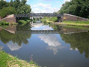
Pudding Green Junction. The Wednesbury Old Canal leads under the bridge from the BCN Main Line, which runs left and right
|
|
| Specifications | |
| Length | 4.4 miles (7.1 km) |
| Status | part open, part dry |
| Navigation authority | Canal and River Trust |
| History | |
| Principal engineer | James Brindley |
| Date of act | 1768 |
| Date of first use | 1769 |
| Date closed | 1955, 1960 |
| Geography | |
| Start point | Pudding Green Junction (originally Spon Lane Junction) |
| End point | Balls Hill Basin |
| Branch of | Birmingham Canal Navigations |
The Wednesbury Old Canal is an important part of the `Birmingham Canal Navigations` (BCN) in the `West Midlands (county)`, `England`. It first opened way back in 1769. While some parts of it were closed in 1955 and 1960, a section is still open for boats.
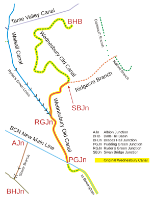
This open part runs between Pudding Green Junction and Ryder's Green Junction. It's important because it connects to the `Walsall Canal`. There's also a short bit beyond Ryder's Green Junction that's linked to the canal network, but it's very tricky to use.
Exploring the Canal's Path
The Wednesbury Old Canal starts at Pudding Green Junction. Here, it leaves the main Birmingham canal line. As it travels, you'll see lots of industrial areas around it.
At Ryder's Green Junction, the `Walsall Canal` begins its journey down eight locks. Just before these locks, the Wednesbury Old Canal turns off. It then winds its way through `Swan Village`. Originally, it even went around coal mines! The part of the canal past Swan Bridge Junction was also known as the Balls Hill Branch.
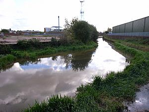
Today, boats can only go as far as the `Black Country Spine Road`. This is because a new bridge was built there that doesn't have enough space for boats to pass under. Even this section is often very overgrown and hard to navigate.
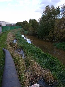
Beyond this point, the Wednesbury Canal is dry. However, the `Ridgacre Branch` continues. Most of its original length still has water, even though it's cut off from the main canal by a road. Boats can't use it, but it's now a great place for fishing, walking, and is home to lots of wildlife.
Some maps today show the Ridgacre Branch starting at Ryder's Green Junction. But, if you look at old records, that's not where it originally began.
A Look Back: The Canal's History
The Wednesbury Canal was one of the very first canals built in the `Black Country` or `Birmingham` area. It was part of the first big plan for the `Birmingham Canal`.
Building the canal was approved by a special law, called an `Act`, in 1768. This law allowed for the Birmingham Canal and its branches to Wednesbury and Ocker Hill.
The Wednesbury Canal was a major branch. It was finished and already delivering coal to Birmingham by November 6, 1769. This was even before the main Birmingham Canal had reached Wolverhampton!
The canal originally started at what is now `Spon Lane Junction`. From there, it went down three locks to a lower level. The canal was about 4.4 `4.4 miles (7.1 km)` long. It ended at Balls Hill Basin, which was near where the `Tame Valley Canal` was later built.
The `Ridgacre Branch` opened in 1826 and was about 0.75 `0.75 miles (1.21 km)` long. It started from the Wednesbury Canal at Swan Bridge Junction. From the Ridgacre Branch, other smaller branches like the Dartmouth Branch and the Halford Branch went off to different coal mines.
Later, a new, straighter canal line was built by `Thomas Telford`. This new line, called the `BCN New Main Line`, cut through the original Wednesbury Canal. This created Pudding Green Junction. The short, curved part of the Wednesbury Canal between Pudding Green and Bromford Junction was then removed.
The Wednesbury Old Canal was officially marked as 'abandoned' by laws passed in 1955 and 1960. More recently, new road projects, like the Black Country New Road, have cut off the connection to the parts of the canal that are still open. They also separated the Ridgacre Branch from the rest of the canal network.
Special Spots Along the Canal
Here are some interesting places and features along the Wednesbury Old Canal:
| Point | Coordinates (Links to map resources) |
OS Grid Ref | Notes |
|---|---|---|---|
| Balls Hill Basin | 52°32′24″N 2°00′58″W / 52.5401°N 2.0161°W | SO989936 | Original end point of the canal |
| Site of GWR aqueduct | 52°32′24″N 2°01′00″W / 52.5401°N 2.0168°W | ||
| Balls Hill Branch route (dry) 9 | 52°32′24″N 2°01′02″W / 52.5401°N 2.0172°W | ||
| Balls Hill Branch route (dry) 8 | 52°32′29″N 2°01′06″W / 52.5414°N 2.0183°W | ||
| Balls Hill Branch route (dry) 7 | 52°32′25″N 2°01′22″W / 52.5402°N 2.0227°W | ||
| Balls Hill Branch route (dry) 6 | 52°32′22″N 2°01′36″W / 52.5395°N 2.0267°W | ||
| Balls Hill Branch route (dry) 5 | 52°32′15″N 2°01′30″W / 52.5374°N 2.0250°W | ||
| Balls Hill Branch route (dry) 4 | 52°31′56″N 2°01′39″W / 52.5323°N 2.0274°W | ||
| Balls Hill Branch route (dry) 3 | 52°31′56″N 2°01′27″W / 52.5322°N 2.0243°W | ||
| Balls Hill Branch route (dry) 2 | 52°32′00″N 2°01′22″W / 52.5334°N 2.0227°W | ||
| Balls Hill Branch route (dry) 1 | 52°31′50″N 2°01′03″W / 52.5305°N 2.0174°W | ||
| Site of Swan Village Basin | 52°31′48″N 2°01′06″W / 52.5301°N 2.0184°W | A basin where goods were moved to and from the `GWR` | |
| Swan Bridge Junction | 52°31′46″N 2°00′59″W / 52.5294°N 2.0163°W | SO988924 | Now covered over by a road |
| Ridgacre Branch | 52°31′46″N 2°00′57″W / 52.5294°N 2.0157°W | SO989924 | |
| Black Country New Road | 52°31′45″N 2°01′01″W / 52.5292°N 2.0170°W | SO988924 | A road that blocks the canal |
| Ryder's Green Junction | 52°31′22″N 2°01′20″W / 52.5228°N 2.0221°W | SO985916 | Where the `Walsall Canal` begins |
| Pudding Green Junction | 52°30′50″N 2°01′00″W / 52.5139°N 2.0168°W | SO988907 | Connects to the `BCN New Main Line` (Island Line) |
| Lost loop | 52°30′44″N 2°00′53″W / 52.5123°N 2.0147°W | ||
| Bromford Junction | 52°30′25″N 2°00′18″W / 52.5070°N 2.0051°W | SO996899 | |
| Spon Lane bottom lock | 52°30′26″N 2°00′15″W / 52.5071°N 2.0041°W | SO997899 | |
| Spon Lane middle lock | 52°30′25″N 1°59′58″W / 52.5070°N 1.9994°W | SP000899 | |
| Spon Lane top lock | 52°30′24″N 1°59′44″W / 52.5067°N 1.9956°W | SP002899 | |
| Spon Lane Junction | 52°30′24″N 1°59′42″W / 52.5066°N 1.9951°W | SP003898 | Connects to the `BCN Old Main Line` |
 | Bayard Rustin |
 | Jeannette Carter |
 | Jeremiah A. Brown |


