
Bradley Branch facts for kids
Quick facts for kids Bradley Branch |
|
|---|---|

Lock No. 1 lies beneath the West Midlands Metro
|
|
| Specifications | |
| Length | 0.6 miles (0.97 km) |
| Locks | 9 |
| Status | Filled in |
| History | |
| Date completed | 1849 |
| Date closed | 1950s |
| Geography | |
| Start point | Wednesbury Oak |
| End point | Moorcroft Junction, Moxley |
| Branch of | Birmingham Canal Navigations |
The Bradley Branch or Bradley Locks Branch was a short canal in the West Midlands, England. It was part of the large network of canals known as the Birmingham Canal Navigations. The canal was finished in 1849. It had nine special locks and several basins. These basins helped connect the canal to local coal mines and factories. The locks were unusual because they had only one gate at each end. Most locks had two gates at the bottom. The Bradley Branch closed in the 1950s. The top seven locks were later covered up and landscaped.
Since 2008, people have been talking about reopening the canal. A study in 2015 showed that reopening it was possible. This project is now called the Bradley Canal. It would bring back the Bradley Branch. It would also connect to other old canal routes. The main group pushing for this is the Birmingham and Black Country Wildlife Trust. They believe that boats using the canal will help keep the area healthy. This includes benefits for nature and local communities.
Contents
Exploring the Bradley Canal's Past
The area around Bradley and Wednesbury was once full of coal and iron mines. A famous iron maker named John Wilkinson built a furnace and ironworks nearby. The main canal route, called the Old Main Line, twisted through this area. It was built following a specific height contour. This canal was approved by a special law in 1768. It opened for boats in 1772.
Another canal, the Broadwaters Canal, was built nearby. It connected to the main line through eight locks. These locks lowered the canal's level. This canal later became known as the Walsall Canal. Many smaller branches were built from the Broadwaters Canal. These branches helped serve the growing coal mining areas.
How the Bradley Branch Was Built
A branch to the Gospel Oak colliery was planned in 1783. However, instead of building locks there, they decided to build the Bradley Hall Extension. This extension was approved in 1794. It would leave the Broadwaters Canal at Moorcroft Junction. It would then rise through three locks to reach the Bradley Hall colliery. The mines were responsible for providing water for these locks. The branch opened in 1796.

The BCN Old Main Line was later replaced by a straighter route in the 1830s. This new route included the Coseley Tunnel. The old section then became known as the Wednesbury Oak Loop. Over time, the Loop was also shortened. This happened when the Rotton Brunt Line was built. This new line cut across a large bend in the canal.
In 1840, the Wyrley and Essington Canal joined the Birmingham Canal Navigations. New links were made between these canal systems. Six new locks were built in a straight line. These connected the Rotton Brunt Line to the Bradley Hall line. The Bradley Hall line was also straightened and its three locks rebuilt. This new section opened in 1849. It became known as the Bradley Branch or Bradley Locks Branch. It closed to boats in the 1950s.
Unique Lock Design
When the Bradley Branch was built, it was made quite wide. The locks were placed on the northern side of the canal. This was different from most older locks on the BCN. This design likely made it easier to build more locks if needed. This setup also created large lagoons on the southern side of each lock. These lagoons helped hold more water in the short sections between locks. The locks had a single gate at both the top and bottom. Most other BCN locks had double gates at the bottom.
After the canal closed, the top seven locks were filled in. The land was then landscaped. It is believed that the original locks and stone walls are still mostly there, buried under the ground. The bottom two locks were partly restored with a special grant. They were then filled in again to protect them. This was done with the hope of fully restoring them later. The section between the bottom lock and Moorcroft Junction is still filled with water. It is at the same level as the Walsall Canal. However, it is very overgrown.
Future Plans: Restoring the Bradley Canal
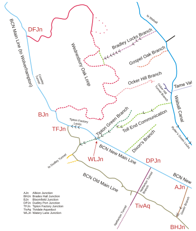
| Map of Wednesbury Oak Loop (pink), an original part of James Brindley's Birmingham Canal. The Bradley Branch (top) linked the BCN Old Main Line and the Walsall Canal through nine locks. |
Before 2008, the Birmingham Canal Navigations Society suggested restoring the Bradley Branch. They thought it would create new circular routes for boats. The only major problem was a bridge at the end of the Wednesbury Oak Branch.
In 2013, a group called the West Midlands Waterway Partnership decided to find money for a detailed study. This study would look into restoring the Bradley Canal. Many groups helped fund this report. These included the Canal & River Trust and the Inland Waterways Association. The study was completed in late 2015. It found that restoring the canal was indeed possible.
Benefits of Reopening the Canal
The goal of the restoration is to create a direct route for boats. This route would connect the Wolverhampton Level of the Birmingham Canal to the Walsall Canal and the Tame Valley Canal. The project is called the 'Bradley Canal' to avoid confusion. It includes the Bradley Branch and parts of other old canal sections. The affected section is about 1.5 miles (2.4 km) long. It includes the nine locks of the Bradley Branch.
Currently, there are two other routes between these points. One route is 9 miles (14 km) long. The other is 17 miles (27 km) long. The reopened Bradley Canal would be much shorter and more direct.
The restored section would start near the Bradley Workshops. This is where most lock gates for narrow canals are made. The main challenge is a road bridge carrying Bradley Lane. This bridge is too low for boats. It would need to be changed or the canal route adjusted. The rest of the route is clear. It is protected by local planning rules. The restoration would follow the filled-in Wednesbury Oak Loop. It would also use part of the Rotten Brunt line. Then, it would follow the Bradley Arm. It would go down through nine locks to reach the Walsall Canal. The top seven of these locks are currently filled in.
The idea for restoring the canal came from the Birmingham and Black Country Wildlife Trust. They believe the project will greatly help wildlife. It will also improve urban areas. It will be good for recreation, preserving history, and education. Even though their main goal isn't boating, they know that boats will help keep the area active and well-managed. This will ensure the other benefits last. The estimated cost for the project is between £7 and £8 million. The Canal and River Trust announced these findings in November 2015. Local residents also support the plan. As of 2020, the Bradley Canal Restoration Society is leading the project.
Journey Along the Bradley Branch Route
The Bradley Branch started at Moorcroft Junction, leaving the Walsall Canal. There was a bridge for the towpath right next to the junction. To the south of the canal was an old sand pit and a chemical factory. To the north was Moorcroft Old Colliery. Today, industrial buildings stand on the southern site. Much of the colliery site is now Moorcroft Wood. A primary school is also located on the north-western edge.
There was a small basin south of the canal, just before the first lock. Another basin turned off to the north after the lock. The Great Western Railway crossed the canal right after this first lock.
Further along, a basin on the north bank served Tank Foundry in 1890. By 1937, this factory had grown, and the basin was closed. The whole area was called Bradley Boiler and Engineering Works. It was located near Oak Road, now known as Great Bridge Road. This road crossed the canal at Bradley Bridge. Below the second lock, there was a triangular basin on the south bank. This basin served a coal mine. To the south were large, disused coal workings. The third lock was just west of the road bridge. Another large basin, serving the engineering works, was located just above it.

North of the next section was Bradley Colliery. Pits 1 and 2 were close to the canal. They were served by a basin. A tramway ran from this basin to pits 3 and 4 in 1903. To the south, there was a long basin. It ran to some coal shafts. By 1938, houses were built along its eastern edge. By 1967, more than half of it was filled in. The far end was covered by houses.
Four more locks followed. After these, there was a basin on the south bank. This basin served the Wednesbury Oak Iron Works. Other canals at a higher level also served this area. They connected to the Wednesbury Oak Loop. However, these were filled in by 1919. By then, railway tracks served the nearby Wednesbury Oak Furnaces. Both the furnaces and the railway tracks were gone by 1937. The final two locks raised the canal to the level of the Wednesbury Oak Loop. This joining section was a straight cut. It bypassed a much longer loop.
Maps of the canal show how the locks and their lagoons were designed. Locks 2 and 4 to 8 had a central island in a wide canal. The lock was on the north side. A large lagoon was on the south side. This lagoon was marked "overflow" at its downstream end. This is where extra water would flow out. There is no sign of similar structures at locks 1, 3, or 9. Locks 1 and 3 had extra basins above them. Lock 9 got its water from the Rotton Brunt Line and the Wednesbury Oak Loop.
Points of Interest
| Point | Coordinates (Links to map resources) |
OS Grid Ref | Notes |
|---|---|---|---|
| Bradley Branch Junction | 52°32′50″N 2°03′42″W / 52.5471°N 2.0618°W | SO958944 | Wednesbury Oak Loop of BCN Old Main Line (estimated) |
| Bradley Branch Lock 9 | 52°32′51″N 2°03′39″W / 52.5475°N 2.0607°W | SO958944 | (estimated) |
| Bradley Branch Lock 8 | 52°32′52″N 2°03′34″W / 52.5478°N 2.0595°W | SO959944 | (estimated) |
| Bradley Branch Lock 7 | 52°32′54″N 2°03′30″W / 52.5482°N 2.0584°W | SO960945 | (estimated) |
| Bradley Branch Lock 6 | 52°32′55″N 2°03′26″W / 52.5485°N 2.0572°W | SO961945 | (estimated) |
| Bradley Branch Lock 5 | 52°32′56″N 2°03′22″W / 52.5489°N 2.0561°W | SO961946 | (estimated) |
| Bradley Branch Lock 4 | 52°32′57″N 2°03′18″W / 52.5492°N 2.0549°W | SO962946 | (estimated) |
| Branch | 52°32′58″N 2°03′13″W / 52.5494°N 2.0537°W | SO963946 | |
| Branch terminus | 52°32′51″N 2°03′06″W / 52.5475°N 2.0517°W | SO964944 | |
| Bradley Branch Lock 3 | 52°33′02″N 2°03′03″W / 52.5506°N 2.0509°W | SO965947 | |
| Great Bridge Road (A4098) | 52°33′02″N 2°03′02″W / 52.5506°N 2.0506°W | SO965947 | |
| Bradley Branch Lock 2 | 52°33′04″N 2°02′58″W / 52.5512°N 2.0494°W | SO966948 | |
| West Midlands Metro | 52°33′06″N 2°02′55″W / 52.5517°N 2.0485°W | SO967949 | Original Great Western Railway |
| Bradley Branch Lock 1 | 52°33′06″N 2°02′54″W / 52.5518°N 2.0482°W | SO967949 | |
| Moorcroft Junction | 52°33′15″N 2°02′28″W / 52.5541°N 2.0410°W | SO972951 | Walsall Canal |
