Rushall Junction facts for kids
Quick facts for kids Rushall Junction |
|
|---|---|

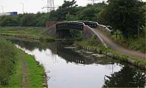
Rushall Junction with the Rushall Canal leading northwards under the bridge on the right.
|
|
| Specifications | |
| Status | Open |
| Navigation authority | Canal & River Trust |
| History | |
| Date completed | 1847 |
Rushall Junction (also called Newton Junction) is a special place where two canals meet. It's the southern end of the Rushall Canal and where it connects with the Tame Valley Canal. This junction is located in the West Midlands, England. It first opened in 1847. The Rushall Canal was built to link the Birmingham Canal Navigations (BCN) system with the Wyrley and Essington Canal. This connection happened after the two canal companies joined together in 1840.
Contents
The Story of Rushall Junction
Why Canals Were Built
Canals were like old highways for boats carrying goods. Sometimes, these "water highways" got very busy. The Tame Valley Canal was built to help with a big traffic jam. This jam was at a place called Farmers Bridge Locks in Birmingham. These locks were a main link between the Birmingham canal system and the route to London.
New Canal Connections
To solve the traffic problem, the Tame Valley Canal was planned. It was approved on the same day as another canal, the Birmingham and Warwick Junction Canal. Both canals opened on 14 February 1844.
The Tame Valley Canal stretched from Tame Valley Junction on the Walsall Canal to Salford Junction. The Birmingham and Warwick Junction Canal was a short link from Salford Junction to the Warwick and Birmingham Canal. This new route helped boats avoid many locks and made travel faster. Later, in 1929, this route became part of the Grand Union Canal.
Connecting the Canals
After the Wyrley and Essington Canal and the Birmingham Canal Navigations joined forces in 1840, they built more connections. One important link was the Rushall Canal. Work on it began after the Tame Valley Canal opened.
The Rushall Canal was built to connect the Tame Valley Canal to the Daw End Branch of the Wyrley and Essington Canal. This new canal opened in 1847. It included nine locks, which are like water elevators for boats. These locks raised the canal's level by about 65 feet (20 meters).
Where is Rushall Junction?
The Tame Valley Canal
From Rushall Junction, the Tame Valley Canal goes west. It runs next to the M6 motorway for about 0.5 miles (0.8 km). Then, the canal goes its own way, crossing the M5 motorway slip road and a railway line. It crosses these on special bridges called aqueducts.
The canal stays level for about 3.5 miles (5.6 km) until it reaches Tame Valley Junction. If you go the other way from Rushall Junction, the canal heads southeast. It passes under a bridge for walkers and the M5 motorway slip roads. About 2.2 miles (3.5 km) later, it reaches the top lock of the Perry Barr flight. This flight has 13 locks and lowers the canal's level by 106 feet (32 meters). Most of the Tame Valley Canal has paths on both sides for walking.
The Rushall Canal
The Rushall Canal goes north from the junction. It passes under a walking bridge and almost immediately under the M6 motorway. The walking path is on the west side of the canal. The canal stays level for about 0.9 miles (1.4 km) until it reaches the bottom of the Rushall locks.
After the motorway, there are three bridges. The third one, Hill Farm Bridge, is a special old bridge. It's made of cast iron and has brick and sandstone supports. Its railings have a cool criss-cross pattern. A walking bridge just east of the junction has a similar design and is also a special old structure.
 | Dorothy Vaughan |
 | Charles Henry Turner |
 | Hildrus Poindexter |
 | Henry Cecil McBay |

